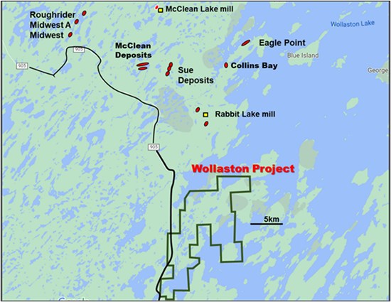
Forum Energy Metals Corp. (TSXV: FMC) (OTCQB: FDCFF) ("Forum" or "the Company") is pleased to announce that it has completed seven holes for 2,031 metres on its 100% owned Wollaston Lake Projected located 10 km southeast of Cameco's Rabbit Lake mill and 30 km southeast of OranoDennison's McClean Lake mill (Figure 1).
Highlights:
- Complete ground gravity coverage over prospective conductive trends.
- Anomalous uranium and boron in two drill holes along Gizmo trend requires follow-up drilling.
- Follow-up drilling required along newly identified coincident electromagnetic conductor/gravity trends and at historical uranium mineralization encountered on Burman Island.
Rebecca Hunter, Vice President, Exploration commented, "The regional geophysical surveys and limited drilling completed by Forum coupled with historical work done on this property have elevated our expectations for an economic uranium deposit on this well-located property in the Athabasca."
Ground Gravity Survey
A total of 4,573 stations at 100 metre by 100 metre spacings were collected this past winter over an area of 67.2 km2. Fourteen new gravity anomalies have been identified, many of which are associated with coincident moderate to strong EM conductors, which require follow-up (Figure 2).
Gizmo Trend Follow-up
New drilling along the Gizmo trend (Figure 3) has identified a graphitic pelite with a weak brittle overprint below the main elevated radioactivity, which may be the controlling structure that led to the weak uranium mineralization up to 1960 ppm U identified earlier in 2022 (see Forum News Release dated April 19, 2022). New assay samples from the 2022/2023 winter drilling program have returned additional elevated U values between 95 and 444 ppm with coincident elevated Boron up to 900 ppm and weak to moderate clay alteration adjacent to these discreet brittle fault structures. Follow-up of this structure will be a focus in future drilling programs along trend where a newly identified strong gravity low (750 m long) to the east is coincident with this prospective and uranium fertile structure/conductor system. This anomaly was not tested this winter due to terrain challenges getting into the area and will have to drilled using a helicopter-supported program.
New Trends
Additional high-priority conductors (A1, B1, B2 and B3) with coincident gravity anomalies have been identified (Figure 3). Along the A1 conductor historical drilling intersected several m-scale, moderately to strongly graphitic and pyritic zones with intervals of brecciation and moderate clay alteration. Weak elevated radioactivity is observed over 2.7 kilometres within and adjacent to these graphitic fault structures. Historical drill testing was largely widely spaced (~400 to 900 m) and was drilled at moderate angles to less than 100 metres depth. Additional investigation is warranted over the A1 conductor. Three additional conductive splays branch off the main A1 trend and coincide a new gravity anomaly as well.
The B1, B2 and B3 conductors are along the southern shore of Hidden Bay and along Ashley Peninsula (Figure 3). Historical, shallow depth and widely spaced drilling identified prospective conductive stratigraphy and one drill hole along the B1 conductor intersected elevated radioactivity (400 cps).
Burman Island
Located within the southern part of the Wollaston property is a prospective area that was initially explored due to numerous radioactive graphitic pelite and pegmatitic boulders being discovered on the island (Figure 3). Historical drilling by Wyoming Mineral Corp. intersected elevated radioactivity in 17 of 19 drillholes and returned numerous shallow drill intercepts (3O8. Two sub-parallel brecciated and sheared graphitic structures transect the area and require additional testing along strike and at depth. A new gravity anomaly along a sub-parallel conductor to the south of the island also warrants additional exploration.
Quality Assurance/Quality Control
Samples were collected as both composite chip samples (0.5 to 10metre intervals depending on lithological variance) and systematic split samples (10 cm intervals) that are submitted to SRC Geoanalytical Laboratories (an SSC ISO/IEC 17025: 2005 Accredited Facility) of Saskatoon, Saskatchewan for analysis. All samples are analyzed using ICP-MS for trace elements reported as partial and/or total digestion, ICP-OES for major and minor elements reported as total digestion, and fusion solution of boron by ICP-OES reported as total digestion. Uranium values for the Gizmo trend are reported as uranium partial values. Historical geochemical values are taken from past assessment reports and their data should be considered unverified and approximate.

Figure 1: Location of Forum's Wollaston Uranium Project. The project is located on Highway 905, 10km south of Cameco's Rabbit Lake Uranium Mill and 30km south of Orano/Denison's McClean Lake Uranium Mill (yellow squares). Uranium mineral deposits are outlined in red.
To view an enhanced version of this graphic, please visit:
https://images.newsfilecorp.com/files/4908/160993_ea88e8ccc49ebb40_003full.jpg

Figure 2: 2023 ground gravity survey. Residual gravity image over the Wollaston Project. Winter 2022/2023 drill holes are shown as red dots.
To view an enhanced version of this graphic, please visit:
https://images.newsfilecorp.com/files/4908/160993_ea88e8ccc49ebb40_004full.jpg

Figure 3: Wollaston Project conductor and gravity trends. Total magmatic intensity image overlain with the new conductor trends and gravity anomalies. Winter 2022/2023 drill holes are shown as red dots.
To view an enhanced version of this graphic, please visit:
https://images.newsfilecorp.com/files/4908/160993_ea88e8ccc49ebb40_005full.jpg
Rebecca Hunter, PhD., P.Geo., Forum's Vice President of Exploration and Qualified Person under National Instrument 43-101, has reviewed and approved the contents of this news release.
About Forum Energy Metals
Forum Energy Metals Corp. (TSXV: FMC) (OTCQB: FDCFF) is a diversified energy metal company with uranium, copper, nickel, and cobalt projects in Saskatchewan, Canada's Number One Rated mining province for exploration and development, a strategic uranium land position in Nunavut and a strategic cobalt land position in the Idaho Cobalt Belt.
For further information: https://www.forumenergymetals.com/
This press release contains forward-looking statements. Forward-looking statements address future events and conditions and therefore involve inherent risks and uncertainties. Actual results may differ materially from those currently anticipated in such statements. Forward-looking information is subject to known and unknown risks, uncertainties and other factors that may cause Forum's actual results, level of activity, performance or achievements to be materially different from those expressed or implied by such forward-looking information. Such factors include but are not limited to: uncertainties related to the historical data, the work expenditure commitments; the ability to raise sufficient capital to fund future exploration or development programs; changes in economic conditions or financial markets; changes commodity prices, litigation, legislative, environmental and other judicial, regulatory, political and competitive developments; technological or operational difficulties or an inability to obtain permits required in connection with maintaining or advancing its exploration projects.
ON BEHALF OF THE BOARD OF DIRECTORS
Richard J. Mazur, P.Geo.
President & CEO
Neither the TSX Venture Exchange nor its Regulation Services Provider (as that term is defined in the policies of the TSX Venture Exchange) accepts responsibility for the adequacy or accuracy of this release.
For further information contact:
Rick Mazur, P.Geo., President & CEO
mazur@forumenergymetals.com
Tel: 604-630-1585
To view the source version of this press release, please visit https://www.newsfilecorp.com/release/160993