The Conversation (0)

Arcadia Minerals Ltd (ASX:AM7, FRA:8OH) (Arcadia or the Company), the diversified exploration company targeting a suite of projects aimed at Tantalum, Lithium, Nickel, Copper and Gold in Namibia, is pleased to announce a geophysical interpretation conducted by the Company’s geologists of the recently completed helicopter borne Electro-Magnetic Survey3.
HIGHLIGHTS
Jurie Wessels, the Chairman of Arcadia stated: “The interpretation affirmed our geological model and hypothesis that the Bitterwasser Basin area conforms to the structural requisites of possibly becoming a globally significant Lithium province. From the data it is evident that several entrapment sites were formed through tectonic activity where highly conductive brine fluids could be accumulated. In addition, there is a distinct concurrence between structures observed from EM data and the formation of mineralised lithium clay pans. This further enhances the likelihood of the pans, where mineralisation tends to increase to depth, having been mineralised through lithium rich brine water-table fluctuation. By comparing water quality of holes drilled outside of the anomalous areas from publicly available data to the levels of electro- conductivity within EM anomalous zones we expect highly concentrated dissolved solids of salts (brines) to be encountered within the anomalous zones.
Our focus is now to drill three stratigraphic holes to verify the geophysical results, to increase our geological understanding of the Bitterwasser basin and to obtain valuable information regarding the sediments associated within the basin. This will be necessary before we embark on a targeted brine-borehole drilling programme. Although not the objective, it is not excluded that stratigraphic drilling could lead to the discovery of a significant brine deposit at Bitterwasser.”
GEOPHYSICAL INTERPRETATION
Interpretation of government Magnetic data purchased from the Ministry of Mines and Energy of Namibia indicates the presence of three major north-south trending faults that are considered responsible for the formation of the Bitterwasser half graben structure. Various en-echelon faults (i.e. faults, or tension fractures, that are oblique to major structural trends) are associated with the large north-south trending fault structures (see Figure 1 right-hand image). The north-east southwest trending fault in the southern portion of the magnetic image is considered to have caused an up-lift of the basement basalt. As a result, the barrier for the creation of the Bitterwasser basin was formed thereby creating a closed basin and trapping water flow from the north and acting like a dam wall (indicated by the red striped polygon on the right-hand image).
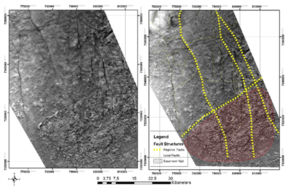 Figure 1 – Maps showing the Magnetic Survey data with and without interpretation, the red striped polygon on the southern portion of the area shows the basement high.
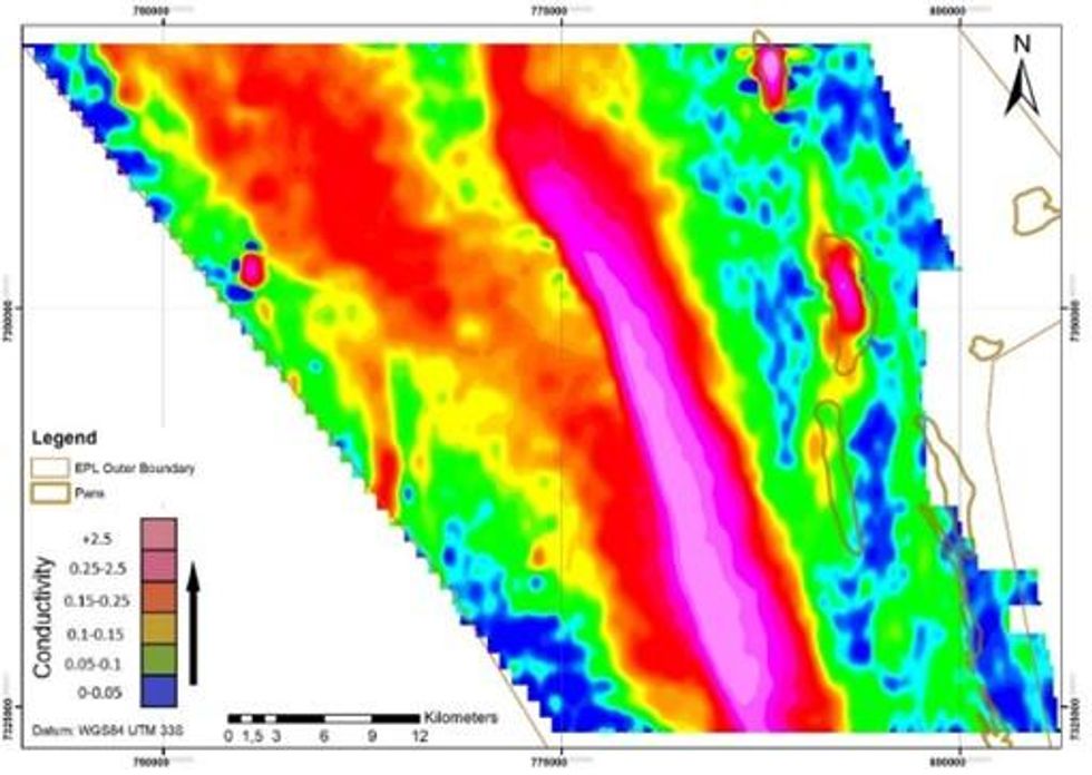 Figure 2 – EM survey Results showing three anomalous bodies (represented by pinkish colour)
The interpretation of both the Magnetic and Electro-Magnetic data (as represented in figure 3 below) indicates a well-defined correlation between the anomalies (derived from the Electro-Magnetic data and shown in figure 2) and structural features (derived from the Magnetic data and shown in figure 1). The largest EM anomaly (42km by 9km) is associated with a major north-northwest trending fault structure and the most southern, north-east southwest trending “dam wall” fault. The two smaller anomalies, which are concordant with the Eden Basin (8km by 2.5km) and the Madube Basin (5km by 1.5km) are associated with en echelon faults associated with the two large parallel north-northwest trending fault structures. The formation of the three basins identified so far is thus considered to have been structurally controlled.
This article includes content from Arcadia Minerals, licensed for the purpose of publishing on Investing News Australia. This article does not constitute financial product advice. It is your responsibility to perform proper due diligence before acting upon any information provided here. Please refer to our full disclaimer here.