GoldSpot Provides High Quality Targets for Pacton’s Red Lake Project
GoldSpot Discoveries Corp. is pleased to announce that Pacton Gold Inc. has extended its contract with GoldSpot, AI-leaders in exploration.
GoldSpot Discoveries Corp. (TSXV:SPOT) (“GoldSpot” or the “Company”) is pleased to announce that Pacton Gold Inc. (“Pacton”) has extended its contract with GoldSpot, AI-leaders in exploration. Pacton is currently drilling targets, some of which were delineated by GoldSpot in 2019. As a result of the extension, Pacton will continue to benefit from GoldSpot’s use of machine learning analysis on available data to help target drilling and refine advanced exploration efforts on Pacton’s Red Lake properties.
Pacton Executive Chairman Dale Ginn states, “GoldSpot continues to support Pacton Gold by providing its expertise in both conventional geoscience and advanced artificial intelligence, and we appreciate their strategy of investing in the companies they work with. Field and AI work to date has assisted greatly in prioritizing high probability targets and has enabled us to rapidly move to the drilling stage. Our geology team is looking forward to further input from GoldSpot, especially in anticipation of drill results and the upcoming field season.”
Machine Learning Improving the Efficiency of Field Investigations
GoldSpot employed several techniques to achieve success in field investigations in 2019. Some of these include:
- Remote targeting of prospective areas
- Remote rock-type mapping
- Outcrop finding
GoldSpot Identifies Highly Prospective Areas
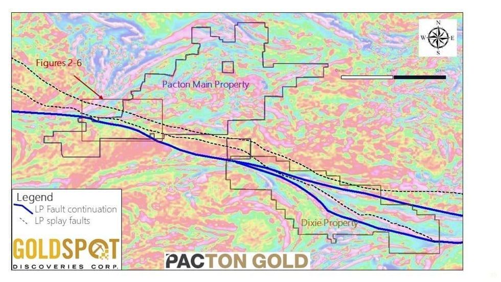
GoldSpot employed a multi-stage approach to identifying the most prospective areas in Pacton’s 143 km2 Red Lake property holdings. To optimize a short field season, GoldSpot identified areas within this large property to focus exploration activities. Great Bear’s Dixie Property lies immediately to the southeast of Pacton’s Main Claim block (Figure 1). GoldSpot focussed on finding the extension of the heavily and broadly mineralized LP Fault zone that hosts the Rimini Zone mineralization.
Tracing the LP Structure through Pacton’s property
GoldSpot’s expert geophysicists traced the significant LP fault from the Dixie property through Pacton’s South and Main Claim blocks. Figure 1 illustrates the interpreted trace of the LP Structure and two interpreted subsidiary structures to the north through Pacton’s properties. GoldSpot considers all three structures prospective. This structural corridor represents nearly 20 km2.
Figure 1 – Trace of the LP Structure through Pacton Gold’s property (Red Lake, Ontario).
Tracing Alteration
To further refine the area of investigation, GoldSpot used multiple coincident signals associated with silicification to home in on zones of alteration.
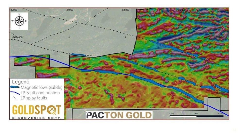
- Areas of subtle low magnetic signal adjacent to the LP and splay structures were identified. Silicification can result in localized magnetic destruction.
Figure 2: Zones of subtle low magnetic signal adjacent to or within interpreted structures.
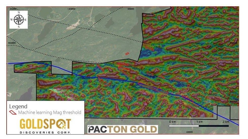
- Spatially unbiased evaluation of magnetic survey data using machine processing to reveal magnetic lows too subtle of a human (biased) evaluation. Similar to step 1 this process is used to identify zones where silicification may have resulted in localized zones of magnetic destruction in host rocks. After the processing, small linear trends of weak magnetic lows were identified. Figure 3 shows the machine-based thresholding product with the identified magnetic low trends.
Figure 3: The spatial product of machine-based thresholding applied to magnetic survey data and the trends of linear weak magnetic lows it revealed.
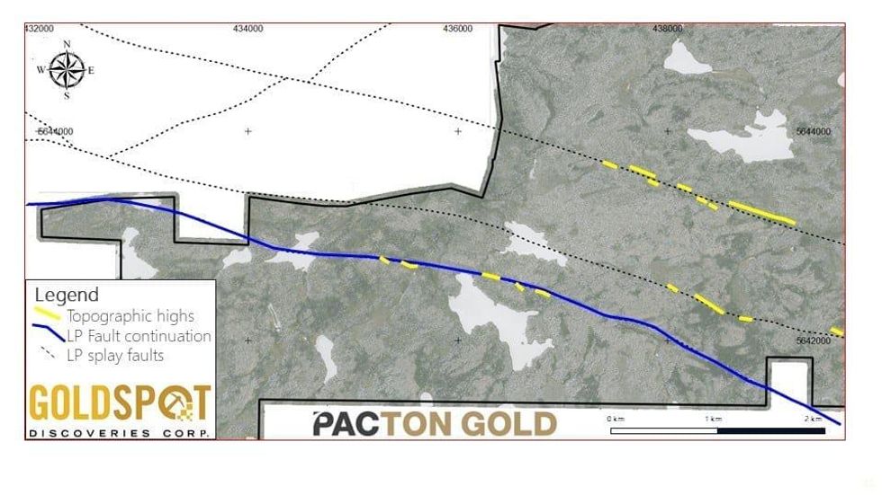
- Linear zones of slightly elevated topography. Silicification can result in the hardening of a host rock resulting in a positive weathering effect. Detailed Lidar data was used to identify linear zones of subtle (less than 1 m) elevation increase relative to the surrounding land. Figure 3 illustrates areas of slightly elevated topography adjacent to or within faults.
Figure 4: Zones of elevated topography adjacent to or within interpreted structures plotted on Lidar image.
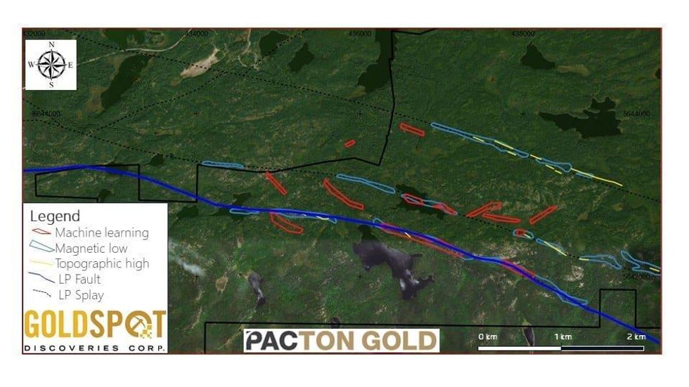
The combination of these three targeting products further focussed exploration efforts on Pacton’s Main Red Lake property. Areas where the LP fault extension and its splays coincide with topographic highs and zones of subtle magnetic lows identified by both a geophysicist and by machine learning technology are considered most prospective for silica-sericite alteration associated with gold mineralization (Figure 5).
Figure 5: Combined inputs of alteration targeting. Zones of overlap of all features are most prospective.
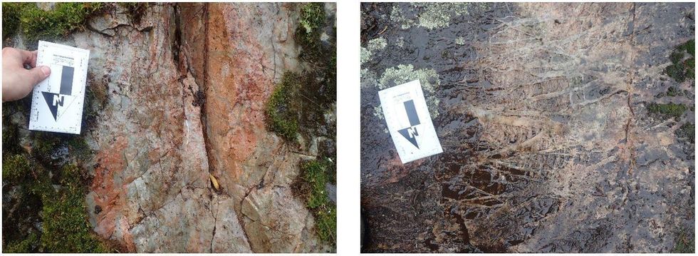
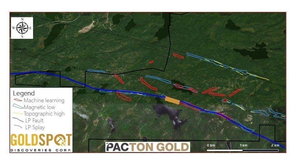
GoldSpot geologists visited one of these target areas on the final two days of fieldwork in 2019. Intense silica-sericite and quartz stockwork alteration types (Photos 1 and 2) were discovered in an area approximately 400 m by 125 m where silica/silica-sericite alteration was predicted (Figure 6).
Photo 1 (Left): Pervasive silica-sericite alteration. Photo 2 (Right): Quartz stockwork veins.
Figure 6: Alteration target areas with identified zone of silica (quartz stockwork veins) and silica-sericite alteration shown as golden rectangle.
This successful proof-of-concept has given renewed impetus to test this discovered alteration zone associated with the LP Fault extension. Only one of the significant overlapping targets was visited. This leaves several areas of high potential targets for ground-truthing and discovery in the 2020 field season.
GoldSpot Conducts Remote Rock-type Mapping
Because certain rock-types are particularly prospective, GoldSpot has developed machine learning algorithms that can use existing geophysical data to remotely identify these prospective rock-types. In the main Red Lake gold camp (mines including Red Lake, Madsen, Williams, Cochenour, etc.) the interface of ‘mafic’ and ‘ultramafic’ rocks, combined with structural factors (F2 closures and faults) and zones of quartz-carbonate alteration are considered prospective.
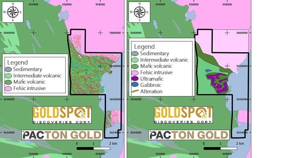
GoldSpot applied a combination of machine-assisted learning and insights from both geophysicist and geologist to Pacton’s NE Block of claims. A significantly refined geology map resulted (Figure 7). Of particular note are:
- Previously unmapped ultramafic units (confirmed in historic drilling)
- An apparent fold interference pattern (F1 – F2 interference) of the mafic-ultramafic contacts
- Areas of relatively low-magnetic signal within the ultramafic unit that are interpreted as alteration zones.
These three features identified in GoldSpot’s remote rock-type mapping correspond to the ingredients that characterise the high-grade gold mineralization of the main Red Lake gold camp.
Figure 7 – Enhancement of the geological map through remote rock-type mapping.
Machine Learning Used as an Outcrop Finding Tool
GoldSpot used a proprietary, outcrop-finding, machine learning tool to help its field mapping geologists by reducing their daily traverse preparation work. This tool uses available satellite imagery and topographic information to predict where bedrock exposures are likely to be found. When working in the remote, glaciated, boreal forest geologists plan traverses that are designed to optimize the likelihood of finding outcrop.
To do this a detailed analysis of images of the terrain are scrutinized and interpreted to identify likely outcrop areas. This can be an onerous and painstaking undertaking when done manually. GoldSpot’s tool automates the process and generates outcrop probability maps for large areas in minutes. This tool was used to predict outcrops with great success on both the Main and NE blocks geological field work saving the geologists time in the office and in the bush.
The technical information in this press release has been prepared in accordance with the Canadian regulatory requirements set out in National Instrument 43-101 (Standards of Disclosure for Mineral Projects) and reviewed and approved by Lindsay Hall, professional geoscientist (APGO # 0891), a Qualified Person as defined in NI 43-101.
About GoldSpot Discoveries
GoldSpot Discoveries Corp. (TSXV: SPOT) is a Canadian technology company transforming a traditional industry using artificial intelligence and machine learning. As the first publicly-traded AI company in mineral exploration, GoldSpot Discoveries uses machine learning as a powerful extension of geological brainpower to unlock deep value in data. In addition to service offerings and strategic investments, GoldSpot has developed a first of its kind AI driven trading platform giving investors a new way to play the mining space.
For further information please contact:
Denis Laviolette, President, CEO and Director
GoldSpot Discoveries Corp.
647-992-9837
Neither the TSX Venture Exchange (“TSXV”) nor its Regulation Services Provider (as that term is defined in the policies of the TSXV) accepts responsibility for the adequacy or accuracy of this release.
Click here to connect with GoldSpot Discoveries Corp. (TSXV: SPOT) for an Investor Presentation
