The Conversation (0)
Nighthawk Gold Corp. (“Nighthawk” or the “Company”) (TSX:NHK; OTC:MIMZF) is pleased to announce the latest exploration results on its 100% owned Indin Lake Gold Property in the Northwest Territories, Canada.
Nighthawk Gold Corp. (“Nighthawk” or the “Company”) (TSX:NHK; OTC:MIMZF) is pleased to announce the latest exploration results on its 100% owned Indin Lake Gold Property in the Northwest Territories, Canada. The fieldwork season ran from June to early September 2018 and included systematic bedrock mapping and sampling of several priority target areas. A total of 2,153 grab samples and channel samples were collected, resulting in the discovery of new high-grade gold showings, as well as the confirmation and expansion of historical occurrences.
The company also drilled the first ever holes at the Swamp Project (“Swamp”), a newly defined and laterally extensive gold system west of the Colomac Gold Project (“Colomac”). Three holes tested two new gold discoveries at surface and confirmed the extension of mineralization to depth.
Dr. Michael Byron, President & CEO commented, “We consolidated the Indin Lake gold camp, including all its historical gold mines, deposits, and showings, because we were convinced of its untapped capacity to deliver significant gold ounces. It has the same characteristics as does any productive high-profile Archean gold camp, with an abundance of high-grade showings and deposits with widespread mineralization in a range of styles that are largely hosted in brittle regimes. Each year our field exploration programs have been successful in expanding known showings and discovering new ones, a testament to the land’s potential and a validation of our thesis.”
“We have the resources to continue advancing several of our prominent Indin Lake area deposits and prospects in tandem with our ongoing exploration activities focused at growing the Colomac resource. In 2018, just over fifty-percent of drilling was directed at some of our more prospective regional targets including the four Leta Arm gold deposits, Treasure Island, Damoti Lake and Swamp. We look forward to our 2019 campaign, as we intend to build upon our previous successes and expand our geological mapping, prospecting, and drilling programs to continue to advance some of our other key prospects to drill ready status.”
HIGHLIGHTS:
- New high-grade gold discovery at Fishhook Gold Project (“Fishhook”) – Grab samples returned up to 174.50 grams per tonne gold (“gpt” “Au”) from mineralized iron formation;
- New area of high-grade gold mineralization within the Nice Lake Sill – Grab samples returned up to 41.90 gpt Au;
- New high-grade gold discovery at Andy Lake Project (“Andy Lake”) – Samples of quartz vein returned up to 42.10 gpt Au;
- Expansion of high-grade gold at Treasure Island Gold Project (“Treasure Island”) – Sampling of historical trench returned up to 45.60 gpt Au;
- Elevated gold values at Laurie Lake showing (“Laurie Lake”), defined over a 1.3 km by 1.7 km area – Surface samples ranged from 1.05 gpt Au up to 22.50 gpt Au;
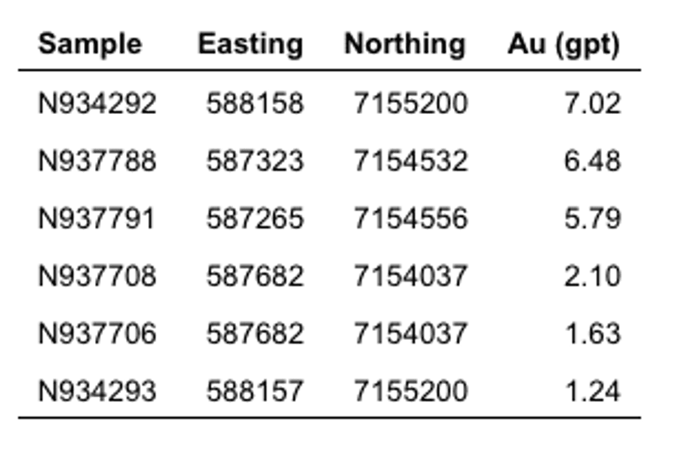
- Bay Showing – Surface samples assayed from 0.56 gpt Au to 7.02 gpt Au, across five historical showings spanning a 1.2km by 1.8km area northeast of Laurie Lake;
- First holes drilled at Swamp Project – Drilling undercut new surface gold showings and successfully traced mineralization to depth;
- Barker-Vidie Showing – Grab sample assays 23.60 gpt Au.
2018 Regional Field Exploration Results and Discoveries
Treasure Island – Additional Discoveries of Strong Surface Mineralization
Treasure Island lies 11 km north of Colomac (Figure 1) within the eastern end of the Treasure Island-Laurie Lake Mineralized Corridor, a 7 km long tract that hosts several surface gold showings. Recognition of the abundance of gold throughout this part of the Indin Lake Greenstone Belt prompted Nighthawk’s extensive prospecting and mapping exploration activities of 2011, 2017 and 2018, as well as exploration drilling in 2011 and 2018.
Nighthawk first drilled Treasure Island in 2011 to test the Main Zone along the southern edge of the island. Five holes (1,452 metres) intersected five stacked mineralized panels in association with a sheared volcanic/sedimentary rock contact. All holes reported gold mineralization (see press release dated May 31, 2011) confirming the historical accounts of gold in association with the faulted contact. Follow-up activities resulted in the discovery of new surface showings, and in 2018 the Company drilled sixteen holes (4,035 metres) that successfully extended existing zones in all dimensions including intersections of new high-grade zones at depth, highlighted by 18.50 metres of 7.37 gpt Au, including 8.00 metres of 16.14 gpt Au, and 5.25 metres of 22.00 gpt Au (see press release dated October 22, 2018). Drilling focused on the Main Zone’s highly altered and silicified 200-metre-wide mineralized envelope that spans the regional contact between volcanic rock and sedimentary rock units.
In 2018 the Company also drilled its first holes into the East Zone, a second area of mineralization 500 metres east of the Main Zone (Figure 2). Results confirmed the historical reports of gold and delivered a new shallow high-grade intersection spanning 11.75 metres of 10.78 gpt Au, including 6.50 metres of 19.15 gpt Au (see press release dated October 22, 2018), an indication that the high-grade nature of the Main Zone may exist throughout the 700 metres of mineralized stratigraphy.
The area between the Main Zone and East Zone remains largely untested, as does the 4 kilometres that separates Treasure Island from Laurie Lake to the west, leaving more than 75% of the Treasure Island-Laurie Lake Mineralized Corridor to be explored.
Field Activities
Grab samples collected in 2011 from the historical Booty Showing along the northern shore of the Island (Figure 2) assayed up to 13.35 gpt Au. The area was revisited in 2017 as part of an extended regional exploration program resulting in the discovery of a new high-grade gold surface showing, the Seadog showing, 750 metres west of the Booty Showing and 1.0 kilometre north of the Main Zone, where grab samples returned up to 27.80 gpt Au, and 19.85 gpt Au from a 1.0 metre channel sample (see press release dated April 12, 2018).
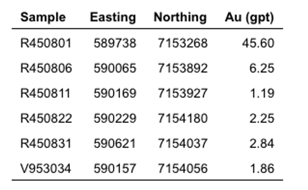
The western portion of the island was systematically sampled during the 2017 program, and detailed sampling of the island’s eastern sector was completed in 2018, highlighted by a 45.60 gpt Au grab sample collected from a historical trench in metasedimentary rock (Table 1, Figure 2). Four additional samples collected north and east of the trench and returned values ranging from 1.19 gpt to 6.25 gpt. All gold bearing samples are fine to medium grained metasediments with 0.5% to 1.0% disseminated pyrite and moderate iron oxide alteration.
Treasure Island continues to be a high-priority area for the Company. New surface showings of high-grade gold mineralization are found throughout the project, and the high-grade gold drill intersections that have been documented over a 700-metre strike length remain open. Its exploration upside potential is largely untested and is considered a prime candidate to host a significant deposit.
Table 1. Treasure Island – 2018 select grab sample results
Nice Lake North – New Discoveries Within Nice Lake Sill
The Nice Lake sill was discovered in 2016 while prospecting a large linear anomaly 1.5 km east of Colomac (Figure 1) that shows similarities in magnetic intensity and anomaly shape to both the Colomac and Goldcrest sills. Areas of quartz diorite bedrock are associated with magnetic highs that delineate the newly discovered sill which was subsequently traced for over 4.0 km in outcrop along a trend sub-parallel to the Colomac sill. Anomalous grab samples (up to 2.61 gpt Au) were collected over much of its length (see press release dated February 7, 2017).
Follow-up field work in 2017 successfully expanded the discovery. Grab samples returned up to 4.19 gpt Au (see press release dated April 12, 2018), extending the length of the sill to over 10 km. Outcrop mapping between Colomac, Nice Lake, and areas east of Nice Lake identified multiple smaller sills within this 2-kilometre-wide corridor. Detailed mapping has shown that the sills exhibit the same intensity of deformation and alteration as that found in association with gold within the Colomac Main Sill.
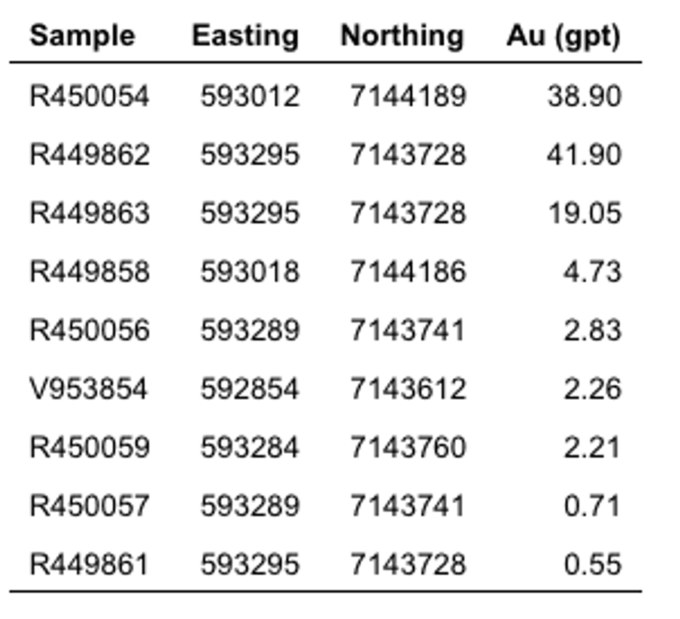
In 2018 high-grade gold samples were collected from two locations northeast of Baton Lake (Figure 3). Sample R450054 returned 38.90 gpt Au from a gossanous zone of sheared chloritic-mafic volcanic rock. Approximately 530 meters southeast of this location visible gold was discovered in a quartz-vein within gossanous sulfide-rich blue quartz eyed gabbro that assayed 41.90 gpt Au. Additional samples were taken proximal to the high-grade samples and are included in Table 2. Several highly gossanous patches were noted along the 530 meters separating these two high-grade sample sites. This represents a key area for follow-up work, as these grades could be an indication that a higher-grade domain may be present similar to Zone 1.5 within the Colomac Main Sill.
Table 2. Nice Lake North – 2018 select grab sample results
Andy Lake – New High-Grade Gold Discovery
Andy Lake is located 20 km south of Colomac within the Gamey Lake Volcanic Panel, a N-S trending volcanic rock package bordered by metasedimentary rocks to the east and west (Figure 1). The Andy Lake Granodiorite and its associated granitoid dykes intrude the panel. Regional sampling in 2012 identified the area for follow-up work and in 2016, a new style of Au-Ag-Bi mineralization was discovered that had not been previously identified within the Indin Lake Greenstone Belt (see press release dated February 7, 2017). Mineralization is hosted by felsic and intermediate intrusions, characterized by a high Ag:Au ratio, and highly anomalous bismuth. Gold with high silver and bismuth occur at both ends of Andy Lake in a granite host 1.3 km apart (Figure 4).
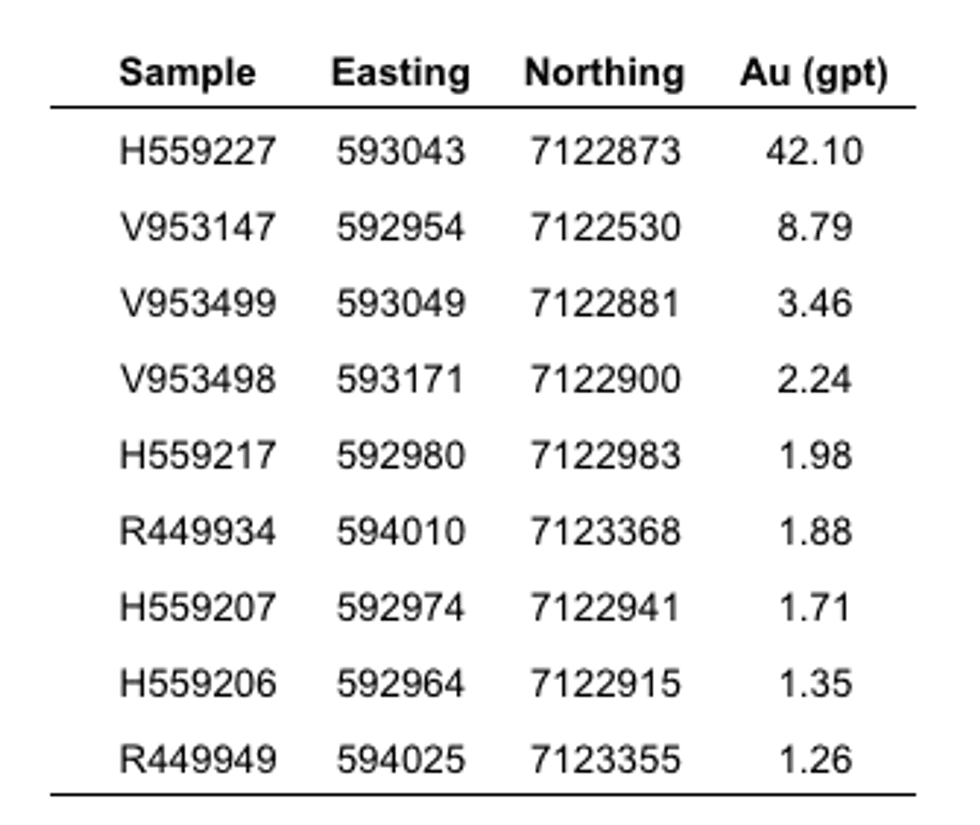
In 2018 a 1:20,000 scale mapping program covered much of the Gamey Lake Volcanic Panel to examine its structural and lithological characteristics and assess its economic potential. Detailed mapping and sampling (161 samples) generated a new area of high-grade gold mineralization just south of Andy Lake (Figure 4). A new quartz vein discovery 83 metres long and 2 metres wide yielded 8 samples with assays between 0.90 gpt Au and 2.00 gpt Au, suggesting that larger veins are present but perhaps hidden by overburden. Typically, quartz veins are between 1-30 cm-wide and discontinuous, often hematite altered with visible pyrite and chalcopyrite. Although veins are expansive, extending in an NNE-SSW trend away from the Andy Lake Granodiorite, gold contents are highest in the area between Andy Lake and ‘small Andy Lake’ (Table 3, Figure 4) where samples range from 0.50 gpt Au to 42.10 gpt Au, a possible indication that the most prospective style of mineralisation noted to-date is intrusion related gold system quartz veins associated with the Andy Lake Granodiorite. The area is also anomalous in Ag, Bi, Mo, Pb, and Cu.
Andy Lake has grown from an interesting new polymetallic showing to a highly prospective new gold prospect, that with limited fieldwork, has shown its potential for hosting an intrusion related gold system dominated by mineralized quartz veins. Additional fieldwork is being planned that will include detailed work within the new discovery area between the two lakes in preparation for drilling.
Table 3. Andy Lake – 2018 select grab sample results
Laurie Lake – High-Grade Gold Showings
The Laurie Lake showings are 8.5 km northwest of Colomac along the western extent of the Treasure Island-Laurie Lake Mineralized Corridor (Figure 1). Regional geology consists of alternating mafic metavolcanic and turbiditic metasedimentary units. The area of interest is dominantly underlain by mafic metavolcanic rocks consisting of gabbro, porphyry intrusions and pillowed volcanic flows.
Historical trenches, overburden pits and channel sample sites lie along a NE-SW mineralized trend consistent with the western extension of the Treasure Island Laurie Lake Mineralized Corridor. All known historical drill holes have intersected gold mineralization highlighted by 6.56 gpt Au over 1.40 meters. Nighthawk’s 2014 regional exploration program included geological mapping, prospecting, and outcrop sampling, validating many of the area’s previously known gold occurrences.
Gold bearing sulphide mineralization within the Laurie Lake iron formation was sampled extensively in 2014. Forty-four samples were collected and analyzed for gold, with 38 containing gold at or above detection limit with the best sampled from an intensely oxidized foliated banded iron formation that assayed 4.17 gpt Au.
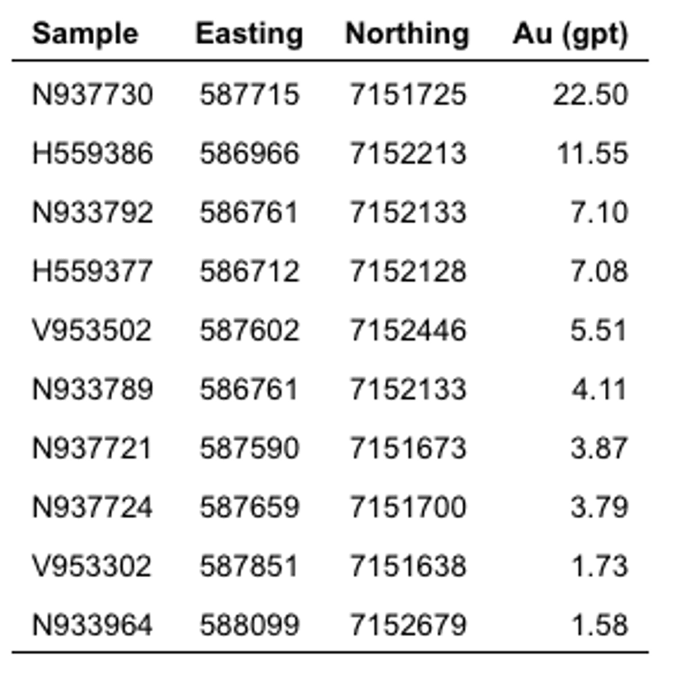
In 2018 the prospecting program revisited the area to expand on the 2014 work. Forty-one additional samples were collected showing elevated gold values distributed over an area of 1.3 km by 1.7 km (Figure 5), of which 14 grab samples returned values ranging from 1.05 gpt Au to 22.50 gpt Au (Table 4), while an additional 27 samples ranged from 0.13 gpt Au to 0.84 gpt Au.
The Treasure Island-Laurie Lake Mineralized Corridor is another example of the scale that some of these vastly underexplored gold systems within the Indin Lake Greenstone Belt exhibit. A similar scale of mineralized strike length is also present at Colomac and Leta Arm.
Table 4. Laurie Lake – 2018 select grab sample results
Bay Showings
The Bay Showings lie 2.5 kilometres northeast of Laurie Lake within the northern boundary of the Treasure Island-Laurie Lake Mineralized Corridor (Figure 1). Local stratigraphy is dominated by mafic to intermediate metavolcanic rocks, gabbro, and porphyry intrusions, with metasedimentary rocks sandwiched between volcanic sequences. Along the western shoreline of Spider Lake an oxide facies iron formation lies proximal to the volcanic-sediment contact.
Table 5 contains select sample assay results from the five showings that constitute the Bay Showings (Figure 6). Mineralization straddles gossanous metavolcanic and metasedimentary rock contacts transected by quartz veins. Metasedimentary rocks are the principal mineralized host.
In conjunction with the abundance of Laurie Lake gold showings to the south, the entire western extension of the Treasure Island-Laurie Lake Mineralized Corridor appears as well mineralized as the eastern Treasure Island area, but much less explored. Additional fieldwork is needed to better determine the area’s potential, however the presence of high-grade gold and mineralization that is well dispersed throughout points to its untapped potential.
Table 5. Bay Showings – 2018 select grab sample results
Swamp
Swamp lies 6 km northwest of Colomac (Figure 1), in association with a large deformation zone and intense iron-carbonate alteration; hallmark features of Archean lode-gold deposits and similar to those found within the Timmins Gold Camp. An altered gabbro intrusion lies east of the main Swamp showing and hosts gold mineralization in 15 centimetre to 1.5 metre wide quartz-carbonate veins. Intense silicification as well as iron-carbonate define the alteration.
Nighthawk established the core of the showing to have an across strike outcrop width of 85 meters with a highly strained and altered corridor that extends for approximately 400 meters to the southwest (Figure 7). Assays of up to 43.60 gpt Au were generated from sampling in 2012 and up to 4.33 gpt Au from grab samples taken in 2017. Preliminary channel sampling returned 2.98 gpt Au over 1.0 metre (see press release dated April 12, 2018). Detailed infill sampling has revealed that a broad area of anomalous gold is associated with the showing and has a minimum footprint of 1.6 km by 1.0 km.
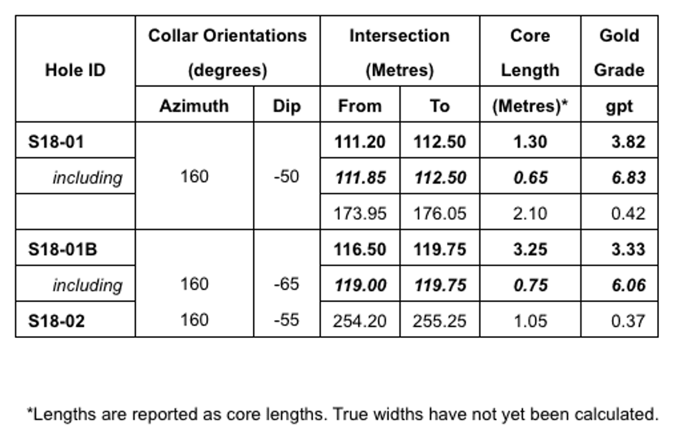
In the fall of 2018, a limited program of channel sampling was laid out across two outcrop areas that host the new showings with assays returning up to 2.55 gpt Au (Table 6). Induced Polarization (IP) and magnetometer ground surveys were previously completed to assist with the placement of three holes that were drilled below two surface gold showings and corresponding IP anomalies.
Two holes (S18-01 and S18-01B) were drilled from the southern collar location to test beneath a showing with a corresponding IP chargeability high (Figure 7). Both holes intersected mineralization 60 metres to 80 metres directly below the surface mineralization and centred on the IP anomaly (Table 7). The host rock is carbonatized mafic volcanic rock with minor sulphides. Two occurrences of visible gold were noted in hole C18-01B with the best intercept returning 3.33 gpt over 3.25 metres. The strong correlation between mineralization and the IP anomaly suggests continuity within the system, and earmarks IP as an effective tool for tracking mineralization at Swamp. Additional work is being panned to better asses the area’s broader potential but early indications are very encouraging. Hole S18-02 was drilled below the prospect’s best surface showing where a 2012 grab sample assayed 43.60 gpt Au (Figure 7). It intersected an area of significant quartz veining at 135 metre depth with trace gold but failed to effectively explain the IP anomaly.
These are the first holes ever drilled at Swamp and the last ones completed in 2018 and have established that mineralization continues to depth. However, more work needs to be carried out to fully evaluate its 1.6 km by 1.0 km mineralized footprint.
Table 6. Swamp – 2018 select channel sample results
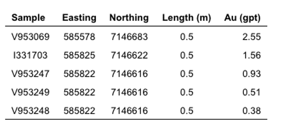
Table 7. Swamp – 2018 drill results
Fishhook – High-Grade Gold In Iron Formation
Fishhook consists of several historical gold showings spanning an area 6 km by 1.5 km, 40 km southwest of Colomac. Showings are hosted by complex folded amphibolitic oxide-silicate iron formation within a sequence of metasedimentary rocks, an environment similar to the Damoti Lake Gold Deposit (“Damoti Lake”), (Figure 1). Iron formation is characterized by tightly folded, narrow 1 meter to 3-meter-wide lenses that locally exceed 10 meters due to folding. Fold noses appear to be a focal point for localizing gold mineralization where mineralization is commonly confined to the host silicate iron formation. Between 1994 and 1996, Gitennes Exploration conducted outcrop mapping, surface sampling, geophysics and trenching that culminated in 109 drill-holes that tested 12 major gold occurrences. Drilling was generally restricted to a maximum depth of 100 meters. Historical intersections of narrow high-grade gold are confined to individual iron formation bands or where mineralization extends between the bands of iron formation; highlights include 8.6 metres of 14.21 gpt Au, 13.55 metres of 7.36 gpt Au, and 12.92 metres of 5.44 gpt Au.
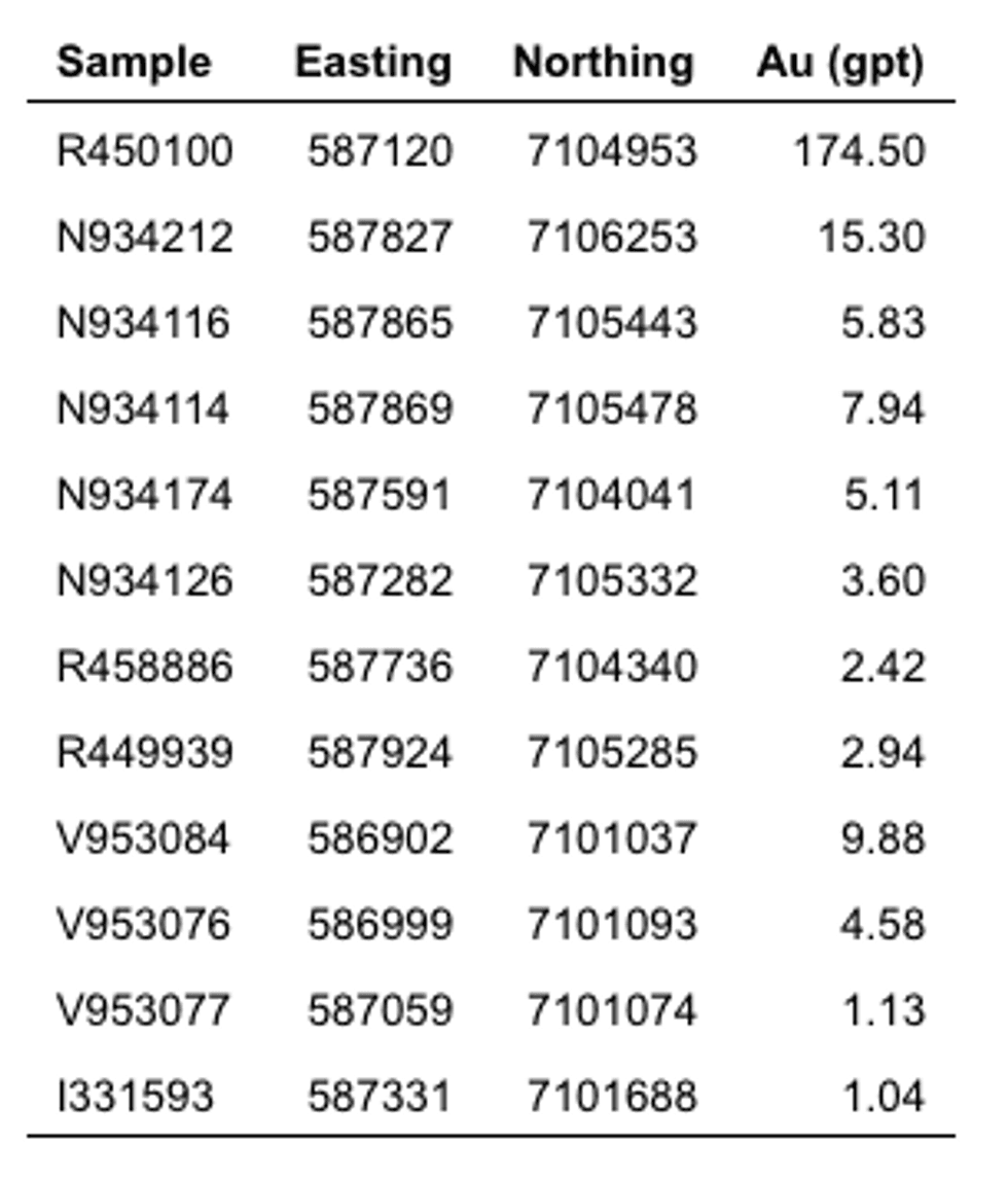
The objective of the 2018 mapping and sampling program was to infill areas prospected during Nighthawk’s 2011 regional field program and resample select 2011 sample locations for lithogeochemical analyses. This work is highlighted by a grab sample taken from a medium grained, intensely iron oxide altered banded iron formation that assayed 174.50 gpt Au (Figure 8). Several other samples returned gold grades over 1.0 gpt Au verifying the projects aerially extensive and highly anomalous nature (Table 8).
Fishhook is the Company’s southernmost project and has received very little attention to-date, but it’s high-grade nature and extensive mineralization is consistent with what is noted throughout the gold camp, and a project that will be looked at in greater detail given its resemblance to the Company’s Damoti Lake high-grade gold deposit.
Table 8. Fishhook – 2018 select grab sample results
Nighthawk’s 899 km2 Indin Lake Gold Project encompasses many other highly prospective and untested prospects. Two of these were examined and sampled in 2018 and generated highly anomalous gold assays. At the Albatross Showing 15 km southwest of Colomac (Figure 1) prospecting focused on a regional contact between metavolcanics rocks and metasedimentary rocks intercalated with fine grained metagabbro. Grab samples taken from altered gabbro range from 0.57 gpt Au to 4.02 gpt Au. This same geological setting hosts the Cass deposit (located 1 kilometre to the east see press release dated October 27, 2014), where a small historical open pit deposit was developed within a gabbroic body.
Eleven grab samples were collected from the Barker-Vidie showing, that lies 27 kilometres south-southwest of Colomac (Figure 1). A sample taken from a horizontal quartz carbonate vein in altered mafic meta-volcanic rock assayed 23.60 gpt Au. Additional work is needed to further delineate the extent of mineralized quartz veining associated with this showing.
Technical Information
Nighthawk has implemented a quality-control program to comply with best practices in the sampling and analysis of drill core. Drill core samples were transported in security-sealed bags for analyses at ALS Global Assay Laboratory in Vancouver, BC (“ALS Global”). ALS Global is an ISO/IEC 17025 accredited laboratory. Pulp and metallics assaying for gold was conducted on the entire pulverized sample.
As part of its QA/QC program, Nighthawk inserts external gold standards (low to high-grade) and blanks every 20 samples in addition to the standards, blanks, and pulp duplicates inserted by ALS Global.
About Nighthawk
Nighthawk is a Canadian-based gold exploration company with 100% ownership of a district-scale land position within the Indin Lake Greenstone Belt, located approximately 200 km north of Yellowknife, Northwest Territories, Canada. Nighthawk is focused on advancing the Colomac Gold Project with a current inferred resource of 2.6 million ounces of gold (50.3 million tonnes at an average grade of 1.62 grams per tonne gold), as well as advancing its other regional gold deposits and showings within this largely underexplored Archean gold camp.
The Company has an experienced and dedicated team and is well funded to complete its goals and objectives over the next 12-18 months.
Qualified Person
Dr. Michael J. Byron, Ph.D., P.Geo., President & Chief Executive Officer of Nighthawk, who is the “Qualified Person” as defined by NI 43-101 for this project, has reviewed and approved of the technical disclosure contained in this news release. Please refer to NI 43-101 technical report “Technical Report and mineral resource estimate update on the Colomac Property of the Indin Lake Project”, dated June 13, 2018, as filed under the company’s profile on www.sedar.com.
Neither the Toronto Stock Exchange has neither reviewed nor accepts responsibility for the adequacy or accuracy of this news release.
Forward-Looking Information
This news release contains “forward-looking information” within the meaning of applicable Canadian securities legislation. Forward-looking information includes, but is not limited to, information with respect to the Company’s continued exploration programs, its ability to expand on mapping, prospecting and drilling; the ability to advance targets and conduct enough drilling to produce NI 43-101 compliant resource estimates, and the timing and results thereof; the ability to grow resources at Colomac, and the timing and results thereof; and the ability to raise the necessary capital on acceptable terms in order to conduct exploration programs including mapping, prospecting and drilling activities in future years, as well as any intention to expand these programs in the future.. Generally, forward-looking information can be identified by the use of forward-looking terminology such as “plans”, “expects”, or “does not expect”, “is expected”, “budget”, “scheduled”, “estimates”, “forecasts”, “intends”, “anticipates”, or “does not anticipate”, or “believes” or variations of such words and phrases or state that certain actions, events or results “may”, “could”, “would”, “might”, or “will be taken”, “occur”, or “be achieved”.
Forward-looking information is based on the opinions and estimates of management at the date the information is made, and is based on a number of assumptions and is subject to known and unknown risks, uncertainties and other factors that may cause the actual results, level of activity, performance or achievements of Nighthawk to be materially different from those expressed or implied by such forward-looking information, including risks associated with the exploration, development and mining such as economic factors as they effect exploration, future commodity prices, changes in foreign exchange and interest rates, actual results of current exploration activities, government regulation, political or economic developments, environmental risks, permitting timelines, capital expenditures, operating or technical difficulties in connection with development activities, employee relations, the speculative nature of gold exploration and development, including the risks of diminishing quantities of grades of reserves, contests over title to properties, and changes in project parameters as plans continue to be refined as well as those risk factors discussed in Nighthawk’s annual information form for the year ended December 31, 2017, available on www.sedar.com. Although Nighthawk has attempted to identify important factors that could cause actual results to differ materially from those contained in forward-looking information, there may be other factors that cause results not to be as anticipated, estimated or intended. There can be no assurance that such information will prove to be accurate, as actual results and future events could differ materially from those anticipated in such information. Accordingly, readers should not place undue reliance on forward-looking information. Nighthawk does not undertake to update any forward-looking information, except in accordance with applicable securities laws.
SOURCE Nighthawk Gold Corp.
Source: www.prnewswire.com