Triumph Gold Defines Coincident Geochemical (Au, Ag, Pb, Bi) and Geophysical (VLF-EM and Magnetic) Anomalies That Extend at Least 1.4 km Along Strike of the Tinta Hill Gold-Rich Polymetallic Vein Deposit
Vancouver, British Columbia / TheNewswire / February 27, 2017. Triumph Gold Corp. (formerly Northern Freegold Resources Ltd.) (TSXV:TIG) (the “Company”) is pleased to announce results of a 70 line-km ground magnetic and VLF-EM survey, and 10 line-km (414 sample) soil geochemical survey conducted in the vicinity of the Tinta Hill polymetallic vein deposit.
Vancouver, British Columbia / TheNewswire / February 27, 2017. Triumph Gold Corp. (formerly Northern Freegold Resources Ltd.) (TSXV:TIG) (the “Company”) is pleased to announce results of a 70 line-km ground magnetic and VLF-EM survey, and 10 line-km (414 sample) soil geochemical survey conducted in the vicinity of the Tinta Hill polymetallic vein deposit. The objective of the geophysical surveys was to characterize the geophysical signature of the Tinta Hill deposit and then to use that signature to identify prospective along-strike or (sub)parallel structures. The soil geochemical survey was intended to complement the geophysical survey and to expand the existing soil grid, which covers the immediate Tinta deposit area and extends along strike 1 km to the southeast.
The Tinta deposit is part of a 4.6 km long northwest trending linear magnetic low and coincident prominent VLF-EM conductor.
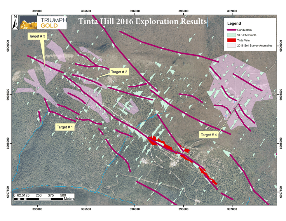
Four high-priority exploration targets have been identified based on geophysical patterns and coincident multielement (Au, Ag, Pb, Bi) geochemical anomalies that match those of the Tinta deposit:
- 1.Target 1 is located 450 metres to the northwest and along strike of the Tinta deposit. It is part of the same continuous VLF-EM conductor as the deposit. The target has a 630 metre strike length and includes highly anomalous concentrations of Au, Ag and Pb in soils. The geochemical anomaly is centered on an approximately 90-metre-long portion of the conductor axis where conductivity is low in the center but is flanked by broad weak to moderate conductivity, similar to the VLF-EM signature where the Tinta vein is thickest.
- 2.Target 2 is located approximately 150 metres north of the first target, where a second, oblique (280?) conductor is coincident with a Au, Ag, and Pb in soil geochemical anomaly over approximately 340 metres.
- 3.Target 3 is located 1.15 kilometres northwest of the Tinta deposit. It is coextensive with the intersection of the conductors that define targets one and two. The intersection is coincident with a strong Au, Ag, Pb and Bi in soil anomaly that covers an area of three hectares along and downslope of the conductors.
- 4.Target 4 is located 1.4 km to the north-northeast of the Tinta deposit, beyond the edge of current and historical soil geochemistry grids. This broad target area encompasses the intersections of at least three moderate to strong conductors.
The 2017 exploration program at Tinta Hill will include prospecting and trenching within the target areas. Further geophysical and in-fill geochemical surveys will be conducted to the north and northwest of the 2016 survey area.
Geochemical Sample Collection and Analytical Technique
Soil samples were collected at predetermined locations identified using a global positioning system. Samples were collected from B-horizon, or below the top layer of volcanic ash where B-horizon could not be sampled. The samples were characterized, dried, and delivered to ALS Minerals Preparation Laboratory in Whitehorse. Samples were analyzed using Au-ST43 (super trace Au determination via 25.0 g aqua regia digestion and ICP-MS analysis) and ME-MS41 (51 element analysis via 0.5 g aqua regia digestion and ICP-MS analysis).
Geophysical Data Collection Technique
Very low frequency electromagnetic (VLF-EM) and total magnetic field (TMF) data were collected along a 70 line-km grid using a station spacing of 12.5 m and 200 m line spacing with 50 m spaced infill lines over part of the grid. GEM Systems’ GSM–19 magnetometer + VLF + GPS and GSM-19 base station magnetometer were used to collect the data. VLF-EM data were collected from three VLF stations: frequency 24.0 kHz – Cultler, frequency 24.8 kHz – Jim Creek, and frequency 25.2 kHz – La Moure. The base station magnetometer was installed in a magnetically quiet area and cycled at 3s during the survey. Raw data was imported into a LibreOffice Calc spreadsheet and diurnal corrections were applied. Quality control ratings were assigned to each reading and only data flagged as “good” were selected for subsequent gridding and profiling.
About Triumph Gold Corp.
Triumph Gold Corp. is a growth oriented Canadian-based precious metals exploration and development company. Triumph Gold Corp. is focused on creating value through the advancement of the district scale Freegold Mountain project in Yukon. For maps and more information, please visit our website www.triumphgoldcorp.com
The reported geophysical and geochemical program was carried out by TerraLogic Exploration Inc. under the supervision of Michael McCaig (P.Geo). The technical content of this news release has been reviewed and approved by Tony Barresi, Ph.D., P.Geo, Vice President Exploration of the company and qualified person for the purposes of National Instrument 43-101 — Standards of Disclosure for Mineral Properties of the Canadian Securities Administrators.
On behalf of the Board of Directors
Signed “Paul Reynolds”
Paul Reynolds, President & CEO
For further information please contact:
John Anderson, Chairman
Triumph Gold Corp.
(604) 283-0896
janderson@triumphgoldcorp.com
Neither the TSX Venture Exchange nor its Regulation Services Provider (as that term is defined in policies of the TSX Venture Exchange) accepts responsibility for the adequacy or accuracy of this release.


