Nevada Sunrise Signs Option Agreements on Two Nevada Lithium Properties
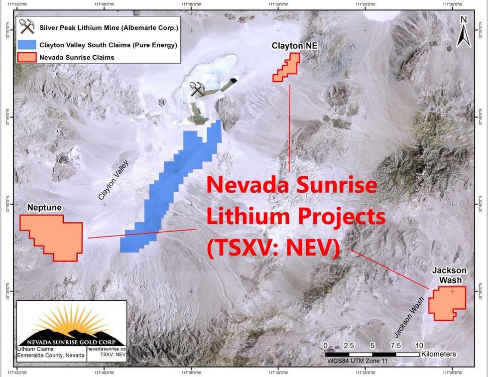
Nevada Sunrise Gold Corporation (TSXV:NEV) announced it has entered into interim letter agreements for an option to purchase two additional lithium exploration properties located in Esmeralda county, Nevada.
Nevada Sunrise Gold Corporation (TSXV:NEV) announced it has entered into interim letter agreements for an option to purchase two additional lithium exploration properties located in Esmeralda county, Nevada. The Company previously announced the acquisition of the Neptune lithium exploration property in the Clayton Valley area near Silver Peak, Nevada.
As quoted in the press release:
Clayton Northeast Property
The Clayton Northeast property (“Clayton NE”) consists of 16 unpatented association placer claims totaling 526 acres (213 hectares) contiguous to the Silver Peak lithium mine property (“Silver Peak”) operated by Albemarle Corporation. It is reported in the United States Geological Survey (“USGS”) Open-File Report 82-415 (1982) that a historical drill-hole (CV-5) is located on the property. CV-5 was drilled to a depth of 479 feet (146 metres) and encountered lithium values in ground water ranging from 24 parts per million (“ppm”) to 110 ppm, averaging 69.3 ppm for a group of 11 samples, and averaging 65.75 ppm for another group of 12 samples, analyzed both in the laboratory and in the field. The hole was part of a 1977 regional drilling program carried out by the USGS. Nevada Sunrise believes that drilling deeper holes at Clayton NE could intersect additional aquifers potentially hosting brines of similar or better contents of lithium than were encountered in the relatively shallow historical hole.
In 2013, the USGS released a paper describing the Clayton Valley’s potential to host lithium deposits based on the hypothesis that lithium is liberated by weathering of host rocks or derived from hydrothermal fluids from a variety of rock sources within a closed basin. The floor of Clayton Valley has an area of about 100 square kilometers and a catchment of about 1,400 square kilometres, and is the lowest (topographically) of at least five adjacent basins that are hydrologically linked by groundwater flow (Zampirro, 2004). It is the combined area of all five linked catchments that makes the effective area of the Clayton Valley lithium-brine system much larger than the footprint of the Clayton Valley proper (Source: from USGS Open File 13-1006, 2013).
Jackson Wash Property
The Jackson Wash property (“Jackson Wash”) consists of 58 unpatented association placer claims totaling approximately 2,215 acres (900 hectares) located approximately 20 miles (30 kilometers) southeast of Silver Peak on the east side of the Montezuma Range. Detailed gravity and electromagnetic investigations carried out in 2011 by a previous operator identified a layered sequence of interpreted saturated sedimentary formations filling a deep basin beneath Jackson Wash. Drilling and sampling of the sediments and groundwater in the interpreted basin are the next steps in the exploration process for Jackson Wash. Nevada Sunrise is currently reviewing all historic data, including a proposed four-hole drill program to test specific structural and stratigraphic targets believed prospective for brine deposits. This program was designed by the previous operator.
Jackson Wash lies in an adjacent valley to the southeast of the Clayton Valley demonstrating similar geological characteristics. It is considered to be prospective for hosting lithium-bearing brines within a discrete, deep basin, interpreted from the 2011 gravity and electromagnetic surveys carried out by a previous operator. Nevada Sunrise is not aware of any modern exploration or drilling for lithium-bearing brines at Jackson Wash.
Connect with Nevada Sunrise Gold Corporation (TSXV:NEV) to receive an Investor Kit.
