Fission 3.0 Drills Strong Alteration in Multiple Holes at Key Lake South
Fission 3.0 Corp (TSXV:FUU)(“Fission 3” or “the Company”) is pleased to announce results from the first pass drill program at its Key Lake South properties (Karpinka Lake and Hobo Lake projects) in the south-east Athabasca Basin region of Saskatchewan, Canada.
Fission 3.0 Corp (TSXV:FUU)(“Fission 3” or “the Company”) is pleased to announce results from the first pass drill program at its Key Lake South properties (Karpinka Lake and Hobo Lake projects) in the south-east Athabasca Basin region of Saskatchewan, Canada. A total of ~1300m was drilled in eight completed holes, all of which encountered variably intense hydrothermal alteration and six holes with anomalous radioactivity. Of note, holes KL19-005, KL19-006 and KL19-007, drilled in the northern part of the extensive land package, encountered the most significant hydrothermal alteration and paleoweathering, which are considered important factors for hosting high-grade uranium mineralization and will be prioritized for follow up. With $6M in the treasury, Fission 3 is well poised to continue to explore on its extensive property portfolio.
- Winter program at Key Lake complete: Eight holes in 1300.8m in the Key Lake South projects (Karpinka Lake and Hobo Lake) – located on the south-east region of the Athabasca Basin, 40 km south of the basin margin in a geological setting analogous to Fission Uranium’s Triple R deposit at PLS.
- Drilling intercepted multiple anomalous and narrow radiometric anomalies and strong alteration: drill holes located in the northern area of the property (holes KL19-005, KL19-006 and KL19-007) have exhibited the strongest hydrothermal alteration and paleoweathering profile.
- Prospective for high-grade mineralization: KL19-005 intersected over 100m of strong clay alteration and faulted rock, which is interpreted to represent a major structural dilation zone. Such settings are important in the genesis of structurally hosted uranium deposits as they provide a pathway for large amount of hydrothermal fluid flow and can develop traps for localizing mineralized fluids. Most of the Athabasca Basin’s major uranium deposits are situated in similar geological settings.
- Cree Bay exploration upcoming: Fission 3.0’s ongoing portfolio exploration program will now move to Cree Bay, conducting ground geophysics surveys to assist with the planned summer drill program.
Ross McElroy, COO, and Chief Geologist for Fission, commented,
“The drill program at Key Lake is the latest step in the ongoing exploration of our prospective uranium projects. With radioactivity and strong alteration in multiple holes, we are looking at very encouraging first pass results that warrant follow up drilling. The winter program will now progress with a ground geophysics DC resistivity survey on our Cree Bay property in the northeast basin area, as we focus on developing high-priority drill targets to be tested during the summer exploration program.”
About Key Lake South: The Key Lake area is an important historic mining district. The Key Lake operations is owned by Cameco Corp. (83%) and Orano Canada Inc. (17%) and hosted the former Key Lake mine, which produced 208 million pounds of uranium between 1975 to 1997 and is home to one of the largest uranium mills in the world. The Key Lake mill processed ore from the McArthur River uranium deposit, until Cameco announced in 2018 that McArthur River mining would be suspended indefinitely due to low uranium prices. The area is considered highly prospective to discover significant new uranium occurrences.
The 100% owned Key Lake South Projects consist of two projects (Karpinka Lake and Hobo Lake) covering 19,377 ha in 42 mineral claims. The properties are located approximately 40km south of the historic Key Lake mine. The projects are geologically situated within the extremely prolific Wollaston-Mudjatic Transition Zone “WMTZ”, notable for hosting the majority of the major high-grade uranium deposits on the eastern side of the Athabasca Basin. To the north, the Key Lake Deposit is hosted within the northern portion of northeast-southwest trending litho-structural feature known as the Key Lake Shear Zone “KLSZ”. The KLSZ continues southward through the Karpinka Lake and Hobo Lake projects. Together the properties cover approximately 50km of trend of the KLSZ, where a number of geochemical uranium anomalies have been discovered and where a network of EM conductors exhibit structural complexity including off-sets, breaks, folding and other geophysical features such as gravity and resistivity lows. These features are often associated with uranium mineralization occurrences.
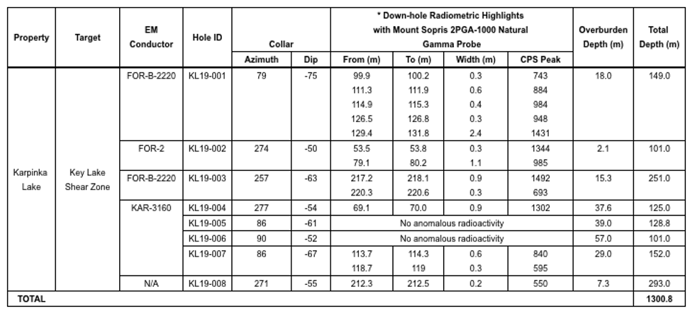
Key Lake South Projects – Drilling Summary
Table 1: Winter 2019 Key Lake South Drill Hole Summary
KL19-001
KL19-001 was an angled drill hole oriented parallel to the intermittent, weak, calc-silicate hosted radioactivity intersected in historic hole RO-01. The purpose of KL19-001 was to test the radioactive calc-silicate from the top of bedrock down to a depth of approximately 150m. Bedrock was intersected at a depth of 18.0m down hole and was comprised of variably clay, hematite, graphite and chlorite altered schist, cataclasite and calc-silicate. A strongly hematized calc-silicate was cored from 126.8m to 132.5m down hole which returned weak radioactivity up to 590 cps on a RS-125 handheld scintillometer. No other anomalous radioactivity was intersected, and the hole was terminated at a depth of 149.0m in weakly altered graphitic schist.
KL19-002
KL19-002 was an angled drill hole targeting the Key Lake Shear zone (KLSZ) approximately 950m south of KL19-001. Bedrock was intersected at a depth of 43.0 m down hole and was comprised of weakly altered orthogneiss and calc-silicate gneiss to a depth of 72.9m. From 72.9m to 80.3m a strongly sheared biotite-garnet gneiss was cored with a central 5.2m wide graphitic brittle-ductile fault zone. The hole was terminated at a depth of 101.0m in fresh orthogneiss.
KL19-003
KL19-003 was an angled drill hole targeting the weakly radioactive calc-silicate approximately 75m below that intersected in KL19-001. The drill hole aimed to assess the variability in previously intersected calc-silicate thickness and radioactivity with depth, and to test for parallel radioactive calc-silicate lenses. Bedrock was intersected at a depth of 15.3m down hole and was comprised of a thick sequence of biotite schist to a depth of 182.5m where a sheared, graphitic schist was intersected. A weakly radioactive calc-silicate lens was cored from 222.2m to 224.5m which returned up to 410 cps on a RS-125 handheld scintillometer. The hole was terminated at a final depth of 251.0m in fresh orthogneiss.
KL19-004
KL19-004 was an angled drill hole testing the southern extent of a large left stepping electromagnetic conductor trace ~7km north of KL-001. This flexure is interpreted to reflect a dilational zone in the KLSZ caused by sinistral strike-slip movement. Bedrock was intersected at a depth of 37.0m down hole and was comprised primarily of weakly hematite altered orthogneiss. An intercalacted sequence of weakly graphitic biotite-garnet schist and cataclasite was cored from 42.7m to 66.9m down hole. No anomalous radioactivity was intersected, and the hole was terminated at a depth of 125.0m in fresh orthogneiss.
KL19-005
KL19-005 was an angled drill hole testing the same large, left stepping KLSZ VTEM conductor trace as KL19-004, approximately 1 km further to the north. Bedrock was intersected at a depth of 39.0m down hole as was comprised of moderately to extremely bleached, clay, hematite, chlorite and graphite altered orthogneiss. A strongly graphitic, clay and chlorite altered cataclasite was intersected from 85.5m to 94.5m down hole. Thin limonitic fractures in the graphite altered orthogneiss at approximately 78m down hole returned elevated radioactivity up to 200 cps on the RS-125 handheld scintillometer. The hole was lost due to ground conditions at a depth of 128.8m in strongly chlorite and graphite altered orthogneiss.
KL19-006
KL19-006 was an angled drill hole testing the up-dip projection of the graphitic cataclasite in hole KL19-005. Bedrock was intersected at depth of 56.0m down hole and was comprised of weakly clay and chlorite altered orthogneiss. The drill hole is interpreted to have overshot the graphitic cataclasite which down-dropped the bedrock surface to the east (normal faulting). No anomalous radioactivity was intersected and the hole was terminated at a depth of 101.0m in weakly chlorite and clay altered orthogneiss.
KL19-007
KL19-007 was an angled drill hole testing the down-dip projection of the structural damage zone and strong alteration in KL19-005. Bedrock was intersected at a depth of 29.0m down hole and was comprised of extremely clay and chlorite altered graphitic cataclasite, variably altered graphitic schist, biotite schist and orthogneiss. Weak elevated radioactivity up to 160 cps was recorded on the RS-125 handheld scintillometer at 119.0m hosted in intercalated quartzitic and graphitic schist. Apart from the upper cataclasite no structural damage zone was intersected below KL19-005 and the hole was terminated at a depth of 152.0m in fresh orthogneiss.
KL19-008
KL19-008 was an angled drill hole testing for the northern extension of the historic DD-Zone where previous historic drilling returned up to 0.78% U3O8 over 0.5m. Bedrock was intersected at a depth of 7.3m down hole and was comprised of a thick intercalated sequence of graphite altered amphibolite and calc-silicate to a depth of 136.8m. Below 136.8m, the hole encountered weakly altered to fresh biotite-garnet schist and graphitic schist. A 0.20m granite intrusion at 90.5 m depth returned elevated radioactivity up to 540 cps. The hole was terminated at a depth of 293.0min fresh biotite-garnet schist.
Natural gamma radiation in drill core that is reported in this news release was measured in counts per second (cps) using a Mount Sopris PGA-1000 Natural Gamma Probe and a hand-held RS-125 Scintillometer manufactured by Radiation Solutions. The reader is cautioned that scintillometer readings are not directly or uniformly related to uranium grades of the rock sample measured and should be used only as a preliminary indication of the presence of radioactive materials.
Samples from the drill core are split in half sections on site. Where possible, samples are standardized at 0.5m down-hole intervals. One-half of the split sample will be sent to SRC Geoanalytical Laboratories (an SCC ISO/IEC 17025: 2005 Accredited Facility) in Saskatoon, SK. Analysis will include a 63 element ICP-OES, and boron.
All depth measurements reported, including radioactivity and mineralization interval widths are down-hole, core interval measurements and true thickness are yet to be determined.
Cree Bay Exploration: In 2017 a ground DC Resistivity survey was completed in 2 separate grids centered on sections of strong conductivity interpreted from a historic airborne GEOTEM electromagnetic survey on what was then the Cree Bay property. Fission 3 subsequently staked additional ground to cover the most conductive part of this anomaly. The winter 2019 exploration work will thus continue to extend the ground geophysics survey over the anomaly, to determine the highest priority drill targets. The program will consist of a winter 21 line-km ground DC Resistivity survey and 2 lines of Moving Loop TDEM survey will be conducted during April to cover the most geophysically prospective area identified from a historic GEOTEM electromagnetic survey.
About Cree Bay: The Cree Bay property, located 20km south of the town of Stony Rapids, consists of 16 claims totaling 14,080 ha and sits on the inside edge of the north-eastern Athabasca Basin. The property is located along the major SW-NE trending Virgin River Shear Zone. Locally the conductive corridor is bound by the Black Lake Fault to the north and East Channel Fault to the south. The historic Nisto uranium mine, is located ~7.5km to the northeast, along the Black Lake fault.
The technical information in this news release has been prepared in accordance with the Canadian regulatory requirements set out in National Instrument 43-101 and reviewed on behalf of the company by Ross McElroy, P.Geol. Chief Geologist and COO for Fission 3.0 Corp., a qualified person.
About Fission 3.0 Corp.
Fission 3.0 Corp. is a Canadian based resource company specializing in the strategic acquisition, exploration and development of uranium properties and is headquartered in Kelowna, British Columbia. Common Shares are listed on the TSX Venture Exchange under the symbol “FUU.”
ON BEHALF OF THE BOARD
“Ross McElroy”
Ross McElroy, COO
Cautionary Statement: Certain information contained in this press release constitutes “forward-looking information”, within the meaning of Canadian legislation. Generally, these forward-looking statements can be identified by the use of forward-looking terminology such as “plans”, “expects” or “does not expect”, “is expected”, “budget”, “scheduled”, “estimates”, “forecasts”, “intends”, “anticipates” or “does not anticipate”, or “believes”, or variations of such words and phrases or state that certain actions, events or results “may”, “could”, “would”, “might” or “will be taken”, “occur”, “be achieved” or “has the potential to”. Forward looking statements contained in this press release may include statements regarding the future operating or financial performance of Fission 3.0 Corp. which involve known and unknown risks and uncertainties which may not prove to be accurate. Actual results and outcomes may differ materially from what is expressed or forecasted in these forward-looking statements. Such statements are qualified in their entirety by the inherent risks and uncertainties surrounding future expectations. Among those factors which could cause actual results to differ materially are the following: market conditions and other risk factors listed from time to time in our reports filed with Canadian securities regulators on SEDAR at www.sedar.com. The forward-looking statements included in this press release are made as of the date of this press release and Fission 3 Corp. disclaim any intention or obligation to update or revise any forward-looking statements, whether as a result of new information, future events or otherwise, except as expressly required by applicable securities legislation.
For further information: Investor Relations, Ph: 778-484-8030, TF: 844-484-8030, ir@fission3corp.com, www.fission3corp.com
Click here to connect with Fission 3.0 Corp (TSXV:FUU) for an Investor Presentation.
Source: www.newswire.ca
