Forum Commences Gravity and Soil Surveys for Follow-Up Drilling at Fir Island, Athabasca Basin
VANCOUVER, BC–(Marketwired – August 09, 2016) – Forum Uranium Corp. (TSXV:FDC) has commenced ground gravity and soil sampling surveys on its 100% owned Fir Island Project to define drill targets along the East Channel Structural Corridor.
VANCOUVER, BC–(Marketwired – August 09, 2016) – Forum Uranium Corp. (TSXV:FDC) has commenced ground gravity and soil sampling surveys on its 100% owned Fir Island Project to define drill targets along the East Channel Structural Corridor. Five holes from the 2015 drill program encountered intense alteration (quartz dissolution, dravite, hydrothermal hematite and sudoite alteration minerals) within sandstones over a major structural lineament with a 50m vertical offset of the unconformity. The sandstone cover to the unconformity with basement rocks is shallow, varying from surface (0m) to a depth of 200 metres on the Fir Island property. The East Channel trend occurs for over 18 kilometres on Forum’s property and the 2015 winter drill program tested only 50 metres of this strike length.
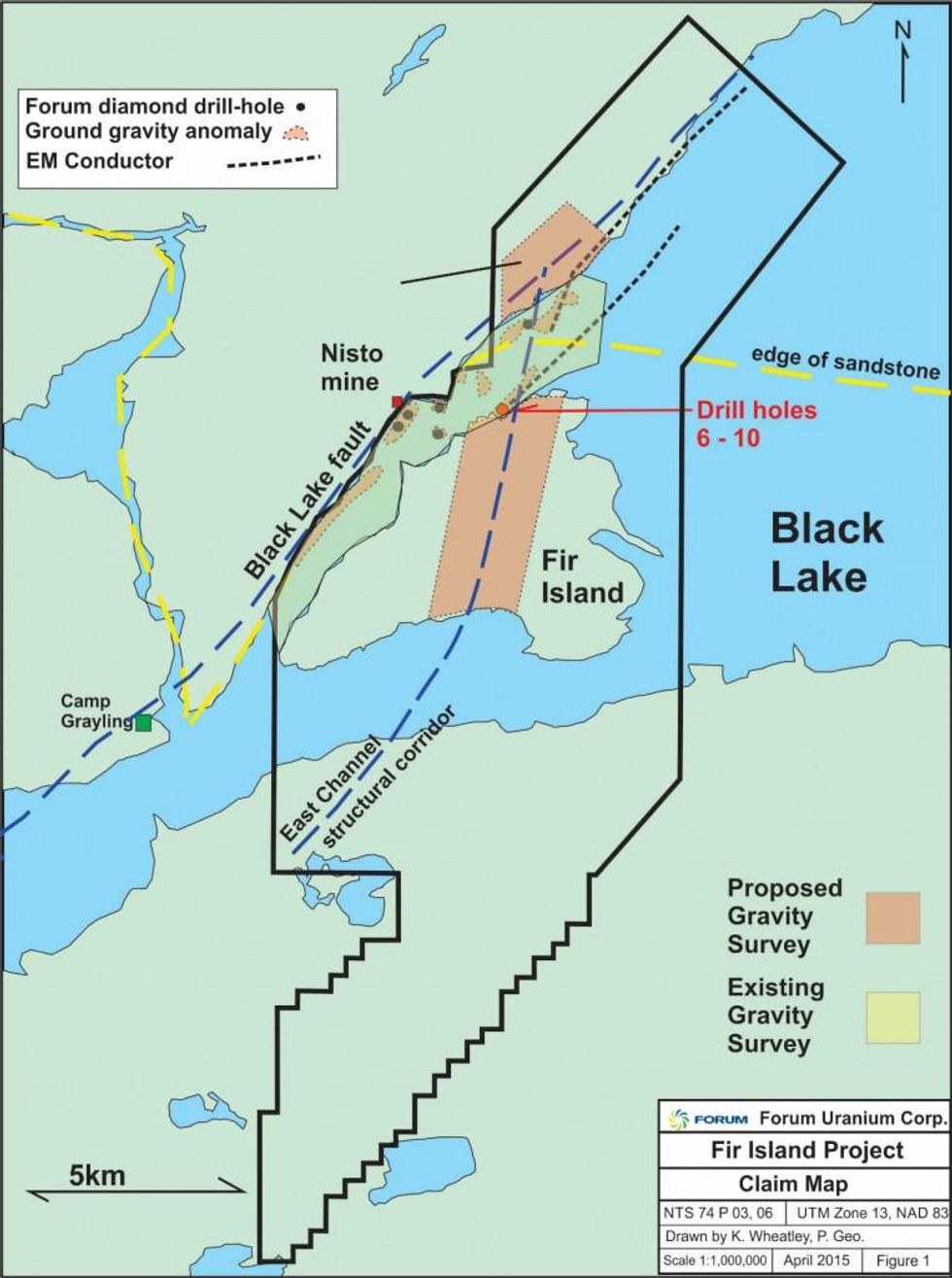
The gravity and soil surveys will cover approximately 5 kilometres of the East Channel Trend on Fir Island and along the Black Bay Fault/East Channel intersection. Gravity measurements will be taken at stations 100 metres apart along lines spaced at 100 metre intervals to identify areas of low gravity (possible clay-rich alteration) favourable for uranium mineralization for future drilling. The soil survey will be conducted for analysis of uranium and other geochemical pathfinder elements such as boron, concentrating on areas down-ice of the gravity lows.
The parallel Black Lake structure, located 1.5 kilometres to the west, is part of the Snowbird Tectonic Zone that can be traced for at least 200 kilometres across the entire Athabasca Basin and is associated with Cameco’s Centennial deposit with intersections of up to 33.9 metres averaging 8.78% U3O8 (Source: Formation Metals website). This major structural zone exhibits similarities to the Wollaston-Mudjatik tectonic zone that hosts 16% of world uranium production, but remains relatively underexplored.
Figure 1: Map of the Fir Island Project. Claims are outlined in black. Both the Black Lake fault and the East Channel are wide structural zones. The Black Lake fault has numerous uranium showings along it, while the East Channel has only been tested with five holes to date. The proposed soil sampling program will be conducted along the west side of the gravity survey. Ice direction in this area is from east to west.
Connect with Forum Uranium Corp. (TSXV:FDC) to receive an Investor Presentation.
