The Conversation (0)
Tempus Resources Ltd. is pleased to announce that it has received assays from the first 11 successfully completed drill-holes of the Phase 1 drilling program on the Elizabeth sector of the Blackdome Elizabeth Gold Project. HIGHLIGHTS: 5 drill-holes with significant intersections >5gt gold Outstanding intersections included: EZ-20-06: 5.0m at 61.3gt gold from 116.5m, including 1.5m at 186.0gt gold from 118.0m …
Tempus Resources Ltd. (ASX: TMR) (TSXV: TMRR) (“Tempus Resources” or the “Company”) is pleased to announce that it has received assays from the first 11 successfully completed drill-holes of the Phase 1 drilling program on the Elizabeth sector of the Blackdome Elizabeth Gold Project.
HIGHLIGHTS:
- 5 drill-holes with significant intersections >5g/t gold
Outstanding intersections included:
EZ-20-06: 5.0m at 61.3g/t gold from 116.5m, including 1.5m at 186.0g/t gold from 118.0m
EZ-20-10: 3.2m at 28.1g/t gold from 184.0m, including 0.5m at 178.0g/t gold from 184.5m
Drilling at Elizabeth to re-commence to complete remaining two thirds of Phase 1 drilling program during the Canadian spring
Tempus Resources President, Jason Bahnsen, commented “The Phase 1 drilling results confirm the high-grade potential of Elizabeth. We look forward to continuing with the drilling program there in the Canadian spring, leading to an updated NI43-101 resource estimate thereafter.”
11 diamond drill holes, for a total of 2,006 meters, were successfully completed of the total 6,000 meter Phase 1 drilling program on the Elizabeth sector of the Blackdome Elizabeth Gold Project. The drilling was completed from mid-November to mid-December 2020. The primary focus of this initial drilling was infill and down dip extension at the southern portion of the Southwest (SW) Vein and a single drill-hole testing the extension of the West and Main veins (see Figures 1 and 2).
The 10 holes with reportable intersections provided the following results.*
- EZ-20-01
- 1.20m at 0.62g/t gold and 3.12g/t silver from 52.4m
- EZ-20-04
- 3.02m at 5.26g/t gold and 7.51g/t silver from 101.5m, including:
- 1.70m at 9.74g/t gold and 3.88g/t silver from 103.0m
- 3.02m at 5.26g/t gold and 7.51g/t silver from 101.5m, including:
- EZ-20-05
- 0.60m at 0.27g/t gold and 0.13g/t silver from 175.9m
- EZ-20-06
- 5.00m at 61.3g/t gold and 44.5g/t silver from 116.5m, including:
- 1.50m at 186.0g/t gold and 133.0g/t silver from 118.0m
- 5.00m at 61.3g/t gold and 44.5g/t silver from 116.5m, including:
- EZ-20-07
- 1.50m at 9.60g/t gold and 0.70g/t silver from 71.0m
- 1.00m at 8.09g/t gold and 1.40g/t silver from 155.0m
- EZ-20-08
- 2.00m at 1.80g/t gold and 2.96g/t silver from 86.0m
- 2.00m at 2.54g/t gold and 0.89g/t silver from 92.0m
- EZ-20-09
- 1.70m at 0.59g/t gold and 0.50g/t silver from 77.0m
- 0.55m at 0.86g/t gold and 4.75g/t silver from 190.7m
- EZ-20-10
- 2.00m at 1.20g/t gold and 1.19g/t silver from 107.0m
- 3.20m at 28.1g/t gold and 4.74g/t silver from 184.0m, including:
- 0.50m at 178.0g/t gold and 27.0g/t silver from 184.5m
- 0.55m at 1.20g/t gold and 1.35g/t silver from 198.2m
- EZ-20-11
- 3.00m at 0.15g/t gold and 0.36g/t silver from 73.0m
- 0.50m at 0.52g/t gold and 0.92g/t silver from 269.0m
- EZ-20-12
- 3.70m at 3.73g/t gold and 1.95g/t silver from 52.0m, including
- 2.00m at 5.60g/t gold and 2.95g/t silver from 52.0m
- 2.00m at 0.61g/t gold and 2.55g/t silver from 63.0m
- 3.70m at 3.73g/t gold and 1.95g/t silver from 52.0m, including
* Note: No significant intersections were returned from drill-hole EZ-20-03.
Intersection widths are down hole widths, true width estimates are shown in Appendix 1 – Table 2.
There are approximately 4,000 meters of drilling remaining in the Elizabeth Phase 1 drilling program. Tempus expects to re-commence drilling and complete the remaining program in the Canadian spring. Given the early success of the Phase 1 drilling program, it will be immediately followed by: preparation of an updated NI43-101 Mineral Resource estimate; and an additional 7,500 meter Phase 2 program focused on delineation of additional resources at the Southwest, Main and West Veins as well as untested soil geochemistry targets identified in previous years.
Tempus is very encouraged by the first tranche, Phase 1 results at the Elizabeth Project. These results increase the confidence level of the geological model that will be utilized for resource estimation work over the coming year.
The Elizabeth Phase 1 high-grade intercepts are consistent with historic values previously reported, including 331 g/t gold over 95 cm (E07-43), and visible gold that was identified in drill hole EZ-20-06 as announced in a Tempus Resources press Release on December 15, 2020 which returned values up to 186g/t gold over 1.5 meters.
The high-grade gold mineralization in the SW Vein has only been defined to shallow depths (~200m) and along a strike length of approximately 400m however distant drill holes along trend indicate the SW Vein may extend along strike to the northeast an additional 400m for total strike of 800m.

Figure 1– Elizabeth Project Veins and 2020 Drilling
To view an enhanced version of this graphic, please visit:
https://orders.newsfilecorp.com/files/7585/73876_e0c9f18294999a22_001full.jpg
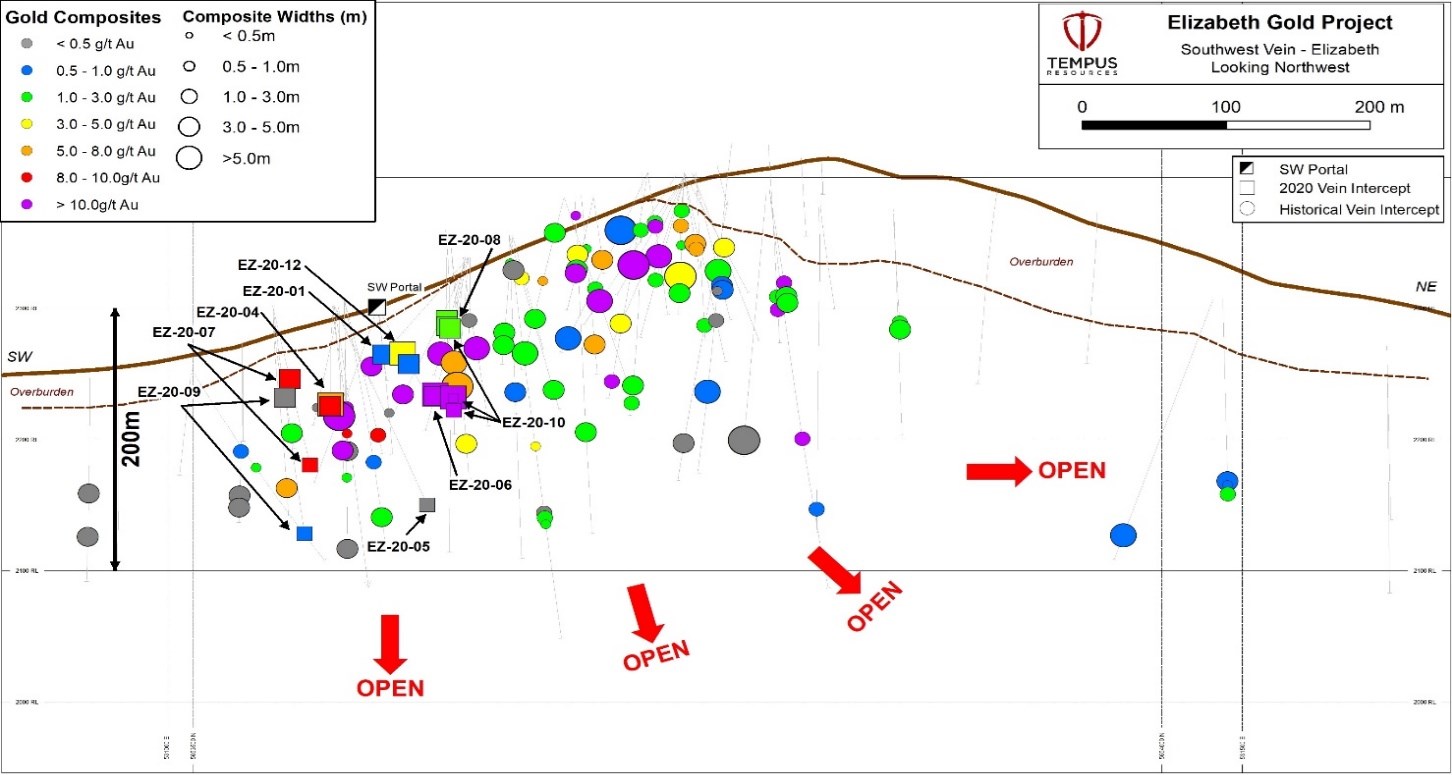
Figure 2– Elizabeth Project Southwest Vein Longitudinal Section
To view an enhanced version of this graphic, please visit:
https://orders.newsfilecorp.com/files/7585/73876_e0c9f18294999a22_002full.jpg
The Main and West Veins were explored by underground drifts in the 1940’s and 50’s and have only seen minimal exploration since. EZ-20-11 is a significant step out to the southwest (~300m) of the West and Main vein and was successful in intersecting both veins. Although width and grade were low the alteration and associated mineralization indicate these to be the continuation of the West and Main vein. Tempus believes these veins warrant follow up exploration as it indicates continuity of the veins over a greater strike length.
This announcement has been authorised by the Board of Directors of Tempus Resources Limited.
Competent Persons Statement
Information in this report relating to Exploration Results is based on information reviewed by Mr. Kevin Piepgrass, who is a Member of the Association of Professional Engineers and Geoscientists of the province of BC (APEGBC), which is a recognised Professional Organisation (RPO), and an employee of Tempus Resources. Mr. Piepgrass has sufficient experience which is relevant to the style of mineralisation and type of deposit under consideration and to the activity which he is undertaking to qualify as a Competent Person as defined by the 2012 Edition of the Australasian Code for reporting of Exploration Results, Mineral Resources and Ore Reserves, and as a Qualified Person for the purposes of NI43-101. Mr. Piepgrass consents to the inclusion of the data in the form and context in which it appears.
For further information:
TEMPUS RESOURCES LTD
Melanie Ross – Director/Company Secretary Phone: +61 8 6188 8181
About Tempus Resources Ltd
Tempus Resources Ltd (“Tempus”) is a growth orientated gold exploration company listed on ASX (“TMR”) and TSX.V (“TMRR”) stock exchanges. Tempus is actively exploring projects located in Canada and Ecuador. The flagship project for Tempus is the Blackdome-Elizabeth Project, a high grade gold past producing project located in Southern British Columbia. Tempus is currently midway through a drill program at Blackdome-Elizabeth that will form the basis of an updated NI43-101/JORC resource estimate leading to a PEA study in 2021. The second key group of projects for Tempus are the Rio Zarza and Valle del Tigre projects located in south east Ecuador. The Rio Zarza project is located adjacent to Lundin Gold’s Fruta del Norte project. The Valle del Tigre project is currently subject to a sampling program to develop anomalies identified through geophysical work.
Forward-Looking Information and Statements
This press release contains certain “forward-looking information” within the meaning of applicable Canadian securities legislation. Such forward-looking information and forward-looking statements are not representative of historical facts or information or current condition, but instead represent only the Company’s beliefs regarding future events, plans or objectives, many of which, by their nature, are inherently uncertain and outside of Tempus’s control. Generally, such forward-looking information or forward-looking statements can be identified by the use of forward-looking terminology such as ”plans”, ”expects” or “does not expect”, “is expected”, “budget”, “scheduled”, “estimates”, “forecasts”, “intends”, ”anticipates” or “does not anticipate”, or “believes”, or variations of such words and phrases or may contain statements that certain actions, events or results “may”, “could”, “would”, “might” or “will be taken”, “will continue”, ”will occur” or “will be achieved”. The forward-looking information and forward-looking statements contained herein may include, but are not limited to, the continuation of drilling in the Spring of 2021, the receipt of the analysis and assay results from the lab early in 2021, the ability of Tempus to successfully achieve business objectives, and expectations for other economic, business, and/or competitive factors. Forward-looking statements and information are subject to various known and unknown risks and uncertainties, many of which are beyond the ability of Tempus to control or predict, that may cause Tempus’ actual results, performance or achievements to be materially different from those expressed or implied thereby, and are developed based on assumptions about such risks, uncertainties and other factors set out herein and the other risks and uncertainties disclosed under the heading “Risk Factors” in the Company’s listing application dated December 3, 2020 filed on SEDAR. Should one or more of these risks, uncertainties or other factors materialize, or should assumptions underlying the forward-looking information or statements prove incorrect, actual results may vary materially from those described herein as intended, planned, anticipated, believed, estimated or expected. Although Tempus believes that the assumptions and factors used in preparing, and the expectations contained in, the forward-looking information and statements are reasonable, undue reliance should not be placed on such information and statements, and no assurance or guarantee can be given that such forward-looking information and statements will prove to be accurate, as actual results and future events could differ materially from those anticipated in such information and statements. The forward-looking information and forward-looking statements contained in this press release are made as of the date of this press release, and Tempus does not undertake to update any forward-looking information and/or forward-looking statements that are contained or referenced herein, except in accordance with applicable securities laws. All subsequent written and oral forward-looking information and statements attributable to Tempus or persons acting on its behalf is expressly qualified in its entirety by this notice.
Neither the TSX Venture Exchange nor its Regulation Service Provider (as that term is defined in the policies of the TSX Venture Exchange) accepts responsibility for the adequacy or accuracy of this release.
Appendix 1
Table 1:Drill Hole Collar Table
| Hole ID | Target | UTM Easting (NAD83 Z10) | UTM Northing (NAD83 Z10) | Elevation (m) | Length | Azimuth | Dip |
| EZ-20-01 | SW Vein | 531088 | 5653604 | 2302 | 80 | 125.2 | -45 |
| EZ-20-02 | SW Vein | 531088 | 5653604 | 2302 | 83 | 107 | -45 |
| EZ-20-03 | SW Vein | 531044 | 5653603 | 2302 | 128 | 122.8 | -45 |
| EZ-20-04 | SW Vein | 531044 | 5653603 | 2302 | 125 | 140.1 | -50 |
| EZ-20-05 | SW Vein | 531044 | 5653603 | 2302 | 180 | 82.3 | -60 |
| EZ-20-06 | SW Vein | 531120 | 5653660 | 2339 | 147 | 157.8 | -65 |
| EZ-20-07 | SW Vein | 530986 | 5653598 | 2302 | 150 | 116.5 | -52 |
| EZ-20-08 | SW Vein | 531030 | 5653720 | 2360 | 309 | 130.5 | -54 |
| EZ-20-09 | SW Vein | 530986 | 5653598 | 2302 | 195 | 116.5 | -65 |
| EZ-20-10 | SW Vein | 531030 | 5653720 | 2360 | 222 | 127.7 | -45 |
| EZ-20-11 | West Vein | 531281 | 5653599 | 2300 | 303 | 100.1 | -45 |
| EZ-20-12 | SW Vein | 531088 | 5653604 | 2302 | 84 | 104.6 | -45 |
Table 2: Significant Interval Table
| Hole ID | From (m) | To (m) | Interval (m) | True Thickness (m) | Gold Grade | Silver Grade | Grade x Metres | Vein |
| EZ-20-01 | 52.4 | 53.6 | 1.20 | 0.62 | 3.12 | 1 | SW Vein | |
| EZ-20-02 | Hole Lost | 0 | SW Vein | |||||
| EZ-20-03 | NSI | 0 | SW Vein | |||||
| EZ-20-04 | 101.5 | 104.7 | 3.20 | 2.45 | 5.26 | 7.51 | 17 | SW Vein |
| including | 103.0 | 104.7 | 1.70 | 1.30 | 9.74 | 3.88 | 17 | SW Vein |
| EZ-20-05 | 175.9 | 176.5 | 0.60 | 0.50 | 0.27 | 0.13 | 0 | SW Vein |
| EZ-20-06 | 116.5 | 121.5 | 5.00 | 3.83 | 61.3 | 44.5 | 307 | SW Vein |
| including | 118.0 | 119.5 | 1.50 | 1.15 | 186 | 133 | 279 | SW Vein |
| EZ-20-07 | 71.0 | 72.5 | 1.50 | 1.15 | 9.60 | 0.70 | 14 | SW Vein |
| and | 155.0 | 156.0 | 1.00 | 0.77 | 8.09 | 1.40 | 8 | SW Vein |
| EZ-20-08 | 86.0 | 88.0 | 2.00 | 1.15 | 1.80 | 2.96 | 4 | SW Vein |
| and | 92.0 | 94.0 | 2.00 | 1.15 | 2.54 | 0.89 | 5 | SW Vein |
| EZ-20-09 | 77.0 | 78.7 | 1.70 | 0.35 | 0.59 | 0.50 | 1 | SW Vein |
| and | 190.7 | 191.2 | 0.55 | 0.27 | 0.86 | 4.75 | 0 | SW Vein |
| EZ-20-10 | 107.0 | 109.0 | 2.00 | 1.53 | 1.20 | 1.19 | 2 | SW Vein |
| and | 184.0 | 187.2 | 3.20 | 2.45 | 28.1 | 4.74 | 90 | SW Vein |
| including | 184.5 | 185.0 | 0.50 | 0.38 | 178 | 27.0 | 89 | SW Vein |
| and | 198.2 | 198.7 | 0.55 | 0.45 | 1.20 | 1.35 | 1 | SW Vein |
| EZ-20-11 | 73.0 | 76.0 | 3.00 | 2.30 | 0.15 | 0.36 | 0 | West Vein |
| and | 269.0 | 269.5 | 0.50 | 0.38 | 0.52 | 0.91 | 0 | Main Vein |
| EZ-20-12 | 52.0 | 55.7 | 3.70 | 2.95 | 3.73 | 1.95 | 14 | SW Vein |
| including | 52.0 | 54.0 | 2.00 | 1.60 | 5.60 | 2.95 | 11 | SW Vein |
| and | 63.0 | 65.0 | 2.00 | 1.60 | 0.61 | 2.55 | 1 | SW Vein |
Table 3: Historic Intervals
| Hole ID | From (m) | To (m) | Length (m) | Au [ppm] | Vein | Grade x Metres |
| E04-08 | 89.50 | 95.30 | 5.80 | 5.06 | SW | 29 |
| E04-09 | 140.30 | 143.30 | 3.00 | 5.18 | SW | 16 |
| E04-10 | 88.75 | 93.20 | 4.45 | 40.5 | SW | 180 |
| including | 89.80 | 90.45 | 0.65 | 258 | SW | 168 |
| E04-11A | 110.24 | 111.24 | 1.00 | 18.3 | SW | 18 |
| E05-19 | 17.65 | 17.95 | 0.30 | 68.0 | SW | 20 |
| E05-19 | 49.21 | 50.90 | 1.69 | 3.70 | SW | 6 |
| E05-22 | 82.10 | 84.12 | 2.02 | 3.87 | SW | 8 |
| E05-26 | 36.40 | 37.00 | 0.60 | 4.96 | SW | 3 |
| E05-29 | 136.00 | 138.90 | 2.90 | 26.8 | SW | 78 |
| including | 136.92 | 137.80 | 0.88 | 87.3 | SW | 77 |
| E05-31 | 67.36 | 68.88 | 1.52 | 5.54 | SW | 8 |
| E05-31 | 72.00 | 73.00 | 1.00 | 6.35 | SW | 6 |
| E05-32 | 70.50 | 73.50 | 3.00 | 4.92 | SW | 15 |
| including | 71.50 | 72.50 | 1.00 | 9.35 | SW | 9 |
| E07-40 | 81.45 | 81.95 | 0.50 | 5.62 | SW | 3 |
| E07-40 | 150.04 | 154.94 | 4.90 | 1.41 | SW | 7 |
| E07-42 | 74.53 | 82.35 | 7.82 | 7.00 | SW | 55 |
| including | 78.90 | 80.90 | 2.00 | 17.5 | SW | 35 |
| E07-43 | 83.10 | 95.53 | 12.43 | 33.8 | SW | 420 |
| including | 85.05 | 86.00 | 0.95 | 331 | SW | 314 |
| including | 88.10 | 88.85 | 0.75 | 39.6 | SW | 30 |
| including | 92.28 | 93.20 | 0.92 | 10.4 | SW | 10 |
| including | 93.20 | 94.13 | 0.93 | 6.17 | SW | 6 |
| including | 94.13 | 95.53 | 1.40 | 29.7 | SW | 42 |
| E07-44 | 117.86 | 122.39 | 4.53 | 10.5 | SW | 48 |
| including | 120.26 | 121.53 | 1.27 | 24.7 | SW | 31 |
| E07-45 | 128.90 | 130.65 | 1.75 | 3.15 | SW | 6 |
| E07-47 | 103.90 | 105.80 | 1.90 | 2.93 | SW | 6 |
| E07-48 | 97.85 | 101.09 | 3.24 | 12.4 | SW | 40 |
| E07-50 | 99.10 | 103.93 | 4.83 | 7.15 | SW | 35 |
| including | 99.10 | 100.25 | 1.15 | 21.3 | SW | 24 |
| E10-51 | 176.50 | 178.13 | 1.63 | 4.8 | SW | 8 |
| E10-52 | 51.91 | 52.82 | 0.91 | 135 | SW | 123 |
| E10-54 | 65.16 | 67.16 | 2.00 | 7.24 | SW | 14 |
| including | 66.71 | 67.16 | 0.45 | 27.3 | SW | 12 |
| E10-55 | 70.24 | 76.10 | 5.86 | 6.01 | SW | 35 |
| including | 75.12 | 76.10 | 0.98 | 26.3 | SW | 26 |
| E10-58 | 225.61 | 226.25 | 0.64 | 29.1 | SW | 19 |
| E10-59 | 91.41 | 93.57 | 2.16 | 22.1 | SW | 48 |
| including | 91.93 | 92.75 | 0.82 | 57.5 | SW | 47 |
| E10-60 | 202.64 | 204.58 | 1.94 | 5.60 | SW | 11 |
| including | 203.60 | 204.10 | 0.50 | 12.8 | SW | 6 |
| E10-65 | 105.77 | 112.46 | 6.69 | 6.50 | SW | 43 |
| including | 105.77 | 106.25 | 0.48 | 70.6 | SW | 34 |
| E10-66 | 122.28 | 125.00 | 2.72 | 10.8 | SW | 29 |
| including | 122.78 | 123.32 | 0.54 | 44.2 | SW | 24 |
| E10-67 | 117.00 | 122.00 | 5.00 | 54.9 | SW | 275 |
| including | 118.50 | 119.00 | 0.50 | 64.9 | SW | 32 |
| including | 119.00 | 119.50 | 0.50 | 444 | SW | 222 |
| including | 119.50 | 120.00 | 0.50 | 34.6 | SW | 17 |
| E10-69 | 95.07 | 100.56 | 5.49 | 71.3 | SW | 391 |
| including | 95.07 | 96.10 | 1.03 | 50.7 | SW | 52 |
| including | 96.10 | 97.10 | 1.00 | 230 | SW | 230 |
| including | 97.10 | 97.64 | 0.54 | 120 | SW | 65 |
| including | 97.64 | 98.05 | 0.41 | 7.87 | SW | 3 |
| including | 98.05 | 99.09 | 1.04 | 18.1 | SW | 19 |
| including | 99.09 | 100.13 | 1.04 | 21.6 | SW | 22 |
| E11-03 | 117.37 | 117.87 | 0.50 | 9.12 | SW | 5 |
| E11-05 | 122.00 | 125.03 | 3.03 | 19.1 | SW | 58 |
| including | 122.54 | 123.03 | 0.49 | 11.0 | SW | 5 |
| including | 123.03 | 123.51 | 0.48 | 11.3 | SW | 5 |
| including | 123.51 | 124.00 | 0.49 | 95.3 | SW | 47 |
| E11-07 | 165.49 | 166.64 | 1.15 | 6.96 | SW | 8 |
| E11-U107 | 179.74 | 180.41 | 0.67 | 10.5 | SW | 7 |
| E04-01 | 80.50 | 105.55 | 25.05 | 0.88 | Listwanite | 22 |
| E04-15 | 9.14 | 30.00 | 20.86 | 0.51 | Listwanite | 11 |
| E11-20 | 21.63 | 23.00 | 1.37 | 2.00 | No.9 Vein | 3 |
| DDH 84-1 | 95.59 | 95.80 | 0.21 | 37.7 | No.9 Vein | 8 |
| DDH 84-2 | 88.39 | 89.00 | 0.61 | 7.13 | No.9 Vein | 4 |
| DDH 87-1 | 200.25 | 201.17 | 0.92 | 4.18 | No.9 Vein | 4 |
| DDH 87-4 | 64.47 | 65.01 | 0.54 | 4.94 | No.9 Vein | 3 |
| DDH 90-1 | 109.15 | 110.64 | 1.49 | 2.02 | No.9 Vein | 3 |
| E11-U101 | 91.78 | 94.35 | 2.57 | 1.20 | main | 3 |
| E11-U102 | 80.85 | 82.42 | 1.57 | 2.27 | main | 4 |
| E11-U98 | 48.95 | 50.10 | 1.15 | 8.10 | main | 9 |
| E11-U98 | 53.70 | 54.20 | 0.50 | 7.17 | main | 4 |
| E11-U107 | 240.74 | 241.72 | 0.98 | 4.94 | SW | 5 |
| E02-02 | 44.25 | 47.55 | 3.30 | 10.1 | West | 33 |
| E02-03 | 57.75 | 58.85 | 1.10 | 2.40 | West | 3 |
| E02-10 | 39.70 | 41.90 | 2.20 | 2.00 | West | 4 |
| E11-U80 | 90.56 | 91.16 | 0.60 | 9.15 | west | 5 |
| E11-U84 | 90.37 | 91.05 | 0.68 | 4.88 | west | 3 |
| E11-U93 | 35.00 | 35.60 | 0.60 | 7.22 | west | 4 |
Appendix 2: The following tables are provided to ensure compliance with the JORC Code (2012) requirements for the reporting of Exploration Results for the Blackdome-Elizabeth Gold Project
Section 1: Sampling Techniques and Data
(Criteria in this section apply to all succeeding sections.)
Criteria | JORC Code explanation | Commentary |
Sampling techniques |
|
|
Drilling techniques |
|
|
Drill sample recovery |
|
|
Criteria | JORC Code explanation | Commentary |
Logging |
|
|
Sub-sampling techniques and sample preparation |
|
|
Quality of assay data and laboratory tests |
|
|
Verification of sampling and assaying |
|
|
Criteria | JORC Code explanation | Commentary |
Location of data points |
|
|
Data spacing and distribution |
|
|
Orientation of data in relation to geological structure |
|
|
Sample security |
|
|
Audits or reviews |
|
|
Section 2: Reporting of Exploration Results
(Criteria listed in the preceding section also apply to this section.)
Criteria | JORC Code explanation | Commentary |
Mineral tenement and land tenure status |
|
|
Exploration done by other parties |
|
|
Criteria | JORC Code explanation | Commentary |
Geology |
|
|
Criteria | JORC Code explanation | Commentary |
Drill hole Information |
|
|
Data aggregation methods |
|
|
Relationship between mineralisation widths and intercept lengths |
|
|
Diagrams |
|
|
Criteria | JORC Code explanation | Commentary |
Balanced reporting |
|
|
Other substantive exploration data |
|
|
Further work |
|
|
![]()
To view the source version of this press release, please visit https://www.newsfilecorp.com/release/73876
News Provided by Newsfile via QuoteMedia
TMRR:CA