October 02, 2024
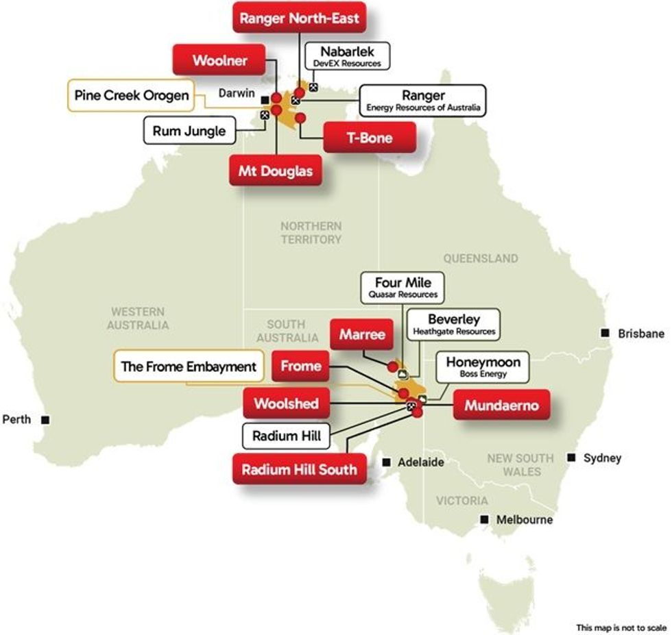
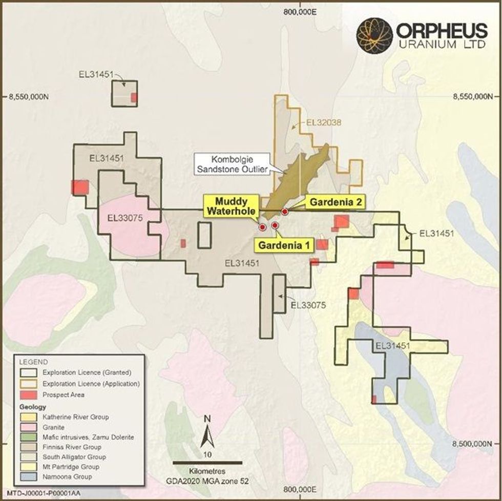
Orpheus Uranium Limited (ASX: ORP) (Orpheus or the Company) is pleased to announce that on-ground exploration activities have commenced within the Company’s Mt Douglas Project in the Northern Territory (see Figure 1 & Figure 2).
Highlights
- Geological reconnaissance and sampling have commenced at Mount Douglas (NT) targeting unconformity-style uranium mineralisation similar to other uranium deposits in the Pine Creek Orogen.
- Initial focus on airborne and surface radiometric anomalies coincident with structures.
- Localised gravity survey to be completed in collaboration with the NTGS/Geoscience Australia’s regional gravity survey planned for commencement in 2024.
- Approval received from the Northern Territory Government for a Mining Management Plan (MMP) allowing Orpheus to undertake advance-stage exploration activities at Mt Douglas.
The exploration program will “ground truth” extensive anomalies within the project defined from historical airborne and surface radiometric surveys (see Figure 3). The program will include geological mapping and systematic rock chip sampling to identify zones of potential primary uranium mineralisation.
To date, observed outcropping minerology confirms uranium occurs in primary ore minerals that are mobilised (see Figure 4). As such, uranium mineralisation appears to be structurally controlled similar to unconformity style deposits, including those found in the nearby Rum Jungle Uranium Field, the site of Australia’s first large-scale uranium mine. This will provide targets for immediate drill testing.
Complementing on-ground field activities, Orpheus has collaborated with the Northern Territory Geological Survey (NTGS) to undertake a locally (500m) spaced helicopter-supported ground gravity survey over the project area. The survey will be run simultaneously with the regionally spaced Pine Creek ground gravity survey being conducted by the NTGS and targeted for completion by the end of the calendar year.
Results of the gravity survey will be combined with historic magnetic and radiometric datasets to refine target areas of interest. The primary output of this work will assist in identifying locally derived alteration zones that are associated with regional structures with potential to control uranium deposit formation.
The results of these preliminary programs will continue to develop an understanding of the geological setting of the project area. This will ultimately guide advanced-stage activities including trenching and/or drilling for which Orpheus’ has recently received government approval to undertake within nominated areas associated with these preliminary activities.
Commenting on the exploration program, Orpheus Chief Executive Officer Clint Dubieniecki commented:
“We are excited to commence on-ground activities within the Mt Douglas project. The project was acquired by Orpheus on the basis that the geology and historical radiometric data shows all the hallmarks of a large and high-grade unconformity-style uranium district, similar to the Rum Jungle (Pine Creek) or Ranger (Alligator Rivers) deposits. This work represents an important first step in delineating key structures and defining surface uranium mineralisation that will be prioritsed for drilling.”


Click here for the full ASX Release
This article includes content from Orpheus Uranium, licensed for the purpose of publishing on Investing News Australia. This article does not constitute financial product advice. It is your responsibility to perform proper due diligence before acting upon any information provided here. Please refer to our full disclaimer here.
The Conversation (0)
02 February
Eagle Energy Metals Corp. and Spring Valley Acquisition Corp. II Announce Effectiveness of Registration Statement and Record and Meeting Dates for Extraordinary General Meeting of Shareholders to Approve Proposed Business Combination
Eagle, a next-generation nuclear energy company with rights to the largest open pit-constrained measured and indicated uranium deposit in the United States, and SVII, a special purpose acquisition company, today announced that the SEC has declared effective the Registration Statement, which... Keep Reading...
30 January
Spot Uranium Passes US$100, Extends Year-Long Rally
Uranium prices surged back above US$100 a pound this week, extending a year-long rally that is reshaping the uranium market after more than a decade of underinvestment.Spot price of uranium climbed US$7.75 to US$101 a pound after the Sprott Physical Uranium Trust... Keep Reading...
29 January
Quarterly Activities/Appendix 5B Cash Flow Report
Basin Energy (BSN:AU) has announced Quarterly Activities/Appendix 5B Cash Flow ReportDownload the PDF here. Keep Reading...
29 January
Quarterly Appendix 5B Cash Flow Report
Basin Energy (BSN:AU) has announced Quarterly Appendix 5B Cash Flow ReportDownload the PDF here. Keep Reading...
27 January
Basin Energy Eyes Uranium Growth in Europe After Sweden Policy Shift
Basin Energy (ASX:BSN) is positioning for growth following Sweden’s significant shift in uranium policy, a move the company’s managing director, Pete Moorhouse, says has major implications not only for the company, but also for Europe’s broader energy strategy. In an interview with the Investing... Keep Reading...
27 January
American Uranium Exec Outlines Lo Herma ISR Progress, Resource Update
American Uranium (ASX:AMU,OTCID:AMUIF) Executive Director Bruce Lane says recent test work at the company’s Lo Herma uranium project in Wyoming has delivered an important proof of concept for its in situ recovery (ISR) development plans. The testing focused on validating aquifer performance, a... Keep Reading...
Latest News
Interactive Chart
Latest Press Releases
Related News
TOP STOCKS
American Battery4.030.24
Aion Therapeutic0.10-0.01
Cybin Corp2.140.00


