The Conversation (0)

Miramar Resources Limited (ASX:M2R, “Miramar” or “the Company”) is pleased to advise that it has expanded its 100%-owned Bangemall Project in the Gascoyne Region of WA with the recent grant of Exploration Licence E52/4301, adjacent to the high-priority Mount Vernon Ni-Cu-PGE Project (Figure 1).
The new “Trouble Bore” Project contains a number of these dolerite sills, and potential feeder dykes, intruding into sediments of the Collier Basin but has never been effectively explored for Ni-Cu-PGE’s.
Miramar’s Executive Chairman, Mr Allan Kelly, said the Company was aiming to show “proof of concept” at Bangemall through the discovery of Ni-Cu-PGE sulphides, either in outcrop and/or through drilling.
“If we are successful at Mount Vernon, it opens up the entire Bangemall region as a new nickel province, one in which we have built a commanding land position,” he said.
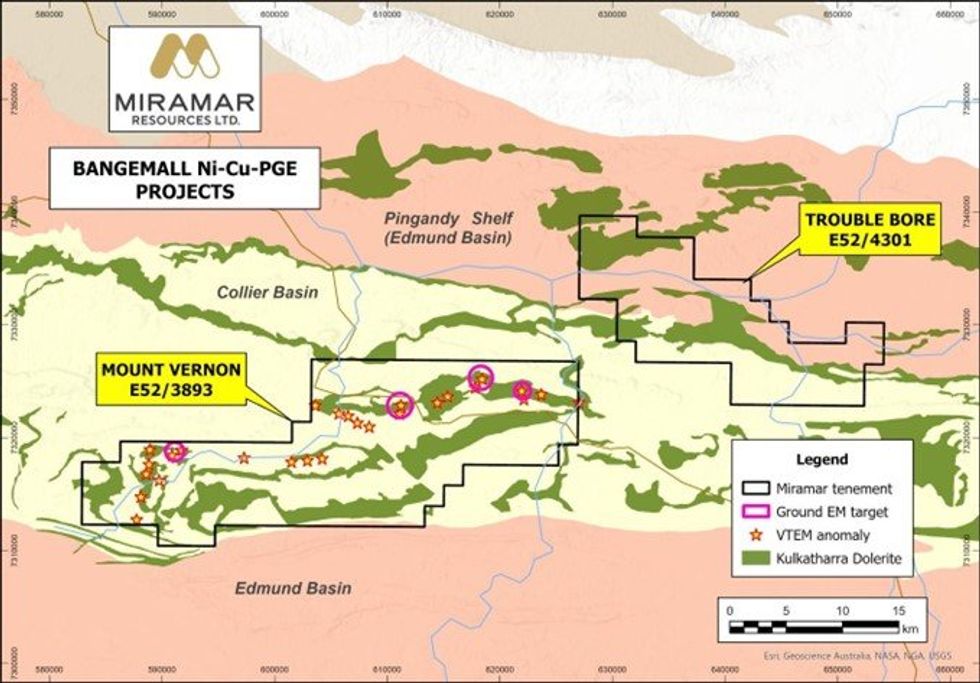 Figure 1. Exploration Licence E52/4301 (“Trouble Bore”) in relation to Mount Vernon.
Trouble Bore
Exploration Licence E52/4301 (“Trouble Bore”) is located mostly within the Collier Basin and straddles the contact with the older Edmund Basin sediments within the Pingandy Shelf (Figure 1).
Across the southern two thirds of the tenement, the local geology is dominated by Kulkatharra Dolerite sills which intrude into sediments of the Collier Basin (Figure 2). The northwestern portion of the tenement is underlain by sediments of the Edmund Basin, also intruded by a dolerite sill.
Previous exploration is limited and sporadic and focussed mainly on exploration for sediment-hosted copper, lead and zinc during the 1990’s and early 2000’s. More recent exploration since 2009 focussed on the search for channel iron deposits (CID) by Rio Tinto Exploration in the period 2012-2014.
Rio Tinto flew a SkyTEM electromagnetic survey in 2013, with N-S survey lines and a relatively broad line spacing of 1000m, and subsequently drilled three RC holes within the area now covered by E52/4301.
The RC drilling failed to intersect CID mineralisation and Rio Tinto subsequently surrendered the tenements (WAMEX reports a100526, a104395 and a106023).
The SkyTEM data highlights EM anomalies coincident with the EW-trending sub-horizontal dolerite sills as well as two N-S trending anomalies which may represent sub-vertical feeder dykes linking the sills.
Feeder dykes are an important component of the “plumbing systems” associated with Ni-Cu-PGE deposits, as shown in Figure 3.
There is minimal reported surface geochemical data across the Project.
Click here for the full ASX Release
This article includes content from Miramar Resources Limited, licensed for the purpose of publishing on Investing News Australia. This article does not constitute financial product advice. It is your responsibility to perform proper due diligence before acting upon any information provided here. Please refer to our full disclaimer here.