The Conversation (0)

Yukon Metals Corp. (CSE: YMC, FSE: E770, OTC: YMMCF the "Company" or "Yukon Metals"), is pleased to provide compelling results from gravimetric geophysical fieldwork on its road-accessible 715-hectare Star River Project located near Ross River, Yukon.
Highlights:
Rory Quinn, President & CEO stated , " We are very excited to have developed such compelling targets for a substantial drill program at Star River. The company invested in multiple tools to triangulate its absolute highest priority drill targets. The 800-meter-long gravity anomaly at F2, overlapped with a powerful electromagnetic anomaly at SR-3 shown in Figures 1-3, is supported by surface samples of up to 101 g/t gold , and multiple samples of over 1,000 g/t silver. This will be the focus of our first drilling at Star River. "
Star River is a target rich environment. In the south we have an underexplored parallel 800-meter-long anomaly, and in the north, we have multiple additional targets featuring bonanza grade silver of 10,936 g/t in addition to multiple samples of over 1000 g/t silver"
Two strong continuous anomalies were identified in the southern portion of the survey coincident with modelled zones of high conductivity from the previously reported TDEM survey at F2 and F3 showings. In the northern portion of the property, the gravity survey identified multiple anomalous high-density zones associated with most historical showings as well as a standout gravity high associated with the Key 35 showing.
The gravity survey results are noteworthy due to their association with areas of known mineralization and previously identified electromagnetic anomalies, highlighting the potential for zones of mineralization . Additionally, this survey has indicated numerous unexplored anomalies across the property, further expanding the scope for discovery and emphasizing the strong exploration potential of the area.
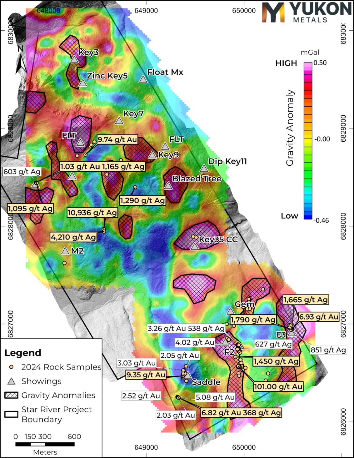
Figure 1 – A plan-view map of the Gravity Anomaly targets with significant 2024 Gold and Silver samples (results for density of 2.70 g/cm³ with a 100 m upward continued trend removed).
https://www.globenewswire.com/NewsRoom/AttachmentNg/224d06ee-ac7c-4d85-ac97-f052d27c9830
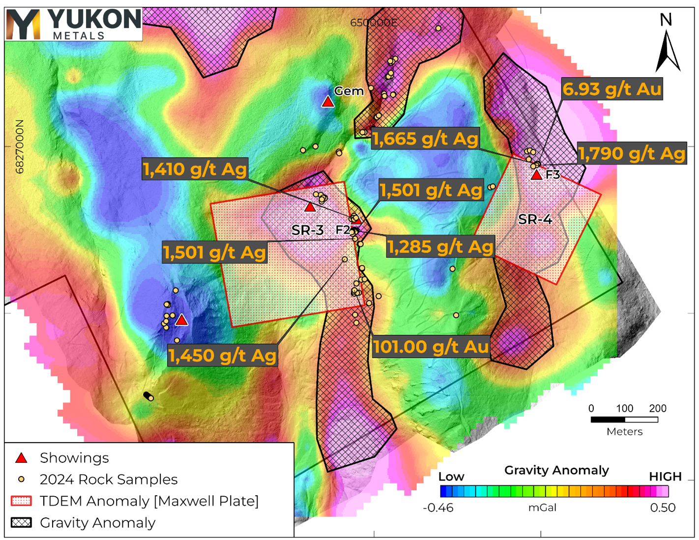
Figure 2 – A plan-view map of the Bouguer Gravity Anomaly with arrows showing overlapping TDEM and Gravity highs (results for density of 2.70 g/cm³ with a 100 m upward continued trend removed).
https://www.globenewswire.com/NewsRoom/AttachmentNg/1f728b0f-b41b-451d-adb7-2c864357da04
Further Information
In September 2024, Aurora Geosciences completed ground-based Gravity and Time Domain Electromagnetic (TDEM) surveys at the Star River property to assist in target definition and support drill hole planning. The Gravity survey was completed over most of the Star-River property. Particular attention was paid to the southern block, where TDEM survey data was previously released. An area of 3 kilometers by 4 kilometers was surveyed with a 100m line and station spacing, including additional infill at 50m x 50m spacing over the F3, F2, Lap 10, and Key 3 showing areas. The program overlaps with the previously released TDEM survey on the southern portion of the property. The results of the combined Gravity and TDEM surveys as well as 2024 prospecting and sampling program will be used to effectively generate high quality targets for future drilling campaigns.
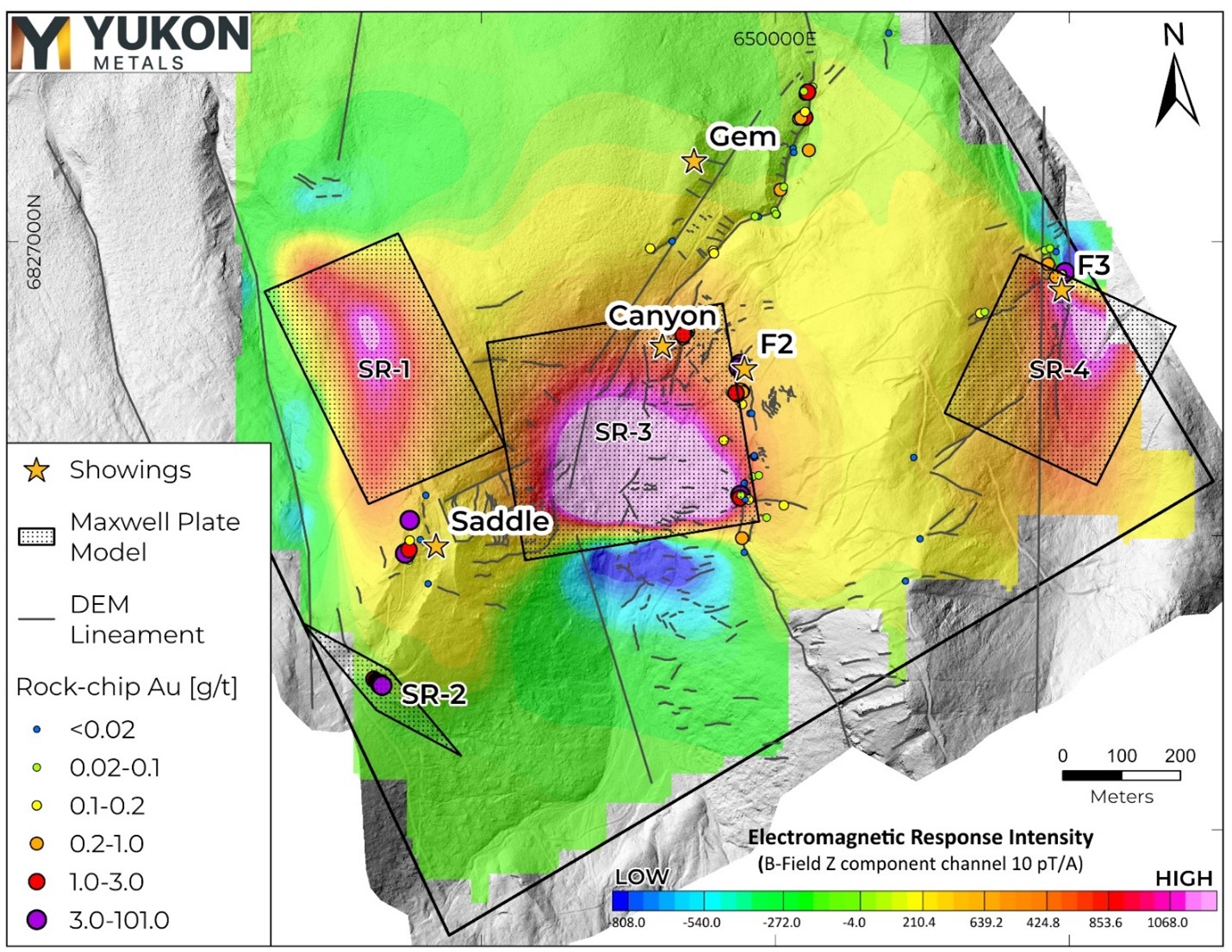
Figure 3 – Map of vertical EM response (B-field Z-component) with overlaid target plates, DEM lineaments, and Au g/t in prospecting samples.
https://www.globenewswire.com/NewsRoom/AttachmentNg/cf03dab3-656a-4395-9501-484df31fcdb2
South Block
The comparison of TDEM results with gravity data highlights coincident gravity high anomalies associated with Maxwell plates SR-3 and SR-4 (Figure 2), which are interpreted as strong indicators of exploration potential. Notably, gravity highs are often linked to areas with high concentrations of lead, silver, and gold, provided sufficient density contrast exists. The SR-4 plate demonstrates a stronger correlation, with the main gravity anomaly positioned near the top of the northerly dipping plate, while the anomaly over the SR-3 plate resolves further down-dip. These findings are further validated by the presence of known showings in these areas as well as anomalous silver and gold in rock chip samples during the 2024 field season.
Maxwell plate models from the TDEM survey SR-1 and SR-2 do not directly coincide with gravity anomalies. SR-1, in an underexplored area, sits within a gravity low response unlike the anomalies to the east and suggests the TDEM conductivity high here may be related to a conductive geologic unit rather than a higher density mineralized body.
The lack of response seen with the SR-2 plate is likely due to it's steeper dip, creating a reduced response footprint and/or because it is located at the edge of both surveys resulting in incomplete coverage. Rock-chip sampling over the SR-2 area shows elevated gold values within an oxidised manto. Additional gravity stations in this area may further resolve any density anomalies.
North Block
The northern portion of the gravity survey grid identified several anomalies associated with historical polymetallic vein showings including at FLT, Key 9, Lap 10, Key 3, and Blazed Tree (Figure 1). One notable anomaly in a yet unnamed area is proximal to the rock-chip float sample identified in the 2024 prospecting program of 10,936 g/t silver. In addition, the Key 35 showing gravity anomaly is of particular interest as it appears as a well-isolated, strong gravity high anomaly within an otherwise lower amplitude area. Rock-chip sampling in this area showed elevated gold values in a massive pyrite vein.
About the Star River Project
Yukon Metals owns 100% of the Star River base and precious metals project accessible by all-season road from the Robert Campbell Highway and adjacent to the former Ketza Mine haul road. The project is host to multiple showings of polymetallic carbonate replacement mineralization and quartz-sulphide veins first discovered in the 1950s. Remnants of underground and surface workings using historical exploration techniques are visible around much of the property and tied together with previously established access roads and trails branching from the Ketza Mine Road.
Methodology
Gravity Survey
A gravity survey measures variations in the Earth's gravitational field to identify subsurface density differences. It is used to detect dense mineralized bodies, such as those containing lead, silver, or gold, by highlighting gravity anomalies associated with these materials. Instrumentation used in the Star-River survey consisted of two Scintrex gravimeters and two Leica RTK GPS receivers. Figure 4 shows the placement and coverage of the gravity stations on the Star River property covering an area of 3 km by 4 km. A 100m x 100m line and station spacing was used over most of the survey area with 50m x 50m spacing around the Lap 10, F2, F3, and Key 3 showing areas. Part of the northern survey area over cliff terrain was not accessible during the program and several stations were not included.
Sampling
Rock samples were sent to ALS Minerals for analysis with sample preparation in Whitehorse, Yukon and analysis in North Vancouver, British Columbia.
Samples were prepared by crush to 70 % passing 2mm, 250g split pulverised better than 85% passing 75 microns (Prep-31A). Pulp samples were analysed for 34 elements by four acid digestion and ICP-AES (ME-ICP61). All samples were analyzed for gold by fire assay and AAS with a 50g nominal sample weight (Au-AA24). Samples over 10 g/t Au were assayed with 50g sample fire assay with gravimetric finish (Au-GRA22). Samples over 1500 g/t Ag were assayed by 50g sample fire assay with gravimetric finish (Ag-GRA21). Samples over 10,000 g/t Ag were analysed with Ag-CON01.
Rock samples taken while prospecting referenced in this release are selective in nature and collected to determine the presence or absence of mineralization and may not be representative of the mineralization hosted on the project.
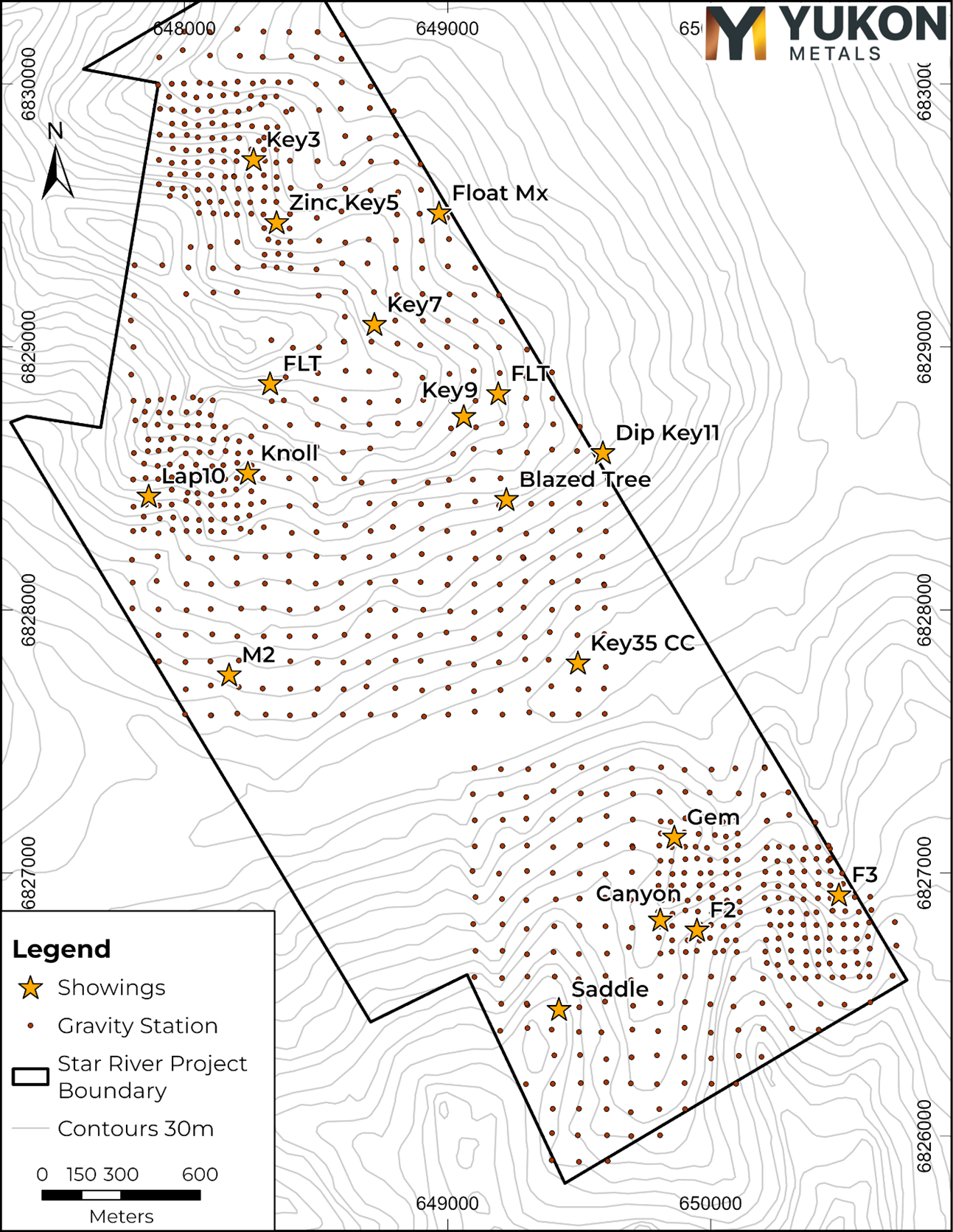
Figure 4 – A plan-view map showing the ground gravity survey area and the measured station locations.
https://www.globenewswire.com/NewsRoom/AttachmentNg/c064c933-2cfb-4d1a-86d6-644d9b6b8ddc
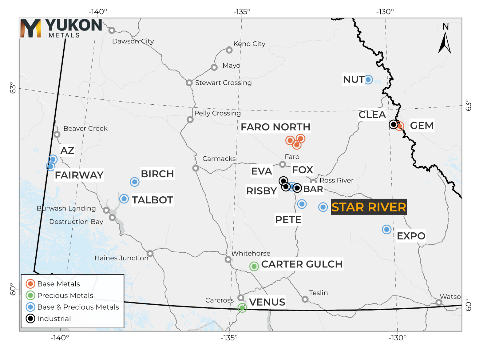
Figure 5 – Star River Project Location Map
https://www.globenewswire.com/NewsRoom/AttachmentNg/7921e252-7bf0-45bb-b71c-7e9f5a35ec6b
Qualified Person
The technical content of this news release has been reviewed and approved by Helena Kuikka, P.Geo., VP Exploration for Yukon Metals and a Qualified Person (as defined by National Instrument 43-101).
About Yukon Metals Corp.
Yukon Metals is well financed and represents a property portfolio built on over 30 years of prospecting by the Berdahl family, the prospecting team behind Snowline Gold's portfolio of primary gold assets . The Yukon Metals portfolio consists of 17 properties, including copper-gold and silver-lead-zinc assets as well as critical metals, with a substantial gold and silver component across the portfolio. The Company is led by an experienced Board of Directors and Management Team across technical and finance disciplines.
Yukon Metals is focused on fostering sustainable growth and prosperity within Yukon's local communities, while simultaneously enhancing stakeholder value. Our strategy centers around inclusivity and shared prosperity, offering both community members and investors the chance to contribute to, and benefit from, our ventures.
The Yukon
The Yukon ranks 10ᵗʰ most prospective for mineral potential across global jurisdictions according to the Fraser Institute's 2023 Survey of Mining Companies, and is host to a highly experienced and conscientious local workforce, fostered by a long culture of exploration coupled with deep respect for the land. Recent major discoveries with local roots such as Snowline Gold's Rogue Project – Valley Discovery, demonstrate the Yukon's potential to generate fresh district-scale mining opportunities.
Yukon Metals CORP.
"Rory Quinn"
Rory Quinn, President & CEO
Email: roryquinn@yukonmetals.com
CAUTIONARY NOTE REGARDING FORWARD-LOOKING INFORMATION
This news release contains certain forward-looking information, including information about the metal association and geology of the prospect area at Star River, strong electromagnetic responses coincident with gold and silver sampling pointing to gold and silver deposits, the accuracy of the completed plate modelling and geophysical surveys, the potential for economic grades of silver and gold, Yukon's potential to generate fresh district-scale mining opportunities, and the Company's future plans and intentions. Wherever possible, words such as "may", "will", "should", "could", "expect", "plan", "intend", "anticipate", "believe", "estimate", "predict" or "potential" or the negative or other variations of these words, or similar words or phrases, have been used to identify the forward-looking information. These statements reflect management's current beliefs and are based on information currently available to management as at the date hereof.
Forward-looking information involves significant risks, uncertainties and assumptions. Many factors could cause actual results, performance or achievements to differ materially from those discussed or implied in the forward-looking information. Such factors include, among other things: risks and uncertainties relating to Star River not being a prospective gold-rich or silver-rich geological system; rock samples analysed not being representative of overall mineralization; the required assumptions of completed plate modelling results; not having significant scale and a lack of economic grade minerals; the Yukon not having the potential to generate fresh district-scale mining opportunities; and other risks and uncertainties. See the section entitled "Risk Factors" in the Company's listing statement dated May 30, 2024, available under the Company's profile on SEDAR+ at www.sedarplus.ca for additional risk factors. These factors should be considered carefully, and readers should not place undue reliance on the forward-looking information. Although the forward-looking information contained in this news release is based upon what management believes to be reasonable assumptions, the Company cannot assure readers that actual results will be consistent with the forward-looking information. The forward-looking information is made as of the date of this news release, and the Company assumes no obligation to update or revise the information to reflect new events or circumstances, except as required by law.
Tempelman-Kluit, D.J., 2012. Geology of the Quiet Lake and Finlayson Lake map areas, south-central Yukon – An early interpretation of bedrock stratigraphy and structure; Geological Survey of Canada, Open File 5487. Doi: 10.4095/291931
![]()
News Provided by GlobeNewswire via QuoteMedia