CSE:CRVC

Cross River Confirms High Grade Gold at the Maskootch Project; Assays Select Grab Samples up to 32 g/t Au


Cross River Ventures Corp. (CSE: CRVC) (OTCQB: CSRVF) (FSE: C6R) (the "Company") is pleased to update shareholders on the results of recently completed exploration work at its 1,480-ha Maskootch project, situated along the southeastern margin of Archean Uchi Greenstone Belt, NW Ontario, Canada.


A team of four personnel contracted by Bayside Geoscience of Thunder Bay, Ontario, recently completed an 8-day field program at Maskootch. The team conducted prospecting and mapping around areas of historic gold ("Au") mineralization at the Wenesaga Road prospect on the western side of the project and the Maskootch copper showing on the eastern side of the project (Figure 1).


Wenesaga Road Showing


The team collected three grab samples from semi-massive pyrite-chalcopyrite mineralization at the historic Wenesaga Road showing. Two locally derived angular boulders, samples D579821 and D579823, returned values of 32.0 grams-per-tonne ("g/t") Au with 0.79% Copper and 22.5g/t Au respectively.


Sample D579822 from the mineralized outcrop returned 8.29 g/t Au and 0.31% copper. Mineralization at the Wenesaga Road showing is confined to a 30 cm wide zone of sulfide mineralization that appears to be strongly lineated, plunging 240 degrees at an inclination of 62 degrees.


There does not appear to be any significant strike extent to the showing, though it may be largely removed in the road cut. Follow up work on this zone will focus on the down-plunge extent of the mineralization.


Maskootch Copper Showing


Mapping and sampling at the Maskootch copper showing along the eastern margin of the property returned 3 samples with elevated copper values. The team collected the samples from a series of historic trenches along a contact between felsic-intermediate tuff breccias and tuffs and mafic tuff breccia to iron formation. Samples D579784, D579791, and D579796 returned 0.30%, 0.09% and 0.06% copper, respectively.


Gossans host the mineralization along this contact zone. They reflect the presence of iron oxides and sulfides in the host felsic-intermediate volcaniclastics. The mafic volcanic rocks nearby contain garnet porphyroblasts and magnetite-pyrite mineralization. These minerals indicate extensive hydrothermal alteration.


The team mapped this E-W trending horizon nearly continuously over 3 km south of Maskooch Lake. An intermediate volcanic breccia sequence, just south of the contact, shows strong bleaching and chlorite alteration cutting bleached host rocks.


A cursory model of this area indicates that the bleached and chloritized intermediate volcanic rocks to the south of the sulfide bearing horizon may be the footwall alteration system to potential VMS style mineralization.


On the west side of Maskooch Lake a ridge of intermediate volcanic tuff, sample D579811, returned 0.15% Copper. This area in general has minimal outcrop exposure due to the presence of sandy till in the area. Mineralization and mineralogy here is like that on the east side of Maskooch Lake, suggesting continuity of this strata 3km to the NW


In addition to confirming high grades in the central part of the property adjacent to Wenesaga Road, the team identified a new gold showing in the northeastern portion of the property called the Skootch Showing.


The team collected a total of 87 grab/outcrop/subcrop samples during the program. Four samples returned values of greater than 1 g/t Au and four samples returned copper grades above 0.10%. The Table below summarizes the selected results:


Sample IDSample MethodGold (g/t)Silver (g/t)Copper (%)
D579821Float32.01090.79%
D579823Float22.512.10.07%
D579822Outcrop8.2924.10.31%
D579837Outcrop1.131.200.0%
D579784Outcrop0.042.600.30%
D579811Outcrop0.060.900.14%
D579791Outcrop0.021.820.09%
D579796Subcrop0.031.630.06%


The following maps show the locations of the selected samples in context of historic data:


Cannot view this image? Visit: https://orders.newsfilecorp.com/files/7276/101989_158f9539a4c799df_002.jpg

Figure 1: Gold Sample Locations, Maskootch project, NW Ontario, Canada


To view an enhanced version of Figure 1, please visit:
https://orders.newsfilecorp.com/files/7276/101989_158f9539a4c799df_002full.jpg


Cannot view this image? Visit: https://orders.newsfilecorp.com/files/7276/101989_158f9539a4c799df_003.jpg

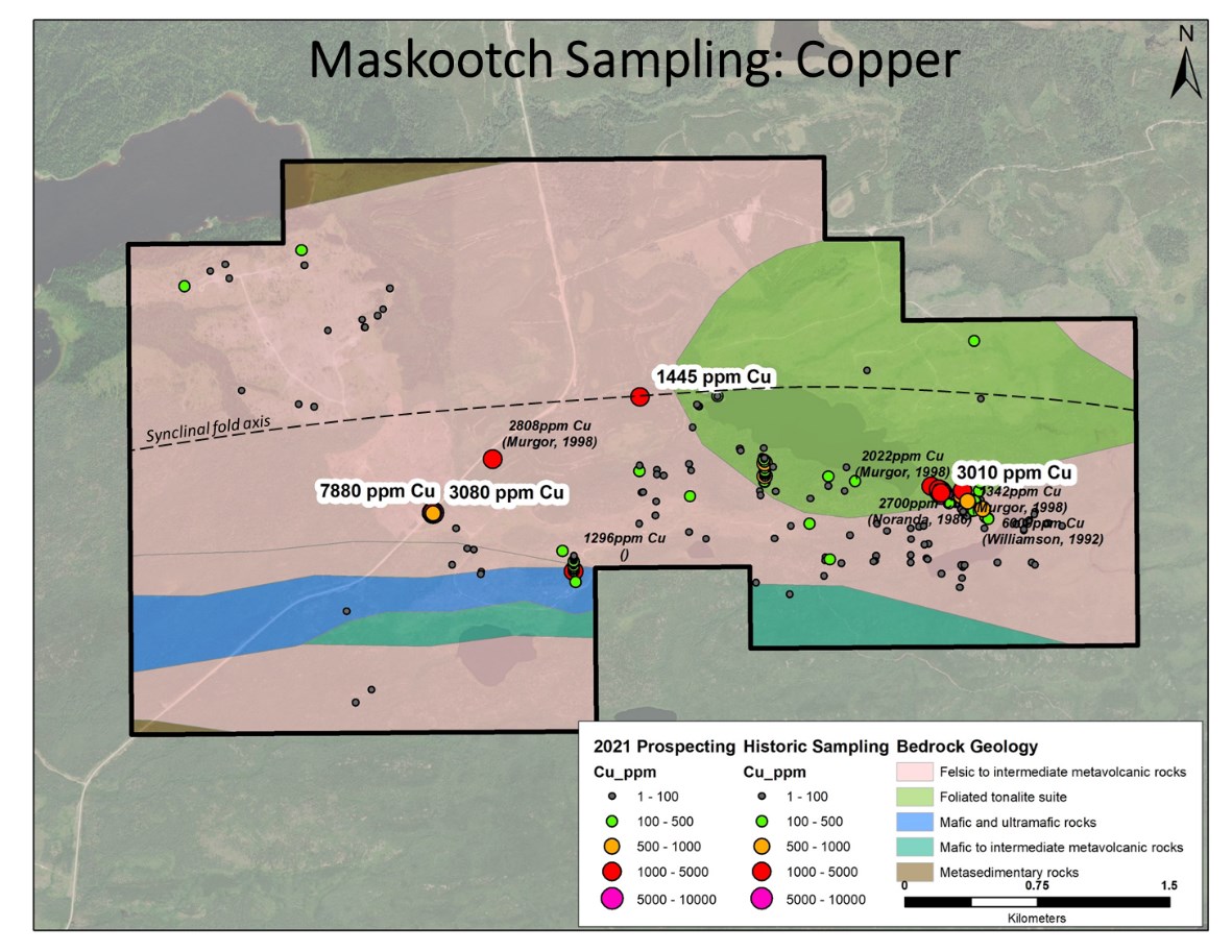
Figure 2: Copper Sample Locations, Maskootch project, NW Ontario, Canada


To view an enhanced version of Figure 2, please visit:
https://orders.newsfilecorp.com/files/7276/101989_158f9539a4c799df_003full.jpg


Work completed during the 8-day prospecting program verified the presence of high-grade gold and elevated copper values within sulfide bearing volcaniclastic rocks. Mapping of the property suggests the presence of a hydrothermal alteration system with the potential to host gold rich VMS style mineralization down-plunge from known mineralization.


Sandy till obscures bedrock in the area north and west of Maskooch Lake. However, the anomalous copper mineralization encountered on the west side of Maskooch Lake warrant geophysics in the future.


Property Highlights:


The Maskootch project is a 1,480-hectare claim block on the southeastern margin of the Uchi Greenstone Belt. A series of ultramafic to felsic volcanic rocks underly the property. The volcanics contain narrow banded iron formation intruded by foliated tonalite.


Previous work was focused on Volcanogenic massive sulphide mineralization based on mineralization textures associated with gold and copper showings including Maskootch (copper) and Wenesaga Road (gold). (Figures 1 and 2).


The Maskootch copper prospect sits near the contact between tonalite intrusions and intermediate to felsic metavolcanics. Trench samples reported in 1984 include 0.43% Copper over 1m. Grab samples reported in 1986 returned anomalous but low-grade gold (MDI 52K16NW 000141). In 2009, diamond drilling of airborne electromagnetic conductors returned weakly anomalous copper and gold values from sulphide-bearing iron formation.


The Wenesaga Road gold prospect is situated in felsic-intermediate metavolcanic rocks along the western side of the Maskootch property (Figure 1). There are anecdotal reports of high-grade surface gold (several oz Au samples referenced in the 1991 MDI**. There are no assays available from trench sampling in the late 1980's. There is a single drill hole reported in the area from 1990 that yielded weakly anomalous gold values.


The Maskootch property is considered underexplored despite its favourable host rock geology, extensive alteration footprints which indicate the land position has potential for economic orogenic gold and/or VMS style mineralization. High-priority exploration targets include mafic-felsic rock contacts, margins of mafic-ultramafic intrusions, and iron formation host rocks; all of which have yielded significant deposits in the region.


The Maskootch property is an overlooked exploration asset in the Uchi Greenstone Belt. The recent option agreement between Kenorland Minerals and Barrick Gold Corp. on ground surrounding Maskootch demonstrates the renewed interest in the region. Barrick Gold agreed to spend $6 million over six years to earn 70% of the South Uchi project.


For more detailed area maps of Maskootch and the Cross River Ventures project portfolio, please visit www.crossriverventures.com.


Analytical Procedure


All 2021 samples pertaining to this release were sent to ALS Geochemistry Laboratories in Thunder Bay, Ontario, for analysis. Samples were prepared using PREP-31 standard rock/core package and analyzed for gold using standard Fire Assay and ICP-AES (ALS Code: Au-ICP21). Samples returning over 10.0 g/t Au were then analyzed using Fire Assay - Gravimetric finish methods (ALS Code: Au-GRA21).


* Note: Grab samples are selective by nature and may not be representative of the average grade or style of mineralization but will be used to help guide additional exploration on the properties.


The technical content disclosed in this press release was reviewed and approved by Mr. Steven Flank, P.Geo, MSc., a Qualified Person as defined under National Instrument 43-101. Historical assay results contained in this press release were not verified by the Company, however, the historical reports referenced were authored by experienced geoscientists and copies of laboratory assay sheets were commonly inserted in the reports.


References and Disclosure


1 www.geologyontario.mndm.gov.on.ca/mndmfiles/mdi/data/records/MDI52K16NW00006.htm 


**The Mineral Deposit Inventory (MDI) provides an overview of mineral occurrences in the province of Ontario and can be found here: https://www.geologyontario.mndm.gov.on.ca/ogsearth.html#mineral-deposit-inventory


About the Company


Cross River is a gold exploration company focused on the development of top tier exploration properties located in emerging Greenstone Districts of NW Ontario, Canada. The Company controls a 28,0090-ha, multiple project portfolio with highly prospective ground in and among prolific, gold bearing greenstone belts. Cross River's common shares trade in Canada under the symbol "CRVC" on the CSE, and in the US under the symbol "CSRVF" on the OTCQB. Please visit www.crossriverventures.com for more information.


On behalf of the Board of Directors of


Cross River Ventures CORP.


Alex Klenman
CEO
604-227-6610
aklenman@crossriverventures.com
www.crossriverventures.com


Neither the Canadian Securities Exchange nor its Regulation Services Provider (as that term is defined in the policies of the Canadian Securities Exchange) accepts responsibility for the adequacy or accuracy of this release.


This news release may contain forward-looking statements. These statements are based on current expectations and assumptions that are subject to risks and uncertainties. Actual results could differ materially because of factors discussed in the management discussion and analysis section of our interim and most recent annual financial statement or other reports and filings with the Canadian Securities Exchange and applicable Canadian securities regulations. We do not assume any obligation to update any forward-looking statements, except as required by applicable laws.


To view the source version of this press release, please visit https://www.newsfilecorp.com/release/101989


News Provided by Newsfile via QuoteMedia

The Conversation (0)
John Feneck, gold bars.

John Feneck: Gold, Silver, Platinum, Copper — 8 Stocks to Play These Metals

John Feneck, portfolio manager and consultant at Feneck Consulting, outlines his latest thoughts on the gold, silver, platinum and copper markets.

With prices on the rise, he encouraged investors to get involved if they aren't already.

Keep reading...Show less
The super pit, or Fimiston open pit.

Hidden Gem: How Intrusion-related Gold Deposits Could Fuel Next-generation Discoveries

With the gold price continuing to hover near all-time highs and major producers scouring the globe for new large-scale deposits, one type of gold system is emerging as a potential game changer.

Intrusion-related gold systems (IRGS) have already yielded multimillion-ounce mines, like Kinross Gold's (TSX:K,NYSE:KGC) Fort Knox in Alaska, and sparked billion-dollar acquisition bids, such as Northern Star Resources (ASX:NST) offer for De Grey Mining in Australia. Even so, these deposits remains largely under the radar for most investors, and their full investment potential is only beginning to be understood.

Traditional high-grade vein systems often require deep, high-cost underground mining. IRGS deposits, however, form broad, consistent zones of mineralization that lend themselves to large-scale, open-pit development. These geological systems are particularly attractive in today’s market as they offer scale, longevity and a clear path to resource growth, which are critical at a time when new gold discoveries are becoming increasingly rare.

Keep reading...Show less
Blackrock Silver Commences Eastern Expansion Drill Program Targeting 1.2km Trend at Tonopah West

Blackrock Silver Commences Eastern Expansion Drill Program Targeting 1.2km Trend at Tonopah West


Scout Drilling Discovered the Extension of the High-grade Merten Vein Creating an Opportunity to Expand the Dpb Resource up to 1,200 Metres to the East


SCOUT PROGRAM HIGHLIGHTS:

 
  • Assay results from the Company's reverse circulation Scout Drill Program (see March 31, 2025 news) returned significant gold & silver values in 7 drillholes that successfully expanded the footprint of mineralization up to 1,200 metres from the east of the existing DPB resource toward the historic Ohio mine;

  •  
  • These intercepts cover a new zone of silver and gold interpreted to be the outer ring structure of the Fraction caldera, and are not included in the 2024 resource;

  •  
  • A fully funded 15 drillhole program totalling up to 5,000 metres is underway; and

  •  
  • Results from this program will be incorporated into an updated Mineral Resource Estimate in Q1, 2026.

  •  

Vancouver, British Columbia--(Newsfile Corp. - July 21, 2025) - Blackrock Silver Corp. (TSXV: BRC,OTC:BKRRF) (OTCQX: BKRRF) (FSE: AHZ0) ("Blackrock" or the "Company") announces commencement of a fully-funded expansion drill program ("Expansion Program") to follow up on the successful Scout Drilling campaign that expanded the DPB South zone 1,200 metres in an easterly direction on its 100% owned Tonopah West project located in Nye and Esmeralda Counties, Nevada, United States.


The Expansion Program will utilize one Reverse Circulation (RC) drill overseen by Legacy Drilling and two core drill rigs operated by Alloy Drilling to complete 2,450 metres (8,000 ft) of RC precollars and 2,550 metres (8,400 ft) of core tails across 15 drillholes targeting the Eastern Expansion zone between the DPB resource area and the eastern extent of the project. Drilling is anticipated to be completed in October with assay results expected through year end.


Andrew Pollard, Blackrock's President and CEO, stated, "With drills now turning on this fully financed program, we're stepping out across a 1.2-kilometre corridor with strong potential to significantly expand our mineral inventory at Tonopah West. Scout drilling confirmed the eastern extension of the high-grade Merten vein well beyond the current resource boundary, returning standout grades including 2,063 grams per tonne (g/t) silver equivalent (AgEq) (1,198 g/t silver (Ag) and 9.6 g/t gold (Au)) over 1.52 metres, and 952 g/t AgEq (10 g/t Ag and 10.5 g/t Au) over 4.57 metres. This newly defined zone, situated along the outer ring structure of the Fraction caldera, lies entirely outside our 2024 resource and presents an opportunity to quickly and meaningfully grow the scale of the project. Results from this program are expected to underpin a resource update in Q1 2026. The Company remains on track to deliver a separate resource update in Q3 2025 that will incorporate all results from the recently completed M&I conversion program."


As announced on March 31, 2025, the Company discovered the 1,200 metre eastern extension zone representing the continuation of the outer-ring structure or Fraction caldera margin from DPB South to the historic Ohio mine. The Scout Drilling showed the Merten vein extends eastward and is arched and dips southward. This orientation suggests multiple ring structures associated with the Fraction caldera running across Tonopah West. An inner structure hosting the Victor and DPB North (Denver and Paymaster) resources, and an outer, more southern, ring structure hosting DPB South (Merten and Bermuda) and the NW Stepout resources (See Figure 1). The arching geometry of the Merten vein is similar to that described from the historic Ohio vein which was 15 metres thick when mined in the early 1900s1. Given the geometry and location, the Merten is potentially the extension of the Ohio vein. Table 1 summarizes the Scout Drilling assay results above 150 g/t AgEq.


Table 1: Scout Drilling Program results above 150 g/t AgEq


Drillhole IDHole 
Type
AreaFrom 
(m)
To
 (m)
Drill
 Interval
 (m)
Ag g/tAu g/tAgEq g/t
TW25-125RCDPB East220.98222.501.5276.412.010257.3
TW25-127RCDPB East390.15391.671.528.001.750165.5
TW25-130RCDPB East188.98190.501.52290.003.300587.0
TW25-132RCDPB East245.36246.891.5278.581.180184.8
TW25-133RCDPB East280.42283.473.05129.081.575270.8
TW25-133RCDPB East309.37313.954.5710.6510.456951.8
Including309.37310.901.5215.7321.4671,948.0
TW25-128RCOhio292.61294.131.521,198.009.6102,063.0
TW25-128RCOhio297.18298.711.52219.001.720373.8
TW25-131RCOhio269.75271.271.5289.102.630325.8
AgEq gpt=(Au gpt*90)+Ag gpt; True thickness unknown at this time; Cut-off grade is 150 gpt AgEq;
RC = Reverse Circulation Drilling


TW25-133 returned significant silver and gold with values starting at 309-metres grading 10.46 g/t gold and 10.6 g/t silver over 4.57 metres (952 g/t AgEq), and show mineralization extends along the Merten vein for 540 meters to the east-southeast of the main DPB South resource. With the inclusion of TW25-128 which returned 9.6 g/t gold and 1198 g/t silver over 1.5-metres (2,063 g/t AgEq), the zone could be up to 1,200-metres in length.


The mineralized zone traced by these assay results is new and not included in the 2024 resource. These results could have a substantive impact on the future resource estimate.


Cannot view this image? Visit: https://images.newsfilecorp.com/files/676/259346_2ae57e3a248179b3_001.jpg


Figure 1: Tonopah West expansion potential


To view an enhanced version of this graphic, please visit:
https://images.newsfilecorp.com/files/676/259346_2ae57e3a248179b3_001full.jpg


Cannot view this image? Visit: https://images.newsfilecorp.com/files/676/259346_2ae57e3a248179b3_002.jpg


Figure 2: Drillhole location map with cross section line at location 478540E


To view an enhanced version of this graphic, please visit:
https://images.newsfilecorp.com/files/676/259346_2ae57e3a248179b3_002full.jpg


Cannot view this image? Visit: https://images.newsfilecorp.com/files/676/259346_2ae57e3a248179b3_003.jpg


Figure 3: Geologic cross section along 478540E


To view an enhanced version of this graphic, please visit:
https://images.newsfilecorp.com/files/676/259346_2ae57e3a248179b3_003full.jpg


Quality Assurance/ Quality Control


All sampling is conducted under the supervision of the Company's project geologists, and a strict chain of custody from the project to the sample preparation facility is implemented and monitored. The RC samples are hauled from the project site to a secure and fenced facility in Tonopah, Nevada, where they are loaded on to American Assay Laboratory's (AAL) flat-bed truck and delivered to AAL's facility in Sparks, Nevada. A sample submittal sheet is delivered to AAL personnel who organize and process the sample intervals pursuant to the Company's instructions.


The RC samples are lined out at the lab and logged into AAL's system. The samples are dried, crushed to 85% passing 10 mesh (2mm) and a 250-gram sub-sample split is collected and pulverized to 200 mesh (74 micron) in a ring and puck pulverizer. Then the pulverized material is digested and analyzed for gold using fire assay fusion and an Induced Coupled Plasma (ICP) finish on a 30-gram assay split (FA-PB30-ICP). Silver is determined using five-acid digestion and ICP analysis (ICP-5AM48). Over limits for gold and silver are determined using a gravimetric finish (GRAVAU30 and GRAVAG30). Data verification of the assay and analytical results are completed to ensure accurate and verifiable results. Blackrock personnel insert a blind prep blank, lab blank or a certified reference material approximately every 15th to 20th sample.


Qualified Persons


Blackrock's exploration activities at Tonopah West are conducted and supervised by Mr. William Howald, Executive Chairman of Blackrock. Mr. William Howald, AIPG Certified Professional Geologist #11041, is a Qualified Person as defined under National Instrument 43-101 - Standards of Disclosure for Mineral Projects. He has reviewed and approved the contents of this news release.


About Blackrock Silver Corp.


Backed by gold and silver ounces in the ground, Blackrock is a junior precious metal focused exploration and development company driven to add shareholder value. Anchored by a seasoned Board of Directors, the Company is focused on its 100% controlled Nevada portfolio of properties consisting of low-sulphidation, epithermal gold and silver mineralization located along the established Northern Nevada Rift in north-central Nevada and the Walker Lane trend in western Nevada.


Additional information on Blackrock Silver Corp. can be found on its website at www.blackrocksilver.com and by reviewing its profile on SEDAR at www.sedarplus.ca.


Cautionary Note Regarding Forward-Looking Statements and Information


This news release contains "forward-looking statements" and "forward-looking information" (collectively, "forward-looking statements") within the meaning of Canadian and United States securities legislation, including the United States Private Securities Litigation Reform Act of 1995. All statements, other than statements of historical fact, are forward-looking statements. Forward-looking statements in this news release relate to, among other things: the Company's strategic plans; the timing of and successful completion of the Company's Expansion Program at Tonopah West and the anticipated objectives and results therefrom; timing and estimates of mineral resource quantities and qualities; timing of updated resource estimates; estimates of mineralization from drilling; geological information projected from sampling results; and the potential quantities and grades of the target zones.


These forward-looking statements reflect the Company's current views with respect to future events and are necessarily based upon a number of assumptions that, while considered reasonable by the Company, are inherently subject to significant operational, business, economic and regulatory uncertainties and contingencies. These assumptions include, among other things: conditions in general economic and financial markets; accuracy of assay results; geological interpretations from drilling results, timing and amount of capital expenditures; performance of available laboratory and other related services; future operating costs; the historical basis for current estimates of potential quantities and grades of target zones; the availability of skilled labour and no labour related disruptions at any of the Company's operations; no unplanned delays or interruptions in scheduled activities; all necessary permits, licenses and regulatory approvals for operations are received in a timely manner; the ability to secure and maintain title and ownership to properties and the surface rights necessary for operations; and the Company's ability to comply with environmental, health and safety laws. The foregoing list of assumptions is not exhaustive.


The Company cautions the reader that forward-looking statements involve known and unknown risks, uncertainties and other factors that may cause actual results and developments to differ materially from those expressed or implied by such forward-looking statements contained in this news release and the Company has made assumptions and estimates based on or related to many of these factors. Such factors include, without limitation: the timing and content of work programs; results of exploration activities and development of mineral properties; the interpretation and uncertainties of drilling results and other geological data; receipt, maintenance and security of permits and mineral property titles; environmental and other regulatory risks; project costs overruns or unanticipated costs and expenses; availability of funds; failure to delineate potential quantities and grades of the target zones based on historical data; general market and industry conditions; and those factors identified under the caption "Risks Factors" in the Company's most recent Annual Information Form.


Forward-looking statements are based on the expectations and opinions of the Company's management on the date the statements are made. The assumptions used in the preparation of such statements, although considered reasonable at the time of preparation, may prove to be imprecise and, as such, readers are cautioned not to place undue reliance on these forward-looking statements, which speak only as of the date the statements were made. The Company undertakes no obligation to update or revise any forward-looking statements included in this news release if these beliefs, estimates and opinions or other circumstances should change, except as otherwise required by applicable law.


Neither the TSX Venture Exchange nor its Regulation Services Provider (as that term is defined in the policies of the TSX Venture Exchange) accepts responsibility for the adequacy or accuracy of this release.


For Further Information, Contact:


Andrew Pollard
President and Chief Executive Officer
(604) 817-6044
info@blackrocksilver.com 


News Provided by Newsfile via QuoteMedia

Keep reading...Show less
LaFleur Minerals (CSE:LFLR)

LaFleur Minerals

Keep reading...Show less

Latest Press Releases

Related News

×