The Conversation (0)
Yukon Metals Corp. (CSE: YMC, FSE: E770, OTC: YMMCF the "Company" or "Yukon Metals"), is pleased to provide an update from the 2024 reconnaissance fieldwork on its 715-hectare Star River Project, located 50 kilometres ("km") due south of Ross River, Yukon, with all-season road access.
In September 2024, Aurora Geosciences of Yellowknife, NWT completed ground-based Gravity and Time Domain Electromagnetic (TDEM) surveys at the Star River property to assist in target definition and support drill hole planning. The TDEM survey was completed over the southern portion of the property over a carbonate rock package, results of which are presented here. Four prominent conductive zones were identified in the TDEM survey and Maxwell plate modelling. Three zones are coincident with historic mineral showings and 2024 high-grade rock chip samples at Saddle, Canyon/F2, and F3. One zone north of the Saddle showing is in an underexplored area. In addition, a LiDAR DEM (Digital Elevation Model) lineament analysis revealing bedrock structures (Figure 2) was conducted by Yukon Metals and is presented with the TDEM and rock geochemical data in Figure 1 .
Rory Quinn, President & CEO stated , " We are excited to report multiple compelling targets with strong electromagnetic responses coincident with gold and silver sampling featuring up to 101 grams per tonne gold. These targets are not only strong anomalies, they are large anomalies, and will help focus our exploration efforts to maximize our chances of adding substantial value to the project through drilling."
A total of 20.6-line kilometers was completed with 100m line spacing, including additional infill lines at 50m spacing over the F3 showing area. The program involved three large, fixed ground loops at 500m x 500m size covering the Saddle, F2, Canyon, and F3 showings. The Maxwell plates are interpreted simplified representations of subsurface conductive bodies based on EM responses, which may correspond to zones of metal-rich mineralization. The plate modeling assumes flat, tabular shapes that may not fully capture complex geology, and results can be sensitive to input parameters. Ongoing interpretive work is aimed at refining these models by integrating additional geological parameters to improve accuracy and provide detail in order to understand the complexity of subsurface structures.
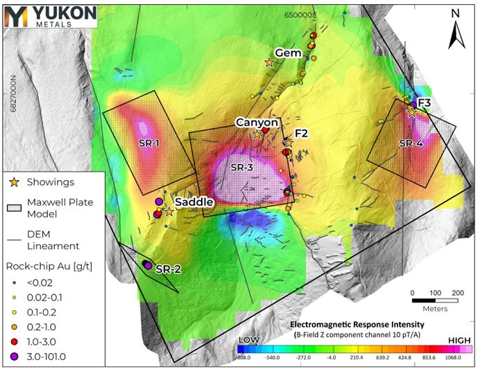
Figure 1- Map of vertical EM response (B-field Z-component) with overlaid target plates, DEM lineaments, and Au g/t in prospecting samples.
Table 1- Maxwell Plate Model Parameters
| Name | UTM X (m) | UTM Y (m) | UTM Z (m) | Dip (°) | Dip Direction (°) | Plunge (°) | Length (m) | Depth Extent (m) |
| SR-1 | 649244 | 6826961 | 1319.9 | 27.8 | 347.6 | 13.1 | 250 | 450 |
| SR-2 | 649404 | 6826196 | 1594.1 | 79.2 | 220.7 | -40.0 | 250 | 250 |
| SR-3 | 649771 | 6826490 | 1449.5 | 19.4 | 346.6 | -4.2 | 400 | 400 |
| SR-4 | 650549 | 6826918 | 1383.3 | 14.5 | 300.4 | -85.1 | 300 | 300 |
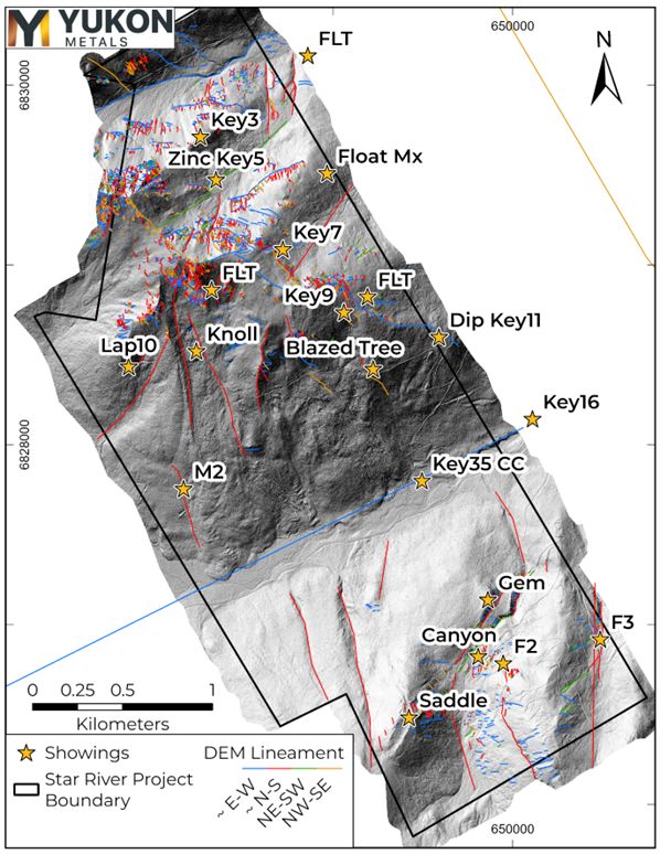
Figure 2- LiDAR Digital Elevation Model lineament analysis.
A detailed DEM lineament analysis was conducted using high-resolution drone LiDAR data, focusing primarily on areas with outcrop exposures to identify structural features that could influence mineralization pathways. This analysis involved digitally mapping linear features and highlighting interesting areas for future ground truthing. Anomalous silver and gold in prospecting samples taken near the F2 and F3 showings follow prominent N-S lineaments. Further analysis is ongoing to integrate these lineaments with geochemical, geophysical and geologic data, aiding in the refinement of exploration targets.
About the Star River Project
Yukon Metals owns 100% of the Star River base and precious metals project accessible by all-season road from the Robert Campbell Highway and adjacent to the former Ketza Mine haul road. The project is host to multiple showings of polymetallic carbonate replacement mineralization and quartz-sulphide veins first discovered in the 1950s. Remnants of underground and surface workings using historical exploration techniques are visible around much of the property and tied together with previously established access roads and trails branching from the Ketza Mine road.
Methodology
Lineament Analysis
Hillshade images at varying illumination and altitude angles and varying vertical exaggeration factors were produced from detailed drone LiDAR data and used to digitally draw lineaments. In this analysis, DEM lineaments were drawn at three scales: 1: 100 000, 1: 50 000 and 1: 25 000 on areas with prominent features or outcrop exposures.
TDEM
Aurora Geophysics conducted the ground TDEM survey using the ARMIT b-Field and dB/dt system, developed by Abitibi Geophysics. The grid was surveyed using 25 m stations along each 100m spaced line. Three loops of 500m x 500m were used to survey the grid and receiver stations were read off the end of each loop and in-loop to complete each survey line. This approach was proposed as the most effective balance of survey resolution, efficiency, and EM coupling with the targeted manto-chimney style mineralization. TDEM data was delivered in AMIRA format (B-field) and plates were modelled in Maxwell software by ElectroMagnetic Imaging Technology.
Sampling
Rock samples were sent to ALS Minerals for analysis with sample preparation in Whitehorse, Yukon and analysis in North Vancouver, British Columbia.
Samples were prepared by crush to 70 % passing 2mm, 250g split pulverised better than 85% passing 75 microns (Prep-31A). Pulp samples were analysed for 34 elements by four acid digestion and ICP-AES (ME-ICP61). All samples were analyzed for gold by fire assay and AAS with a 50g nominal sample weight (Au-AA24). Samples over 10 g/t Au were assayed with 50g sample fire assay with gravimetric finish (Au-GRA22). Samples over 1500 g/t Ag were assayed by 50g sample fire assay with gravimetric finish (Ag-GRA21). Samples over 10,000 g/t Ag were analysed with Ag-CON01.
Rock samples taken while prospecting referenced in this release are selective in nature and collected to determine the presence or absence of mineralization and may not be representative of the mineralization hosted on the project.
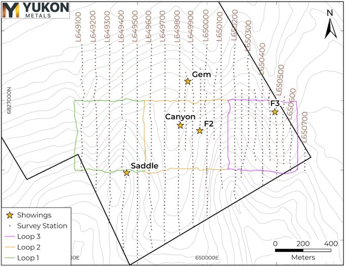
Figure 3- TDEM survey station and loop locations.
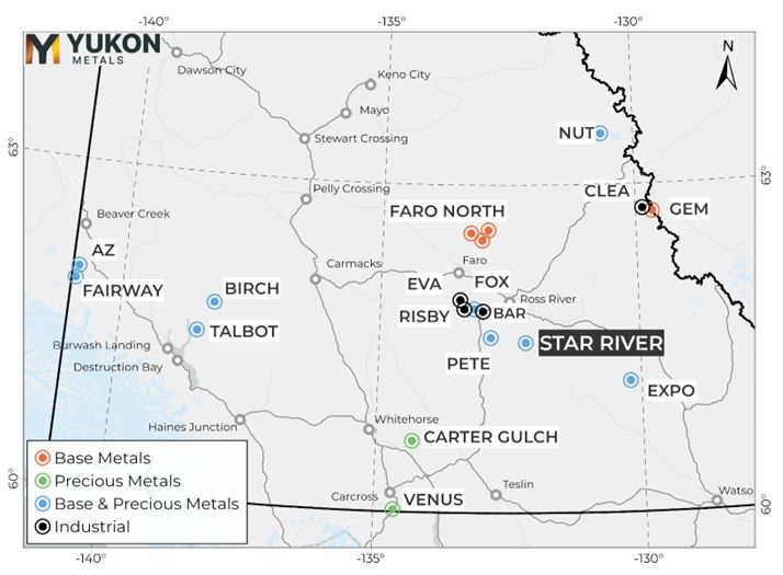
Figure 4- Star River Project Location Map
Qualified Person
The technical content of this news release has been reviewed and approved by Helena Kuikka, P.Geo., VP Exploration for Yukon Metals and a Qualified Person (as defined by National Instrument 43-101).
About Yukon Metals Corp.
Yukon Metals is well financed and represents a property portfolio built on over 30 years of prospecting by the Berdahl family, the prospecting team behind Snowline Gold's portfolio of primary gold assets . The Yukon Metals portfolio consists primarily of copper-gold and silver-lead-zinc assets, with a substantial gold and silver component.
The Company is led by an experienced Board of Directors and Management Team across technical and finance disciplines.
Yukon Metals is focused on fostering sustainable growth and prosperity within Yukon's local communities, while simultaneously enhancing stakeholder value. Our strategy centers around inclusivity and shared prosperity, offering both community members and investors the chance to contribute to, and benefit from, our ventures.
The Yukon
The Yukon ranks 10 th most prospective for mineral potential across global jurisdictions according to the Fraser Institute's 2023 Survey of Mining Companies, and is host to a highly experienced and conscientious local workforce, fostered by a long culture of exploration coupled with deep respect for the land. Recent major discoveries with local roots such as Snowline Gold's Rogue Project - Valley Discovery, demonstrate the Yukon's potential to generate fresh district-scale mining opportunities.
Yukon Metals CORP.
"Rory Quinn"
Rory Quinn, President & CEO
Email: roryquinn@yukonmetals.com
Tempelman-Kluit, D.J., 2012. Geology of the Quiet Lake and Finlayson Lake map areas, south-central Yukon – An early interpretation of bedrock stratigraphy and structure; Geological Survey of Canada, Open File 5487. Doi: 10.4095/291931
CAUTIONARY NOTE REGARDING FORWARD-LOOKING INFORMATION
This news release contains certain forward-looking information, including information about the metal association and geology of the prospect area at Star River, strong electromagnetic responses coincident with gold and silver sampling pointing to gold and silver deposits, the accuracy of the completed plate modelling and geophysical surveys, the potential for economic grades of silver and gold, Yukon's potential to generate fresh district-scale mining opportunities, and the Company's future plans and intentions. Wherever possible, words such as "may", "will", "should", "could", "expect", "plan", "intend", "anticipate", "believe", "estimate", "predict" or "potential" or the negative or other variations of these words, or similar words or phrases, have been used to identify the forward-looking information. These statements reflect management's current beliefs and are based on information currently available to management as at the date hereof.
Forward-looking information involves significant risks, uncertainties and assumptions. Many factors could cause actual results, performance or achievements to differ materially from those discussed or implied in the forward-looking information. Such factors include, among other things: risks and uncertainties relating to Star River not being a prospective gold-rich or silver-rich geological system; rock samples analysed not being representative of overall mineralization; the required assumptions of completed plate modelling results; not having significant scale and a lack of economic grade minerals; the Yukon not having the potential to generate fresh district-scale mining opportunities; and other risks and uncertainties. See the section entitled "Risk Factors" in the Company's listing statement dated May 30, 2024, available under the Company's profile on SEDAR+ at www.sedarplus.ca for additional risk factors. These factors should be considered carefully, and readers should not place undue reliance on the forward-looking information. Although the forward-looking information contained in this news release is based upon what management believes to be reasonable assumptions, the Company cannot assure readers that actual results will be consistent with the forward-looking information. The forward-looking information is made as of the date of this news release, and the Company assumes no obligation to update or revise the information to reflect new events or circumstances, except as required by law.
Photos accompanying this announcement are available at https://www.globenewswire.com/NewsRoom/AttachmentNg/6c132373-8487-49d4-905e-8adc54d6016f
https://www.globenewswire.com/NewsRoom/AttachmentNg/e50ec5e5-c8d1-474c-a463-08d4b7736ff1
https://www.globenewswire.com/NewsRoom/AttachmentNg/7614dfe6-3eff-4a8c-9739-5c26d4fb4b6e
https://www.globenewswire.com/NewsRoom/AttachmentNg/38e01c32-7bc5-4d85-8951-63e25f472f89
![]()