Talon Metals Makes Second Historic Discovery in a Month at Tamarack: 34.9 Meters of Massive Nickel Mineralization Intercepted in a New Zone

Most Significant Massive Nickel Mineralization Intercepted in Tamarack History in a Second New Zone Below the Tamarack Resource Area

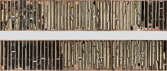
Talon Metals Corp. (TSX: TLO) (OTC Pink: TLOFF) (together with its subsidiaries, "Talon" or the "Company"), the majority owner and operator of the Tamarack Nickel-Copper-Cobalt Project ("Tamarack Nickel Copper Project") in central Minnesota, is pleased to announce a historic massive sulphide ("MSU") intercept measuring a cumulative 34.9 meters at the Tamarack Nickel Copper Project.

Cannot view this image? Visit: https://images.newsfilecorp.com/files/2443/251667_04828e98346709fa_001.jpg

Figure 1: Photo of drill core from drill hole 25TK0563 at 762.34 meters depth showing a cumulative 34.9 meters of massive nickel mineralization

To view an enhanced version of this graphic, please visit:
https://images.newsfilecorp.com/files/2443/251667_04828e98346709fa_001full.jpg

Highlights:

  • Drill hole 25TK0563 intercepted a cumulative length of 34.9 meters of massive nickel mineralization starting at 762.34 meters (over a total length of 47.33 meters).

  • The drill hole was targeting a series of Borehole Electromagnetic ("BHEM") anomalies identified from previous drill holes 25TK0562 and 16TK0250.

  • The previous record drilling thickness of MSU at the Tamarack Nickel Copper Project was 23.44 meters from drill hole 21TK0380 (see press release dated September 22, 2022).

  • The MSU in drill hole 25TK0563 appears to be very similar to the MSU in drill hole 16TK0250 extension suggesting grades may be similar (see Table 2).

  • Disseminated and vein mineralization above the MSU in drill hole 25TK0563 shows chalcocite and bornite suggesting high copper content similar to drill hole 16TK0250.

  • Drill hole 25TK0563 represents an approximate 68 meter step-out to the east from the intercept in drill hole 16TK0250.

  • BHEM surveys are currently being conducted on drill hole 25TK0563.

"In my 19 years working on the Tamarack Project, I've never seen anything like this. This 34.9-meter intercept of high-grade massive sulphide isn't just the longest ever recorded at Tamarack - it's a defining moment. It confirms what we've believed all along: that Tamarack is a truly world-class system. This project is essential to America's critical mineral independence, offering a domestic source of nickel and copper at a time when the United States needs it most," said Brian Goldner, Talon's Chief Exploration and Operations Officer.

Background

  • Since Talon's press release dated February 3, 2025, Talon's in-house exploration team has been 'Infilling' and 'Outfilling' the Tamarack Resource Area for purposes of completing a feasibility study at the Tamarack Nickel Copper Project. This work is in support of Talon's Proposed Action (a highly detailed project description) in its Environmental Assessment Worksheet to support the preparation of an Environmental Impact Statement.

  • Historic drill hole 16TK0250 was re-examined and extended from 649 meters depth in order to evaluate a subtle BHEM response observed in the data.

    • The drill hole encountered significant mineralization at a depth of 707.75 meters, intersection 8.25 meters grading 12.62% Ni, 13.88% Cu, 17.95g/t PGEs+Au (23.28% NiEq or 48.87% CuEq) (see the Company's press release dated May 1, 2025).

  • BHEM surveys of drill holes 16TK0250 and 25TK0562 identified multiple stacked BHEM anomalies which were targeted with drill hole 25TK0563.

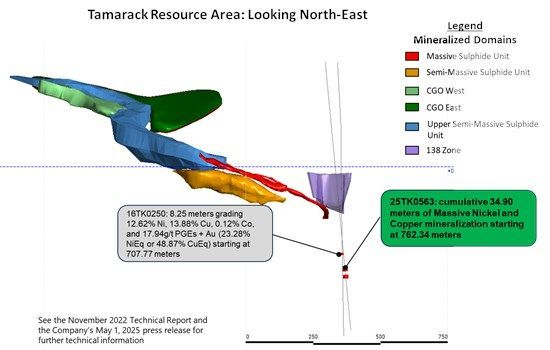
  • Drill hole 25TK0563 intersected the BHEM anomaly and intercepted 20.39 meters of Mixed and Massive Sulphide mineralization starting at 762.34 meters and 14.51 meters of Massive Sulphide mineralization starting at 795.16 meters for a cumulative intercept of 34.9 meters (see Figure 2).

Cannot view this image? Visit: https://images.newsfilecorp.com/files/2443/251667_04828e98346709fa_002.jpg

Figure 2: Tamarack Resource Area showing location of the new 34.9 meters intercept in relation to the mineralized domains

To view an enhanced version of this graphic, please visit:
https://images.newsfilecorp.com/files/2443/251667_04828e98346709fa_002full.jpg

QUALITY ASSURANCE, QUALITY CONTROL AND QUALIFIED PERSONS

Please see the technical report entitled "November 2022 National Instrument 43-101 Technical Report of the Tamarack North Project - Tamarack, Minnesota" with an effective date of November 2, 2022 ("November 2022 Technical Report") prepared by independent "Qualified Persons" (as that term is defined in National Instrument 43-101 ("NI 43-101")) Brian Thomas (P. Geo), Roger Jackson (P. Geo), Oliver Peters (P. Eng) and Christine Pint (P.G) for information on the QA/QC, data verification, analytical and testing procedures at the Tamarack Nickel Copper Project. Copies are available on the Company's website (www.talonmetals.com) or on SEDAR at (www.sedar.com). The laboratory used is ALS Minerals who is independent of the Company.

Lengths are drill intersections and not necessarily true widths. True widths cannot be consistently calculated for comparison purposes between holes because of the irregular shapes of the mineralized zones. Drill intersections have been independently selected by Talon. Drill composites have been independently calculated by Talon. The geological interpretations in this news release are solely those of the Company. The locations and distances highlighted on all maps in this news release are approximate.

Dr. Etienne Dinel, Vice President, Geology of Talon, is a Qualified Person within the meaning of NI 43-101. Dr. Dinel is satisfied that the analytical and testing procedures used are standard industry operating procedures and methodologies, and he has reviewed, approved and verified the technical information disclosed in this news release, including sampling, analytical and test data underlying the technical information.

Where used in this news release:

NiEq% = Ni% + Cu% x $4.00/$8.00 x Cu Recovery/Ni Recovery + Co% x $20.00/$8.00 x Co Recovery/Ni Recovery + Pt [g/t]/31.103 x $1,000/$8.00/22.04 x Pt Recovery/Ni Recovery + Pd [g/t]/31.103 x $1,000/$8.00/22.04 x Pd Recovery/Ni Recovery + Au [g/t]/31.103 x $2,000/$8.00/22.04 x Au Recovery/Ni Recovery + Ag [g/t]/31.103 x $20.00/$8.00/22.04 x Ag Recovery/Ni Recovery

CuEq% = Cu%+ Ni% x $8.00/$4.00 + Co% x $20.00/$4.00 + Pt [g/t]/31.103 x $1,000/$4.00/22.04 + Pd [g/t]/31.103 x $1,000/$4.00/22.04 + Au [g/t]/31.103 x $2,000/$4.00/22.04 + Ag [g/t]/31.103 x $20.00/$4.00/22.04

For Ni and Cu recoveries, please refer to the formulae in the November 2022 Technical Report. Recovery of Ni to the Cu concentrate was excluded from the NiEq calculation. The following recoveries were used for the other metals: 64.1% for Co, 82.5% for Pt, 69.3% for Pd and 72.6% for Au and Ag.

ABOUT TALON

Talon is a TSX-listed base metals company in a joint venture with Rio Tinto on the high-grade Tamarack Nickel-Copper-Cobalt Project located in central Minnesota. Talon's shares are also traded in the US over the OTC market under the symbol TLOFF. The Tamarack Nickel Project comprises a large land position (18km of strike length) with additional high-grade intercepts outside the current resource area. Talon has an earn-in right to acquire up to 60% of the Tamarack Nickel Project and currently owns 51%. Talon is focused on (i) expanding and infilling its current high-grade nickel mineralization resource prepared in accordance with NI 43-101 to shape a mine plan for submission to Minnesota regulators, and (ii) following up on additional high-grade nickel mineralization in the Tamarack Intrusive Complex. Talon has a neutrality and workforce development agreement in place with the United Steelworkers union. Talon's Battery Mineral Processing Facility in Mercer County was selected by the US Department of Energy for US$114.8 million funding grant from the Bipartisan Infrastructure Law and the US Department of Defense awarded Talon a grant of US$20.6 million to support and accelerate Talon's exploration efforts in both Minnesota and Michigan. Talon has well-qualified experienced exploration, mine development, external affairs and mine permitting teams.

For additional information on Talon, please visit the Company's website at www.talonmetals.com or contact:

  Media Contact:
 
Jessica Johnson
(218) 460-9345
johnson@talonmetals.com
Investor Contact:
 
Mike Kicis
1 (647) 968-0060
kicis@talonmetals.com


FORWARD-LOOKING STATEMENTS

This news release contains certain "forward-looking statements". All statements, other than statements of historical fact that address activities, events or developments that the Company believes, expects or anticipates will or may occur in the future are forward-looking statements. These forward-looking statements reflect the current expectations or beliefs of the Company based on information currently available to the Company. Such forward-looking statements include statements relating to future exploration work, including future drill results and assays as well as geological interpretations. Forward-looking statements are subject to significant risks and uncertainties and other factors that could cause the actual results to differ materially from those discussed in the forward-looking statements, and even if such actual results are realized or substantially realized, there can be no assurance that they will have the expected consequences to, or effects on the Company.

Any forward-looking statement speaks only as of the date on which it is made and, except as may be required by applicable securities laws, the Company disclaims any intent or obligation to update any forward-looking statement, whether as a result of new information, future events or results or otherwise. Although the Company believes that the assumptions inherent in the forward-looking statements are reasonable, forward-looking statements are not guarantees of future performance and accordingly undue reliance should not be put on such statements due to the inherent uncertainty therein.

Table 1: Collar Location of Drill Hole 25TK0563

Drill Hole
(#)
Easting
(m)
Northing
(m)
Elevation
(masl)
Azm Dip End Depth
(m)
25TK0563 491049.16 5168344.40 388.00 170.66 -84.56 867.77
Collar coordinates are UTM Zone 15N, NAD83.
Azimuths and dips are taken from the survey record at collar unless otherwise noted.


Table 2: Quick Lithology Log for Drill Hole 25TK0563

Drill Hole
(#)
From
(m)
To
(m)
Length
(m)
Quick Log %
Sulphides
25TK0563 0 33.02
OB
33.02 418.05
FGO/MZNO Traces
418.05 524.25 106.2 FGO/MZNO 5-10%
524.25 538.65
CGO 1-2%
538.65 539.14 0.49 MSU 95%
539.14 762.26
CGO Tr-3%
762.26 762.34
SED Tr
762.34 782.73 20.39 MMS/MSU 80%
782.73 783.26
SED
783.26 795.16
CGO
795.16 809.67 14.51 MSU 95%
809.65 826.01
SED
826.01 867.77
CGO Tr-3%
Quick lithology log of drill holes: Overburden (OB); Meta-sedimentary rocks (SED); Fine-grained Orthocumulate/Mixed Zone (FGO/MZNO); Coarse-grained Orthocumulate (CGO); Mixed and Massive sulphide (MMS/MSU).


To view the source version of this press release, please visit https://www.newsfilecorp.com/release/251667
News Provided by Newsfile via QuoteMedia

TLO:CC
The Conversation (0)

Talon Metals Submits Environmental Assessment Worksheet for Proposed Underground Nickel Mine to Produce Domestic Supply of Minerals for US Battery Supply Chain

Minnesota Department of Natural Resources will commence Environmental Review process for proposed underground mine, rail loading facility and water treatment plant in central Minnesota

Talon Metals Corp. (TSX: TLO) (OTC Pink: TLOFF) through its subsidiary Talon Nickel (USA) LLC ("Talon" or the "Company"), today submitted its Environmental Assessment Worksheet ("EAW") to the Minnesota Department of Natural Resources to begin the State's Environmental Impact Statement scoping process for the Tamarack Nickel-Copper-Cobalt Project (the "Tamarack Nickel Project"), a proposed small-footprint, high-grade underground nickel mine that would be located near the City of Tamarack in Aitkin County, Minnesota.

News Provided by Newsfile via QuoteMedia

Keep reading...Show less
Talon Metals Reports Results for the Quarter Ended March 31, 2023

Talon Metals Reports Results for the Quarter Ended March 31, 2023

Talon Metals Corp. (TSX: TLO) ("Talon" or the "Company") reported a net loss for the three months ended March 31, 2023 of $0.6 million or nil per share (basic and diluted), which was primarily the result of administration expenses and stock option compensation offset by interest income. This compares to a net loss for the three months ended March 31, 2022 of $1.2 million or nil per share (basic and diluted), which was primarily the result of administration expenses and stock option compensation.

Capitalized exploration costs and deferred expenditures on the Tamarack Nickel-Copper-Cobalt Project for the three months ended March 31, 2023 amounted to $11.7 million. This compares to $16.2 million for the three months ended March 31, 2022. The total capitalized exploration cost to the Tamarack Nickel-Copper-Cobalt Project to March 31, 2023 amounts to $172.1 million.

News Provided by Newsfile via QuoteMedia

Keep reading...Show less
Finlay Minerals completes Field Work on Newly Identified Geophysical Targets on the SAY and JJB Properties

Finlay Minerals completes Field Work on Newly Identified Geophysical Targets on the SAY and JJB Properties

finlay minerals ltd. (TSXV: FYL,OTC:FYMNF) (OTCQB: FYMNF) ("Finlay" or the "Company") is pleased to announce that the results from airborne magnetic surveys conducted over the SAY and JJB properties (refer to Figure 1 ), have identified significant northwest- and northeast-trending structures. These structures resemble those found in the Toodoggone area of British Columbia which is recognized for its potential to host larger porphyry and epithermal deposits. A total of 1,900 kilometres ("km") of airborne magnetic survey data was collected over the two properties.

Follow-up groundwork at the SAY property focused on the IFT target, where a large circular magnetic anomaly, measuring 2.5 km by 2.5 km, was identified. This anomaly displays geophysical signatures similar to those observed in other copper porphyry deposits. Additionally, a second kilometre-scale target, known as Ozzy, was identified. Ozzy is located at the intersection of a northeast-trending magnetic anomaly and a northwest-trending magnetic anomaly. Further follow-up work is planned for both targets.

The SAY property was acquired in 2024, and an inaugural field program concentrated on chip sampling and mapping along the 4.3-kilometer-long SPUR Trend last summer. This effort led to the discovery of the 200 m x 200 m copper-silver mineralized AG Zone and confirmed the continuity of high-grade copper-silver mineralization at the Spur Target.  Chip sampling at the AG Zone included 9.5 metres of 0.94% Cu and 18.1 g/t Ag . (1)

The JJB property was staked in February, 2025 for its porphyry potential. Three main copper showings—Squingula, Quin, and Pat—have been identified. Squingula and Quin are located near an Eocene intrusion on the western side, and show a coincident magnetic high linked to a multi-element geochemical anomaly from limited sampling. This summer, fieldwork focused on the PAT target, one of three potential targets. This work aimed to evaluate the similarities between the high-grade copper-silver mineralization found at JJB and the SPUR/AG targets within the SAY Property.

SAY & JJB Project Highlights:

SAY 2025 Program :

JJB 2025 Program :


•       Over 1,200 line-km of airborne magnetics

•       Completion of Finlay's inaugural field program


•       Completion of property-wide LiDAR survey

•       Completion of property-wide LiDAR survey


•       Completion of satellite mineral alteration survey (PhotoSat)

•       Completion of satellite mineral alteration survey (PhotoSat)


•       84 rock samples collected

•       700 line-km of airborne magnetics


•       307 soil samples collected

•       18 rock samples collected


•       275 biogeochemistry samples collected

•       35 soil and talus samples collected

Processing of the LiDAR and satellite mineral alteration data is on-going.  All field samples have been submitted to the laboratory for analysis with results pending.

Situated in the underexplored Bear Lake corridor, the SAY and JJB projects are part of a 135-kilometre geological corridor that includes American Eagle Gold's NAK project, as well as Amarc Resources and Boliden Mineral Canada's DUKE copper-molybdenum-silver-gold prospects.

PIL and ATTY Project Updates:

Exploration work at the PIL and ATTY Toodoggone projects is on-going and anticipated to be completed within the next two weeks with continued induced polarization geophysical surveys. The PIL and ATTY work is fully funded by Freeport-McMoRan Mineral Properties Canada Inc. under their respective Earn-In Agreements (2) with Finlay acting as the operator.

References:

  1. Finlay news release NR13-24 dated November 20, 2024 entitled: " Finlay Minerals samples 1.17% Cu and 103.5 g/t Ag across 21.7 meters of a Continuous Chip Sample on the SAY Property ".

  2. Finlay news releases NR03-25 dated April 17, 2025 entitled: " Finlay Minerals Enters into Earn-In Agreements with Freeport for its PIL & ATTY Properties " and NR 05-25 dated May 2, 2025 and entitled: " Finlay Minerals Receives TSX Venture Exchange Approval for PIL Earn-In Agreement. "

Qualified Person:

Wade Barnes , P. Geo. and Vice President, Exploration for Finlay Minerals and a qualified person as defined by National Instrument 43-101, has approved the technical content of this news release.

About finlay minerals ltd.

Finlay is a TSXV company focused on exploration for base and precious metal deposits through the advancement of its ATTY, PIL, JJB, SAY and Silver Hope Properties; these properties host copper-gold porphyry and gold-silver epithermal targets within different porphyry districts of northern and central BC. Each property is located in areas of recent development and porphyry discoveries with the advantage of hosting the potential for new discoveries.

Finlay trades under the symbol "FYL" on the TSXV and under the symbol "FYMNF" on the OTCQB. For further information and details, please visit the Company's website at www.finlayminerals.com

On behalf of the Board of Directors,

Robert F. Brown ,
Executive Chairman of the Board

Neither the TSXV nor its Regulation Services Provider (as that term is defined in the policies of the TSXV) accepts responsibility for the adequacy or accuracy of this release.

Forward-Looking Information: This news release includes certain "forward-looking information" and "forward-looking statements" (collectively, "forward-looking statements") within the meaning of applicable Canadian securities legislation. All statements in this news release that address events or developments that we expect to occur in the future are forward-looking statements.  Forward-looking statements are statements that are not historical facts and are generally, although not always, identified by words such as "expect", "plan", "anticipate", "project", "target", "potential", "schedule", "forecast", "budget", "estimate", "intend" or "believe" and similar expressions or their negative connotations, or that events or conditions "will", "would", "may", "could", "should" or "might" occur. All such forward-looking statements are based on the opinions and estimates of management as of the date such statements are made. Forward-looking statements in this news release include statements regarding, among others, the exploration plans for the Properties. Although Finlay believes the expectations expressed in such forward-looking statements are based on reasonable assumptions, such statements are not guarantees of future performance and actual results or developments may differ materially from those forward-looking statements. Factors that could cause actual results to differ materially from those in forward-looking statements include market prices, exploration successes, and continued availability of capital and financing and general economic, market or business conditions. These forward-looking statements are based on a number of assumptions including, among other things, assumptions regarding general business and economic conditions, the timing and receipt of regulatory and governmental approvals, the ability of Finlay and other parties to satisfy stock exchange and other regulatory requirements in a timely manner, the availability of financing for Finlay's proposed transactions and programs on reasonable terms, and the ability of third-party service providers to deliver services in a timely manner. Investors are cautioned that any such statements are not guarantees of future performance and actual results or developments may differ materially from those projected in the forward-looking statements, and accordingly undue reliance should not be put on such statements due to the inherent uncertainty therein. Finlay does not assume any obligation to update or revise its forward-looking statements, whether as a result of new information, future or otherwise, except as required by applicable law.

SOURCE finlay minerals ltd.

Cision View original content to download multimedia: http://www.newswire.ca/en/releases/archive/September2025/22/c1184.html

News Provided by Canada Newswire via QuoteMedia

Keep reading...Show less
Copper Quest Acquires the Nekash Copper-Gold Porphyry Project in Idaho, USA

Copper Quest Acquires the Nekash Copper-Gold Porphyry Project in Idaho, USA

// Not for distribution to the United States newswire services or for dissemination in the United States //

Copper Quest Exploration Inc. (CSE: CQX; OTCQB: IMIMF; FRA: 3MX) (" Copper Quest " or the " Company ") is pleased to announce that it has closed the previously announced acquisition of the Nekash Copper-Gold Porphyry Project (" Nekash " or the " Project ") located in Lemhi County, Idaho, United States. This acquisition marks an important milestone in the Company's strategy to build a portfolio of highly prospective copper assets across North America.

News Provided by GlobeNewswire via QuoteMedia

Keep reading...Show less
Silver47 Announces Grant of Stock Options and Restricted Share Units

Silver47 Announces Grant of Stock Options and Restricted Share Units

Silver47 Exploration Corp. (TSXV: AGA,OTC:AAGAF) (OTCQB: AAGAF) ("Silver47" or the "Company") announces that it has granted an aggregate of 5,300,000 incentive stock options (the "Options") and 180,000 Restricted Share Units ("RSUs") to certain directors, officers and consultants of the Company in accordance with the Company's omnibus security based compensation plan. The Options are exercisable at a price of C$0.78 and will expire five years from the date of grant and will vest on the date of grant. The RSUs will vest over two years starting on the first anniversary of grant.

About Silver47 Exploration

News Provided by Newsfile via QuoteMedia

Keep reading...Show less
Group Eleven Drills 6.5m of 217 g/t Ag and 0.34% Cu; and 2.6m of 19 g/t Ag, 1.07% Cu and 0.14% Sb, Confirming Deeper Cu-Ag  Mineralization at Ballywire

Group Eleven Drills 6.5m of 217 g/t Ag and 0.34% Cu; and 2.6m of 19 g/t Ag, 1.07% Cu and 0.14% Sb, Confirming Deeper Cu-Ag Mineralization at Ballywire

Group Eleven Resources Corp. (TSXV: ZNG,OTC:GRLVF) (OTCQB: GRLVF) (FSE: 3GE) ("Group Eleven" or the "Company") is pleased to announce results from its first hole testing the 'Deeper Cu-Ag Target' at its Ballywire discovery ("Ballywire") at the 100%-owned PG West Project ("PG West"), Republic of Ireland.

Highlights:

  • 25-3552-40 (filling a 160m gap in previous drilling, while testing the discovery horizon at the base of the Waulsortian Limestone and 250m below it) intersected intermittent mineralization over 240m, including:
    • Cu-Ag Intercept (hosted within the base of the Waulsortian Limestone)
    • 11.4m of 139 g/t Ag and 0.23% Cu (starting from 340.0m downhole), including
    • 6.5m of 217 g/t Ag and 0.34% Cu, including
    • 0.7m of 654 g/t Ag and 0.96% Cu and
    • 0.7m of 1,165 g/t Ag and 1.89% Cu
    • Cu-Ag Intercepts (at the 'Deeper Cu-Ag Target,' below the Waulsortian Limestone)
    • 2.8m of 26 g/t Ag and 0.39% Cu, (from 441.3m downhole), including
    • 1.8m of 34 g/t Ag and 0.53% Cu, including
    • 0.2m (17cm) of 148 g/t Ag and 2.59% Cu, and
    • 17.9m of 10 g/t Ag and 0.37% Cu, (from 516.9m downhole), including
    • 4.7m of 13 g/t Ag, 0.71% Cu and 0.09% Sb, including
    • 2.6m of 19 g/t Ag, 1.07% Cu and 0.14% Sb
  • Results confirm presence of Cu-Ag (Sb) mineralization in the 'Deeper Cu-Ag Target' below the base of the Waulsortian Limestone, in line with Group Eleven's exploration model
  • Two follow-up holes, to the NNW and SSE of the above hole, respectively, are underway
  • Cu-Ag (and locally Sb) mineralization consists of chalcopyrite and suspected tennantite-tetrahedrite occurring as disseminated mineralization and/or within calcite veins; mineralization appears to be related to a south-dipping fault zone (pierced by today's drill hole) which is associated with Zn-Pb-Ag mineralization stratigraphically higher up (at the base of the Waulsortian Limestone)

"This is the first test of our hypothesized 'Deeper Cu-Ag Target' and we are thrilled that it has borne fruit," stated Bart Jaworski, CEO. "With a viable new Cu-Ag target below our existing Zn-Pb-Ag horizon, our exploration potential has essentially doubled. We are gearing up to expand on this deeper discovery not only up and down dip, but also along our 2.6km-long strike-length of robust zinc mineralization pierced by drilling to date. As per our nearby geological analogues at Gortdrum, Denison and Tullacondra, fault-controlled Cu-Ag mineralization tends to strengthen with increased shattering along the structure. Further drilling at the 'Deeper Cu-Ag Target' will aim to identify these features. With three rigs turning each on excellent targets at Ballywire, a fourth rig likely to be added soon and a recently bolstered cash position, Group Eleven is poised to keep generating shareholder value through the drill bit for the foreseeable future."

Cannot view this image? Visit: https://images.newsfilecorp.com/files/5685/267324_groupelevenexhibit1_550.jpg

Exhibit 1. Cross Section of Deeper Cu-Ag Target Showing Hole 25-3552-40

To view an enhanced version of this graphic, please visit:
https://images.newsfilecorp.com/files/5685/267324_groupelevenexhibit1.jpg

Note: *Fence of holes G11-3552-25 to -31 is projected 60m onto the section plane; true thickness of intervals in 25-3552-40 as a percentage of down-hole interval, is estimated to be 80-100% (taking into account variability of vein orientations).

Cannot view this image? Visit: https://images.newsfilecorp.com/files/5685/267324_groupelevenexhibit2_550.jpg

Exhibit 2. Plan Map of Ballywire Discovery Showing New Drilling and Location of Above Section

To view an enhanced version of this graphic, please visit:
https://images.newsfilecorp.com/files/5685/267324_groupelevenexhibit2.jpg

Note: Hole 25-3552-38 returned trace sphalerite and galena over approx. 12m, near the base of the Waulsortian Limestone

Ballywire Drill Update

The Ballywire prospect at the Company's 100%-owned PG West Project in Republic of Ireland, represents the most significant mineral discovery in Ireland in over a decade. First announced in Sept-2022, the discovery has 59 holes drilled and reported by Group Eleven to date, including the most recent three holes (25-3552-38, -40 and -41) reported today (see Exhibits 1 to 4). Drilling to date at Ballywire has pierced robust mineralization over a 2.6km strike-length, along a prospective trend of over 6km (defined by four regional gravity-high anomalies, only one of which has been systematically drill tested to date; see Exhibit 4).

Today's results from hole 25-3552-40 confirm that Cu-Ag mineralization exists below the base of the Waulsortian Limestone, in line with Group Eleven's 'Deeper Cu-Ag Target' exploration model. Assay results are summarized in Exhibit 3. In addition to the description above, it is noteworthy that at least one large (19cm wide) tennantite-tetrahedrite-bearing calcite vein is bedding parallel, whereas other similar but narrower veins tend to be more irregular in orientation.

Two additional holes have been released today. Holes 25-3552-38 and -41, drilled 1.3km to the NE, near gravity-high anomaly 'D' (see Exhibits 2 and 4), also returned significant results.

Hole 25-3552-41 intersected what is interpreted as oxidized massive sulphide mineralization within a fault zone. Despite being highly weathered, the interval returned highly anomalous metal concentrations: (i) 7.9m of 0.74% Zn+Pb (0.57% Zn and 0.17% Pb) and 7.4 g/t Ag (starting at 229.5m downhole), including 0.9m of 2.87% Zn+Pb (2.43% Zn and 0.44% Pb) and 35.9 g/t Ag; and (ii) 12.0m of 0.13% Zn+Pb (0.06% Zn and 0.07% Pb) and 3.3 g/t Ag (starting at 258.2m downhole), including 1.1m of 0.55% Zn+Pb (0.21% Zn and 0.34% Pb) and 18.6 g/t Ag. These intervals (7.9m and 12.0m) contained weathered-out cavities totalling 19% and 40% of their respective downhole lengths (assumed 'nil' grade in the above weighted-average calculations). It is possible that these cavities represent evidence of preferential weathering due to original high levels of mineralization (e.g. massive sulphide). Hole 25-3552-38 returned trace sphalerite and galena (from approx. 231-244m downhole) near the base of the Waulsortian Limestone, also suggesting proximity to higher-grade mineralization.

Follow up drilling will resume at this locality once drill permits are received for the adjacent area, allowing more flexibility to systematically test the entire 'Anomaly D' target. This is the Company's first test of this target area and given the above results, exploration potential has been confirmed. Today's results, combined with: (a) mineralized historic hole 99-3352-5, (b) two shallow historic holes with abundant calcite (similar to calcite bodies associated with the massive sulphide at the discovery trend) and (c) the presence of the 'D' gravity anomaly itself (see Exhibit 4), add significantly to the prospectivity of this target.

Overall, three rigs are currently drilling at Ballywire, with a fourth rig expected soon. One rig continues to drill a fence of holes collared 200m east of hole G11-3552-08 (see Exhibit 2), testing for the easterly continuation of the mineralized trend. The second and third rigs are drilling along the section of holes containing G11-468-01 and 00-468-5 (see Exhibit 2) to test for a SW continuation of high-grade mineralization towards gravity-high anomaly 'B'. Depending on results, the next fence of drilling testing the 'Deeper Cu-Ag Target' may be from this section. The fourth rig is likely to be geared towards reconnaissance drilling further outboard of the current mineralized corridor.

Currently, twelve (12) new holes are completed or nearly completed (and in the process of being logged, sampled and assayed) as shown in Exhibit 2 (specifically, two holes near 25-3552-40; three holes near hole G11-3552-19; four holes collared approx. 200m NNW of G11-3552-08; and three holes on the drill fence hosting G11-468-01).

Exhibit 3. Summary of Assays from 25-3552-40 at Ballywire

Item From 
(m)
To 
(m)
Int 
(m)
Zn 
(%)
Pb 
(%)
Zn+Pb 
(%)
Ag 
(g/t)
Cu
(%)
Sb
(%)
25-3552-40 311.91 358.83 46.92 0.33 0.11 0.44 35.7 0.06 -
Incl. 339.96 351.35 11.39 0.66 0.22 0.88 138.8 0.23 0.02
Incl. 339.96 346.43 6.47 0.73 0.22 0.94 217.4 0.34 0.03
Incl. 339.96 340.66 0.70 2.64 0.27 2.91 654.0 0.96 0.09
Incl. 345.78 346.43 0.65 0.90 0.36 1.26 1,165.0 1.89 0.15
And 441.28 444.05 2.77 0.03 0.00 0.03 25.8 0.39 0.03
Incl. 442.23 444.05 1.82 0.04 0.00 0.04 33.9 0.53 0.04
Incl. 442.85 443.02 0.17 0.15 0.00 0.16 148.0 2.59 0.16
And 453.55 453.88 0.33 0.00 0.01 0.01 16.8 0.33 0.01
And 493.25 494.23 0.98 0.05 0.00 0.06 15.3 0.69 0.08
And 508.31 511.18 2.87 0.03 0.01 0.04 7.7 0.35 0.05
Incl. 510.18 511.18 1.00 0.05 0.00 0.05 13.6 0.69 0.09
And 516.89 534.81 17.92 0.03 0.00 0.03 10.0 0.37 0.05
Incl. 516.89 526.34 9.45 0.04 0.00 0.04 9.4 0.49 0.06
Incl. 521.62 526.34 4.72 0.05 0.00 0.06 12.7 0.71 0.09
Incl. 521.62 524.17 2.55 0.08 0.00 0.08 19.2 1.07 0.14
Incl. 523.98 524.17 0.19 0.32 0.00 0.32 72.2 4.36 0.47
And 531.40 533.85 2.45 0.02 0.00 0.02 24.0 0.28 0.04
And 546.82 552.31 5.49 0.01 0.01 0.02 8.0 0.12 0.01


Note: True thickness of the mineralized interval in holes 25-3552-40 as a percentage of the down-hole interval, is estimated to be 80-100% (taking into account variability of vein orientations)

Cannot view this image? Visit: https://images.newsfilecorp.com/files/5685/267324_groupelevenexhibit4_550.jpg

Exhibit 4. Regional Gravity Map Showing 6km Long Prospective Trend at Ballywire

To view an enhanced version of this graphic, please visit:
https://images.newsfilecorp.com/files/5685/267324_groupelevenexhibit4.jpg

Cannot view this image? Visit: https://images.newsfilecorp.com/files/5685/267324_groupelevenexhibit5_550.jpg

Exhibit 5. Regional Map of Ballywire Discovery and Surrounding Prospects

To view an enhanced version of this graphic, please visit:
https://images.newsfilecorp.com/files/5685/267324_groupelevenexhibit5.jpg

Notes to Exhibit 5: (a) Pallas Green MRE is owned by Glencore (see Glencore's Resources and Reserves Report dated December 31, 2024); (b) Stonepark MRE: see the 'NI 43-101 Independent Report on the Zinc-Lead Exploration Project at Stonepark, County Limerick, Ireland', by Gordon, Kelly and van Lente, with an effective date of April 26, 2018, as found on SEDAR; and (c) the historic estimate at Denison was reported by Westland Exploration Limited in 'Report on Prospecting Licence 464' by Dermot Hughes dated May, 1988; the historic estimate at Gortdrum was reported in 'The Geology and Genesis of the Gortdrum Cu-Ag-Hg Orebody' by G.M. Steed dated 1986; and the historic estimate at Tullacondra was first reported by Munster Base Metals Ltd in 'Report on Mallow Property' by David Wilbur, dated December 1973; and later summarized in 'Cu-Ag Mineralization at Tullacondra, Mallow, Co. Cork' by Wilbur and Carter in 1986; the above three historic estimates have not been verified as current mineral resources; none of the key assumptions, parameters and methods used to prepare the historic estimates were reported and no resource categories were used; significant data compilation, re-drilling and data verification may be required by a Qualified Person before the historic estimates can be verified and upgraded to be compliant with current NI 43-101 standards; a Qualified Person has not done sufficient work to classify them as a current mineral resource and the Company is not treating the historic estimates as current mineral resources. 'Rathdowney Trend' is the south-westerly projection of the Rathdowney Trend, hosting the historic Lisheen and Galmoy mines.

Qualified Person

Technical information in this news release has been approved by Professor Garth Earls, Eur Geol, P.Geo, FSEG, geological consultant at IGS (International Geoscience Services) Limited, and independent 'Qualified Person' as defined under Canadian National Instrument 43-101.

Sampling and Analytical Procedures

All core drilled at Ballywire is NQ (47.6mm) and is cut using a rock saw. Sample intervals vary between 0.17m to 1.41m with an average (over 243 samples) of 0.93m. The half-core samples are bagged, labelled and sealed at Group Eleven's core store facility in Limerick, Ireland. Selected sample bags are examined by the Qualified Person. Transport is via an accredited courier service and/or by Group Eleven staff to ALS Laboratories in Loughrea Co. Galway, Ireland. Sample preparation at the ALS facility comprises fine crushing 70%

Quality Assurance/Quality Control (QA/QC) Information

Group Eleven inserts certified reference materials ("CRMs" or "Standards") as well as blank material, to its sample stream as part of its industry-standard QA/QC programme. The QC results have been reviewed by the Qualified Person, who is satisfied that all the results are within acceptable parameters. The Qualified Person has validated the sampling and chain of custody protocols used by Group Eleven.

About Group Eleven Resources

Group Eleven Resources Corp. (TSXV: ZNG,OTC:GRLVF) (OTCQB: GRLVF) and (FSE: 3GE) is drilling the most significant mineral discovery in the Republic of Ireland in over a decade. The Company announced the Ballywire discovery in September 2022, demonstrating high grades of zinc, lead, silver, copper, germanium and locally, antimony. Key intercepts to date include:

  • 10.8m of 10.0% Zn+Pb and 109 g/t Ag (G11-468-03)
  • 10.1m of 8.6% Zn+Pb and 46 g/t Ag (G11-468-06)
  • 10.5m of 14.7% Zn+Pb, 399 g/t Ag and 0.31% Cu (G11-468-12)
  • 11.2m of 8.9% Zn+Pb and 83 g/t Ag (G11-3552-03)
  • 29.6m of 10.6% Zn+Pb, 78 g/t Ag and 0.15% Cu (G11-3552-12) and
  • 11.8m of 11.6% Zn+Pb, 48 g/t Ag (G11-3552-18)
  • 15.6m of 11.6% Zn+Pb, 122 g/t Ag and 0.19% Cu (G11-3552-27)
  • 12.0m of 1.4% Zn+Pb, 560 g/t Ag, 2.30% Cu and 0.17% Sb (25-3552-31), including
  • 6.4m of 2.1% Zn+Pb, 838 g/t Ag, 3.72% Cu and 0.27% Sb (25-3552-31)
  • 39.7m of 9.5% Zn+Pb, 131 g/t Ag and 0.27% Cu (25-3552-35)

Ballywire is located 20km from Company's 77.64%-owned Stonepark zinc-lead deposit1, which itself is located adjacent to Glencore's Pallas Green zinc-lead deposit2. The Company's two largest shareholders are Michael Gentile (14.2%) and Glencore Canada Corp. (14.1% interest). Additional information about the Company is available at www.groupelevenresources.com.

ON BEHALF OF THE BOARD OF DIRECTORS
Bart Jaworski, P.Geo.
Chief Executive Officer

E: b.jaworski@groupelevenresources.com | T: +353-85-833-2463
E: j.lau@groupelevenresources.com | T: 604-781-4915

Neither TSX Venture Exchange nor its Regulation Services Provider (as that term is defined in the policies of the TSX Venture Exchange) accepts responsibility for the adequacy or accuracy of this release.

Cautionary Note Regarding Forward-Looking Information

Technical and scientific information disclosed from neighbouring properties does not necessarily apply to the current project or property being disclosed. This press release contains forward-looking statements within the meaning of applicable securities legislation. Such statements include, without limitation, statements regarding the future results of operations, performance and achievements of the Company, including the timing, content, cost and results of proposed work programs, the discovery and delineation of mineral deposits/resources/ reserves and geological interpretations. Although the Company believes that such statements are reasonable, it can give no assurance that such expectations will prove to be correct. Forward-looking statements are typically identified by words such as: believe, expect, anticipate, intend, estimate, postulate and similar expressions, or are those, which, by their nature, refer to future events. The Company cautions investors that any forward-looking statements by the Company are not guarantees of future results or performance, and that actual results may differ materially from those in forward looking statements as a result of various factors, including, but not limited to, variations in the nature, quality and quantity of any mineral deposits that may be located. All of the Company's public disclosure filings may be accessed via www.sedarplus.ca and readers are urged to review these materials, including the technical reports filed with respect to the Company's mineral properties.

News Provided by Newsfile via QuoteMedia

Keep reading...Show less
Copper Quest Closes Second and Final Tranche of Financing

Copper Quest Closes Second and Final Tranche of Financing

// Not for distribution to the United States newswire services or for dissemination in the United States //

Copper Quest Exploration Inc. (CSE: CQX; FRA: 3MX) (" Copper Quest " or the " Company ") is pleased to announce that it has closed the second and final tranche (the " Second Tranche ") of its previously announced non-brokered private placement (the " Private Placement ") with the issuance of 4,070,534 units (the " Units ", and each, a " Unit ") of the Company at a price of $0.075 per Unit for gross proceeds of $305,290.05.

News Provided by GlobeNewswire via QuoteMedia

Keep reading...Show less

Latest Press Releases

Related News