Basin Energy

Priority Targets Identified At Marshall Uranium Project

Basin Energy Limited (ASX:BSN) (‘Basin’ or the ‘Company’) is pleased to provide an update on its Marshall Project (the ‘Project’) located in the southeastern part of the world-class Athabasca Basin (Figure 1).


Key Highlights

  • 3D inversion of historical geophysical datasets completed1
    • Multiple priority anomalies identified above and below the Athabasca unconformity in both sandstone and basement stratigraphy at Marshall
  • Positive uranium market sentiment continues to build, with U3O8 SPOT price exceeding US$70/Lb
  • Work continues at Geikie Project following maiden drilling program, with airborne gravity survey results expected in October
  • Basin remains funded for next round of exploration drilling
As part of our ongoing assessment of the Project, the Company engaged geophysical experts Computational Geosciences Inc. and Convolutions Geoscience to conduct modern 3D inversion and processing works of historic geophysical data. This work has identified multiple geophysical anomalies above and below the Athabasca unconformity within the sandstone and basement stratigraphy at the Marshall Project. The identification of these anomalies is highly encouraging given that little exploration has ever been conducted on these tenements. Basin will utilise these interpretations as a basis for future exploration works, in conjunction with the ongoing works at Geikie.

Basin’s Managing Director, Pete Moorhouse, commented“Basin has continued advancing the Marshall Project through the reprocessing of historic geophysical data – this is a continuation of the recently updated work at North Millennium which identified a significant unconformity target.

The identified sandstone conductivity anomalies, with corresponding basement anomalies provide immediate targets for Athabasca unconformity and basement hosted uranium mineralisation exploration and we are very excited with the results from the review of the historical data.

Combined with Basin’s recent work at North Millennium, the studies support our prospectivity analysis for this area, located within the heartland of the traditional uranium discoveries of the eastern Athabasca.

With U3O8 spot prices continuing to surge, we are positioning Basin in the enviable position of having multiple top-quality exploration targets in the world’s best uranium jurisdiction.”

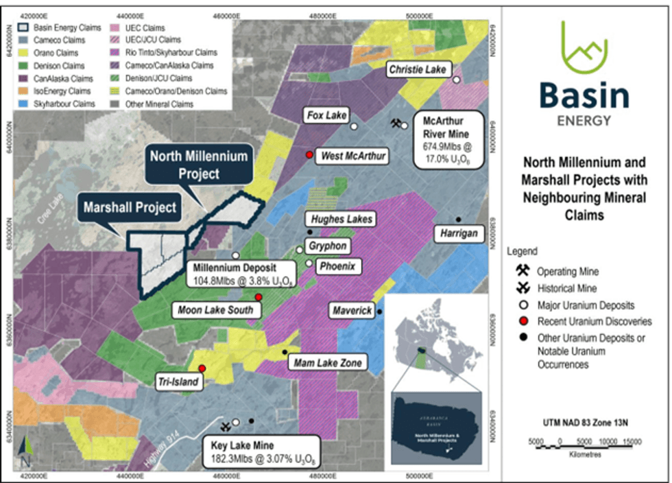
Figure 1: North Millennium and Marshall tenements with neighbouring tenements and uranium deposits.


Current Interpretation of the Marshall Project

The 100% owned Marshall project is located in the southeastern portion of the Athabasca Basin and situated 11 km west of the Millennium deposit, around 50 km southwest of the McArthur River mine.

Minimal historical mineral exploration at the Project occurred between 1979 to 2012, and there are no known historical exploration drill holes. Historical geophysical exploration work was limited to regional- scale airborne surveys, and small-scale airborne and ground-based electromagnetic surveys.

The depth of the unconformity is estimated to be between 700 and 900 metres. Z‐Tipper Axis Electromagnetics (“ZTEM”) was the only geophysical method used to date that appears to accurately detect the location of graphitic basement conductors.

The Marshall Project is centred on an arc-shape magnetic low feature outlined by airborne and ground geophysics. Interpretation of ZTEM and Transient Electromagnetic survey data shows conductive anomalies along the edge of the magnetic low and suggests a deep-rooted fold bearing conductive layers.

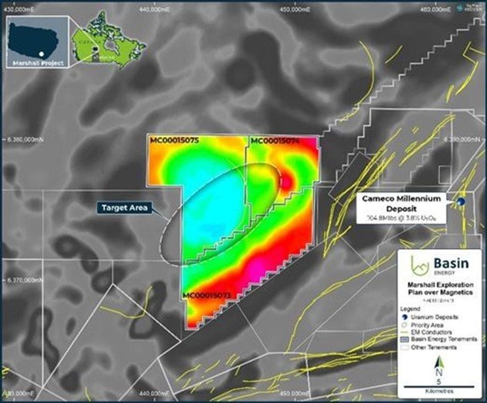
Figure 2: Marshall Project Exploration Plans (left) and Cameco’s Millennium Deposit type section (right)3.

3D Inversion of ZTEM data

Computational Geosciences Inc. was contracted to invert a ZTEM dataset collected over Kodiak Exploration’s historical McTavish project partially covering the Marshall mineral claims (Figure 3 and 4). ZTEM is an airborne electromagnetic geophysical technique which detects anomalies in the earth’s natural magnetic field. ZTEM surveys are designed to map resistivity contrasts to great depths, exceeding 1-2 km, making the technique well-suited to unconformity related uranium mineralisation exploration in the Marshall Project area.

3D models of electric conductivity have been produced, accounting for survey geometry and topography, and constrained by a basin-wide unconformity surface. The ZTEM inversion model 200 m below the modelled unconformity surface shows strong conductive anomalies along the edge of the magnetic low (Figure 3) Basin is currently interpreting this arc-shape feature as a deep-rooted fold reminiscent of Mudjatik deformation events. In addition to this, the data highlights a set of north northwest conductive anomalies which are interpreted as possible cross-cutting conductive structures. ZTEM 3D inversion 200 m above the unconformity (Figure 4) shows a number of relative conductivity anomalies in the sandstone, including a NE-SW structure set also highlighted by magnetic data. Basin interprets this to represent the potential presence of alteration within the sandstone, which could have been caused by mineralizing fluids breaching the unconformity contact.


Click here for the full ASX Release

This article includes content from Basin Energy, licensed for the purpose of publishing on Investing News Australia. This article does not constitute financial product advice. It is your responsibility to perform proper due diligence before acting upon any information provided here. Please refer to our full disclaimer here.

BSN:AU
Basin Energy

Basin Energy Investor Kit

  • Corporate info
  • Insights
  • Growth strategies
  • Upcoming projects

GET YOUR FREE INVESTOR KIT

The Conversation (0)
Basin Energy Logo

Basin Energy


Keep reading...Show less

Developing High-Grade Uranium Projects in the Athabasca Basin

Basin Energy Ltd  Rock Chip Results Confirm Polymetallic Potential

Basin Energy Ltd Rock Chip Results Confirm Polymetallic Potential

Perth, Australia (ABN Newswire) - Basin Energy Limited (ASX:BSN) (OTCMKTS:BSNEF) is pleased to report that it has received rock chip assay results for its Prastrun and Hakantorp projects in northwestern and south-central Sweden, respectively (Figure 1*). While focus in Q4 2024 was on field reconnaissance mapping of the northern Sweden projects Virka, Ravaberget and Bjorkberget, the late winter onset allowed Basin's field team to proceed with short prospect visits to the Hakantorp and Prastrun projects.

Key Highlights

- Positive results received from initial reconnaissance field mapping and rock chip program results at the Prastrun and Hakantorp projects in Sweden received.

- Niobium, uranium and tantalum mineralisation highlighted at Prastrun:
o Assay results up to 0.43% Nb (4350ppm) and 0.12% U3O8 (1153 ppm)

- Rare earth elements and uranium mineralisation identified from samples taken from interpreted tailings piles near Frakengruvan historical iron ore pit at Hakantorp

o HAK-003: 0.33 % U3O8 (3183 ppm), 0.33% TREO (3336 ppm)
o HAK-001: 0.39% U3O8 (3867 ppm), 0.21% TREO (2094 ppm)
o HAK-002: 0.20% U3O8 (1998 ppm), 0.27% TREO (2721 ppm)

- Structural core logging and multi-element assay sample on-going on Virka historical drillholes

Of nine samples collected at Hakantorp, five samples returned strongly anomalous total rare earth element oxides ("TREO") with two of these samples comprising uranium oxide values above 3000 ppm (Figure 3*). Assay results from the Prastrun project confirmed anomalous niobium, uranium and tantalum on three samples with results up to 4350 ppm niobium, 1153 ppm uranium oxide and 185 ppm tantalum.

Refer to Appendix two and three for full details*.

Basin's Managing Director, Pete Moorhouse, commented:

"The latest multi-element assay results are highly encouraging, confirming the potential presence of strategically important minerals within a multi-element mineral system.

With growing global demand for critical minerals essential to clean energy technologies, including nuclear power and advanced materials, these results position our project as a potential strategic asset. We look forward to integrating these results into our broader exploration model and continuing costeffective field work as the next steps to establish the full potential of these mineral-rich systems."

The Hakantorp project is located in south-central Sweden within the southern Bergslagen Zn-Pb-Ag and Fe-Co-Ni province, one of Sweden's most important provinces for the exploitation of metallic mineral resources (Figure 2*). The province includes Lundin Mining's (TSE:LUN) Zinkgruvan Zn-Pb-(AgCu) mine, approximately 10 kilometre southeast of Hakantorp, as well as the Zinkgruvan deposit where large-scale mining commenced in 1857 and is still ongoing today with ore production in 2024 totalling 1.43 million tons.

Numerous small skarn iron ore deposits were mined in the 19th century in the project area (Figure 2* and Figure 3*). Uranium occurrences were first reported in the 1950's through examining radioactive historical mine tailings. Follow-up investigations consisting of uraniferous sample collection from waste dumps and select open pits which had been drained (Figure 4*), returned U3O8 values in the 3-4% range.

Basin Energy conducted a short field visit to the project in Q4 2024. Strongly anomalous uranium oxides and TREO assays were returned from what appeared to be tailings near the historical Frakengruvan iron ore pit (Figure 3*):

- HAK-003: 3183 ppm U3O8, 3336 ppm TREO
- HAK-001: 3867 ppm U308, 2094 ppm TREO
- HAK-002: 1998 ppm U3O8, 2721 ppm TREO

Elevated TREO assays up to 837 ppm were also returned from two separate samples near Hank-Olles gruvan (HAK-004) and Torrgruvorna (HAK-006) pits.

Uranium mineralisation distribution in the area is poorly understood however, historical workings indicate uranium mineralisation appears to be structurally bound to a WNW trending structure zone.

Age determination on uranium mineralisation from samples collected in the 1950's concluded the most probable age was 1.785 million years during late-Svecofennian times.

The Company's priority at Hakantorp is to establish both surface and subsurface extensions of the rare earth and uranium rich skarn layers. Further field reconnaissance including structural mapping where feasible, and magnetic and radiometric surveys are considered as next steps in 2025 for the project.

Polymetallic prospectivity assessment at Prastrun, Northwest Sweden

The Prastrun project is located in Jamtland County, in northwestern Sweden, approximately 25 kilometres from the Norwegian border. The region is known for its polymetallic deposits, including uranium, vanadium, molybdenum, nickel, copper, zinc, and potash minerals.

Exploration conducted in the 1980's by the Swedish Geological Survey (SGU) at Prastrun highlighted anomalous results in rock chip samples up to 1.2% niobium, 0.45% U3O8, 0.07% tantalum, and 0.26% zirconium(Figure 5*, Appendix 2*). Sampling at the time occurred within anomalous outcrops over a 1,400-metre strike length, with the remainder of the prospect being covered by a thin glacial till.

Mineralisation is present as betafite (a uranium-niobium-tantalum mineral) hosted in nepheline syenite gneiss of the Seve nappe of the Caledonian tectonic zone. No drilling is known to have been completed at the prospect, however high quality geological and mineralogical studies were completed.

Previous claim holder Mawson Energi AB, a former subsidiary of Mawson Gold Limited, Now Southern Cross Gold Limited (ASX:SXG), completed a field visit6 at Prastrun in 2010 where a total of six samples were collected out of three sites (Figure 5*). Assay results on these samples highlighted anomalous niobium up to 5250 ppm, uranium oxide up to 728 ppm and tantalum up to 282 ppm (Appendix 2*).

Basin conducted a short two-day field visit in Q4 2024 to attempt to locate additional syenite gneiss outcrops, however the vegetation cover appears extremely dense in the project area and outcrops/boulder fields exposure was very low. Three rock chip samples were collected from a syenite outcrop 130 m north of historical sample site (Figure 5*) with assay results returning anomalous niobium, uranium and tantalum:

- PRAS-003: 3480 ppm Nb, 1153 ppm U3O8, 185 ppm Ta, 1330 ppm Zn from a boulder at the base of the outcrop sampled in PRAS-003

- PRAS-001: 2750 ppm Nb, 658 ppm U3O8, 146 ppm Ta, 1030 ppm Mn from a boulder at the base of the outcrop sampled in PRAS-003

- PRAS-002: 4350ppm Nb, 336 ppm U3O8, 74 ppm Ta from a syenite outcrop

Further field work at Prastrun is needed to delineate the extent of the anomalous betafite bearing syenite. Scintillometer surveying of syenite outcrops presumed locations (covered by moss) returned higher than background values. A systematic ground radiometric survey and further rock chip sampling would be an excellent tool to map out the surface extent of betafite-bearing lithologies.

Virka/Bjork/Rava Projects Update

While field mapping activities have halted for the winter, historical core relogging and sampling continues. Revisiting historical core through relogging and sampling represents a critical step in refining Basin's geological understanding of the projects area. Detailed structural analysis will help delineate key deformation events, fault structures, and fluid pathways that may have influenced multi-phase mineralisation. Using modern multi-element geochemical analysis is instrumental in understanding the ore systems at play in the area. These findings will help optimising future exploration strategies and drill targeting.

Finland Reservation Update

On 31st October 2024, Basin announced the execution of an agreement for the 100% acquisition of a portfolio of projects within Scandinavia. In addition to the five exploration licenses in Sweden that Basin has actively been assessing, the portfolio included 5 reservations in Finland. Following review of available data, Basin has elected to proceed with the application for exploration licenses over the Lotto, Temo and Palmottu projects and withdraw from the Eronlampi and Puokio projects.

*To view tables and figures, please visit:
https://abnnewswire.net/lnk/F9U801RL


About Basin Energy Ltd:  

Basin Energy Ltd (ASX:BSN) (OTCMKTS:BSNEF) is a green energy metals exploration and development company with an interest in three highly prospective projects positioned in the southeast corner and margins of the world-renowned Athabasca Basin in Canada and has recently acquired a significant portfolio of Green Energy Metals exploration assets located in Scandinavia.


Source:
Basin Energy Ltd

News Provided by ABN Newswire via QuoteMedia

Keep reading...Show less
Virka Project Sampling Returns High-Grade Mineralisation

Virka Project Sampling Returns High-Grade Mineralisation

Basin Energy (BSN:AU) has announced Virka Project Sampling Returns High-Grade Mineralisation

Download the PDF here.

High-Grade Mineralisation Identified at North Sweden Project

High-Grade Mineralisation Identified at North Sweden Project

Basin Energy (BSN:AU) has announced High-Grade Mineralisation Identified at North Sweden Project

Download the PDF here.

Granted Trollberget Licence Doubling Landholding

Granted Trollberget Licence Doubling Landholding

Basin Energy (BSN:AU) has announced Granted Trollberget Licence Doubling Landholding

Download the PDF here.

Basin Energy

Basin Energy Investor Kit

  • Corporate info
  • Insights
  • Growth strategies
  • Upcoming projects

GET YOUR FREE INVESTOR KIT

Latest Press Releases

Related News

×