The Conversation (0)

(TheNewswire)
 | |||||||||
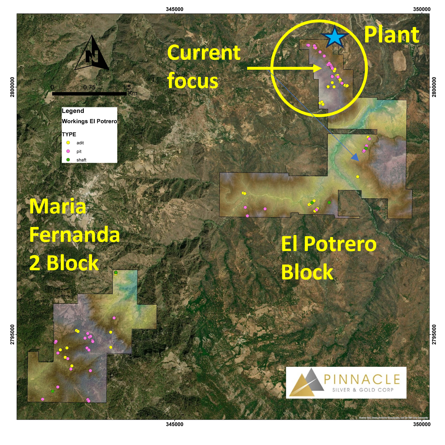
VANCOUVER, BRITISH COLUMBIA TheNewswire - January 6, 2026 - (TSXV: PINN,OTC:PSGCF, OTC: PSGCF, Frankfurt: P9J) Pinnacle Silver and Gold Corp. ("Pinnacle" or the "Company") is pleased to announce that the airborne LiDAR survey recently flown over the high-grade El Potrero gold-silver project in Durango, Mexico (see Pinnacle news release of November 24, 2025) has confirmed known structural trends, outlined previously unknown structures, and identified a total of 64 adits, 6 shafts and 51 prospecting pits on the two claim blocks comprising the project.
"The LiDAR survey was highly successful in confirming the 1,600 metre known strike length of the Dos de Mayo vein system and, perhaps more importantly, has identified new structures, often with artisanal workings that may indicate the presence of vein material," stated Robert Archer, Pinnacle's President & CEO. "The sheer number of historic shafts, adits and pits interpreted from the LiDAR survey underscores the prospectivity of the project and, to date, we have focused only on the northernmost 10% of the property. As such, we are adding to our geological team to follow up on these new targets."
Click Image To View Full Size
Figure 1: El Potrero Project Showing Two Claim Blocks and Artisanal Workings Interpreted from LiDAR
Click Image To View Full Size
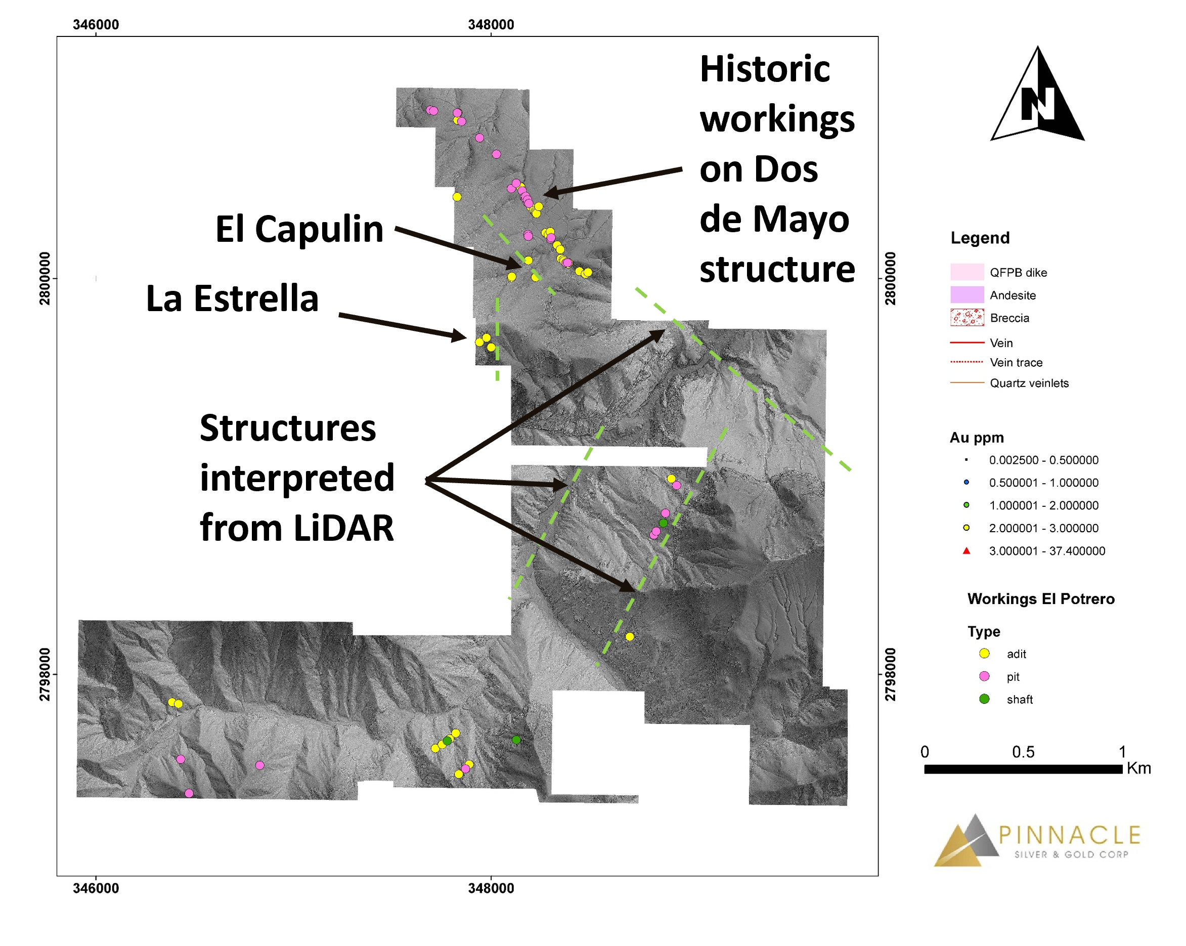
Figure 2: El Potrero Block Showing Artisanal Workings Interpreted from LiDAR Defining Main Dos de Mayo Trend and New Target Areas
On the northern, or ‘El Potrero', claim block (Figure 2), the majority of the 3 shafts, 50 adits and 29 pits clearly outline the known trace of the Dos de Mayo vein system and the more limited exposures of the El Capulin and La Estrella veins. However, the LiDAR also indicates the potential for an extension to this system to the southeast, across the river valley, where it would be hosted in similar andesitic rocks. In addition, there appears to be a previously unknown northeast-southwest trend on the southeast side of the valley, also in andesites, while similar northeast-southwest trends are observed in the southwest section, presumably hosted by intrusive rocks according to government regional geology maps. This latter scenario could give rise to a different, intrusive-related, style of mineralization. Regionally, northeast-trending structures pre-date the northwesterly trend and are host to the Ag-Pb-Zn-Au veins of the Topia Mine, 13 kilometres to the southwest.
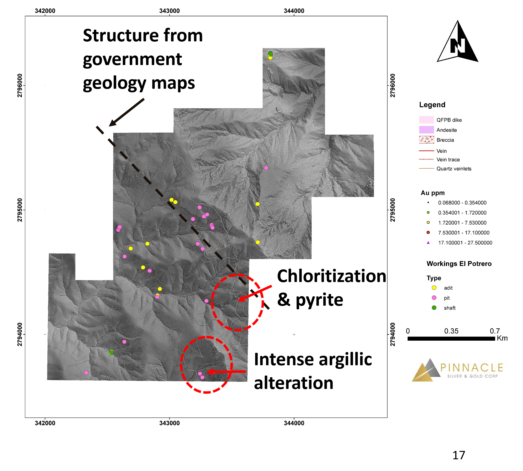
On the separate Maria Fernanda 2 (‘MF2') claim block to the southwest (Figure 3), 3 shafts, 14 adits and 22 pits are somewhat scattered across the concession. While this area has never been explored by modern methods, government maps indicate a northwest-southeast trending structure passing through the middle of the block, parallel to the Dos de Mayo system and to the regional structural trend. The LiDAR also indicates a number of smaller structures perpendicular to this trend. The road from Topia passes through the middle of the block and road cuts locally display intense argillic alteration and pervasive chloritization with minor pyrite that, collectively, may be indicative of a buried hydrothermal system. Several of the pits interpreted from the LiDAR appear to lie in close proximity to this zone. Pinnacle's geological team is planning a systematic and thorough evaluation of the area, commencing early in the New Year.
Click Image To View Full Size
Figure 3: MF2 Block Showing Artisanal Workings Interpreted from LiDAR, Structure and Alteration
The LiDAR survey covered the entire 11 km2 property and was flown by Eagle Mapping Ltd. of Langley, British Columbia. Reprocessing and interpretation of the data was conducted by GeoCloud Analytics of Melbourne, Australia.
LiDAR, or Light Detection and Ranging, is a remote sensing technology that uses laser light to ‘see through' vegetation and soil cover to measure distances, with 15-30 cm scale accuracy, to underlying rock surfaces. In this way, it can map out features such as structures and lithological contacts that can be related to mineralization but may not be exposed at surface. The survey also included colour aerial photography with 10-15 cm resolution that will assist in surface exploration and planning of infrastructure upgrades.
Qualified Person
Mr. Jorge Ortega, P. Geo, a Qualified Person as defined by National Instrument 43-101, and the author of the NI 43-101 Technical Report for the Potrero Project, has reviewed, verified and approved for disclosure the technical information contained in this news release.
About the Potrero Property
El Potrero is located in the prolific Sierra Madre Occidental of western Mexico and lies within 35 kilometres of four operating mines, including the 4,000 tonnes per day (tpd) Ciénega Mine (Fresnillo), the 1,000 tpd Tahuehueto Mine (Luca Mining) and the 250 tpd Topia Mine (Guanajuato Silver).
High-grade gold-silver mineralization occurs in a low sulphidation epithermal breccia vein system hosted within andesites of the Lower Volcanic Series and has three historic mines along a 500 metre strike length. The property has been in private hands for almost 40 years and has never been systematically explored by modern methods, leaving significant exploration potential.
A previously operational 100 tpd plant on site can be refurbished / rebuilt and historic underground mine workings rehabilitated at relatively low cost in order to achieve near-term production once permits are in place. The property is road accessible with a power line within three kilometres.
Pinnacle will earn an initial 50% interest immediately upon commencing production. The goal would then be to generate sufficient cash flow with which to further develop the project and increase the Company's ownership to 100% subject to a 2% NSR. If successful, this approach would be less dilutive for shareholders than relying on the equity markets to finance the growth of the Company.
About Pinnacle Silver and Gold Corp.
Pinnacle is focused on the development of precious metals projects in the Americas. The high-grade Potrero gold-silver project in Mexico's Sierra Madre Belt hosts an underexplored low-sulphidation epithermal vein system and provides the potential for near-term production. In the prolific Red Lake District of northwestern Ontario, the Company owns a 100% interest in the past-producing, high-grade Argosy Gold Mine and the adjacent North Birch Project with an eight-kilometre-long target horizon. With a seasoned, highly successful management team and quality projects, Pinnacle Silver and Gold is committed to building long-term, sustainable value for shareholders.
Signed: "Robert A. Archer"
President & CEO
For further information contact:
Email: info@pinnaclesilverandgold.com
Tel.: +1 (877) 271-5886 ext. 110
Website: www.pinnaclesilverandgold.com
Neither the TSX Venture Exchange nor the Investment Industry Regulatory Organization of Canada accepts responsibility for the adequacy or accuracy of this release.
Copyright (c) 2026 TheNewswire - All rights reserved.
News Provided by TheNewsWire via QuoteMedia