Noble Minerals Announces Drilling Results from Noble Minerals-Canada Nickel Joint Venture

Noble Minerals Announces Drilling Results from Noble Minerals-Canada Nickel Joint Venture

(TheNewswire)

Noble Mineral Exploration Inc.

Highlights

  • Drill Program completed on the Mann and Reaume Properties, part of the Noble Minerals-Canada Nickel Joint Venture (ExploreCo)

  • Mann Central Property: Drill results include 223 meters of 0.29% nickel including 10 meters of 0.51% nickel

  • Mann West Property: Drilling successfully delineated mineralization over a 1,700 meter strike length and 600 meters width

  • First assays from 2024 drilling at Mann West yield excellent results including 330 metres of 0.26% nickel in MAN24-58 including a total of 24.5 metres of 0.35% nickel; initial resource estimate expected by Q1 2025

  • Multiple gold intervals in Mann North drilling including 4.5 metres of 2.36 g/t gold within 45 metres of 0.45 g/t gold at MAN24-67

  • Reaume Property: Drilling indicated an improved nickel grade

Toronto, Ontario – TheNewswire - October 31, 2024 – Noble Mineral Exploration Inc. ( "Noble" or the "Company" ) (TSX-V:NOB, FRANKFURT: NB7, OTCQB:NLPXF) is pleased to announce results of a drill program on joint venture properties (ExploreCo) north of Timmins Ontario (See Canada Nickel Press Release dated October 31, 2024).

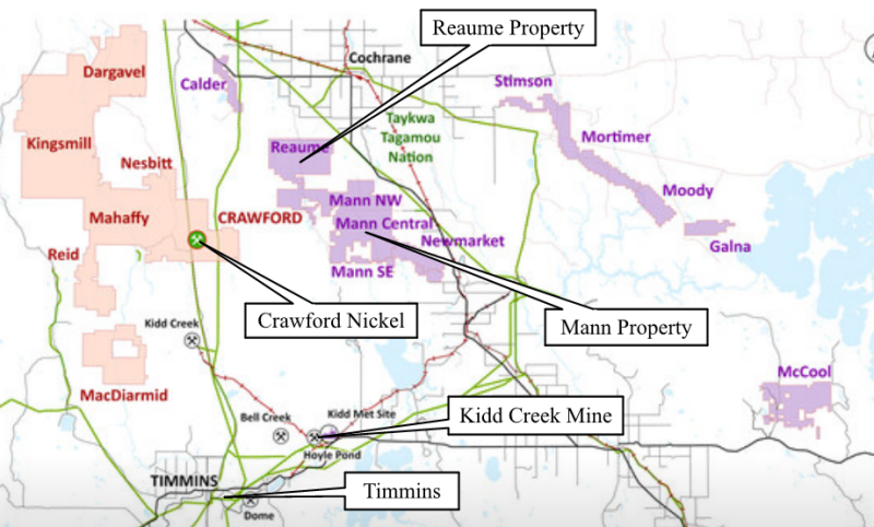
ExploreCo, the name of which will be announced in due course, will control 1,989 mining claims totaling approximately 42,000 hectares and will include nickel properties in Mann, Newmarket, and Reaume Townships as well as Calder, Galna, McCool, Moody, Mortimer, Stimson, and other properties currently held by Canada Nickel (see Figure 1, ExploreCo properties shown in purple).


Click Image To View Full Size

Figure 1 - Regional Map of ExploreCo Properties (purple)

Under the Binding Letter of Intent, the first $5 million of funding for ExploreCo will be provided from existing funds by Canada Nickel, after which costs will be funded by pro rata ownership basis, which will initially be 80% Canada Nickel and 20% Noble. Canada Nickel and Noble will continue to maintain their existing royalty rights on the ExploreCo claims, as will previous claim owners who had vended claims to Noble. (see NR July 8, 2024)

Mann Property

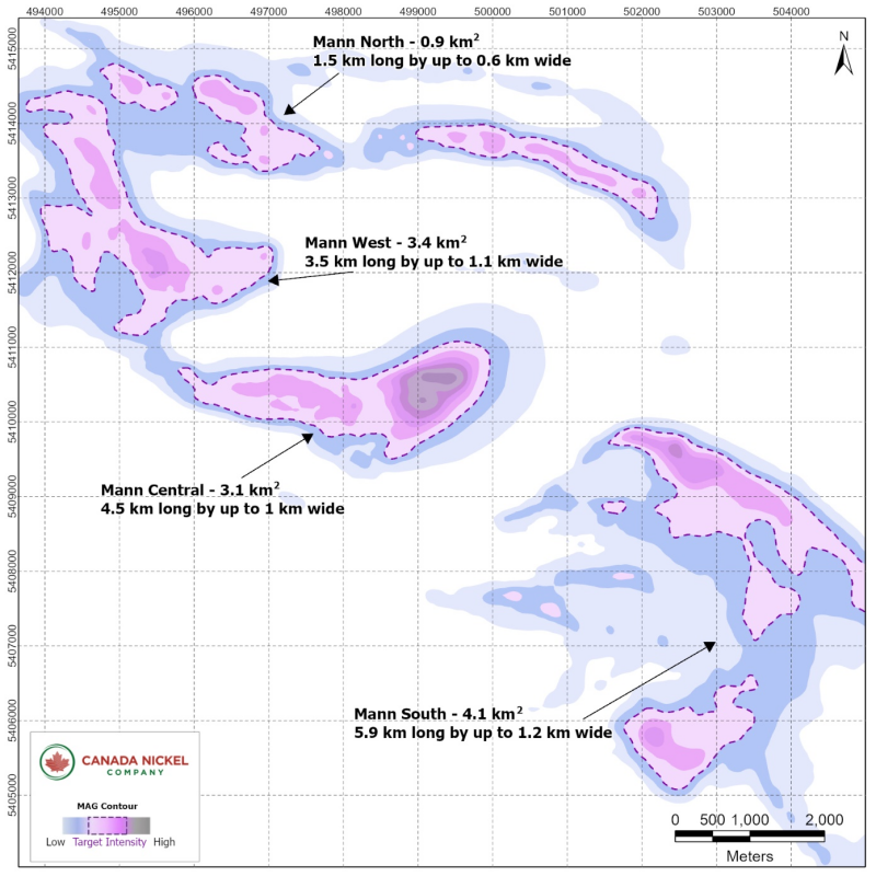
The Mann property is located 22 kilometres east of Crawford between Timmins and Cochrane. The Company has completed a drill program in three of the four identified areas within the property, Mann North, Mann West (together formerly Mann Northwest), and Central. (Figure 2). Exploration at Mann South is currently underway. Canada Nickel currently owns 80% of the Mann Property after successfully completing an earlier earn-in agreement with Noble Mineral Exploration. This property is part of the creation of an 'ExploreCo' subsidiary with Noble Mineral Exploration (see press release July 8, 2024) with Noble owning the other 20%.

Figure 2 – Mann Property


Click Image To View Full Size

Mann West

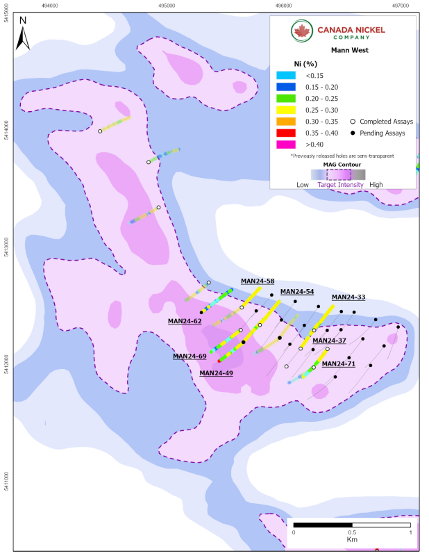
Mann West is approximately 3.5 kilometres long by up to 1.1 kilometres wide (covering 3.4 square kilometres). The drill program has focused on the southern half of the target with drilling completed over a strike length of 1.7 kilometres and a width of at least 600 metres. All drillholes intersected long sections of well-serpentinized peridotite and minor dunite with disseminated and visible nickel sulphide mineralization consisting primarily of pentlandite and heazlewoodite. The Company has drilled 40 holes to date at Mann West (Figure 3), 31 of which were drilled during the 2024 program. With this drilling, the Company has completed the first phase of exploration that is required for an initial resource estimate expected by Q1 2025. Assays from nine holes are presented in this release, with the remaining holes at Mann West still pending.

Table 2 – Mann West drilling highlights.

Hole ID

From (m)

To (m)

Length (m)*

Ni %

Co %

Pd g/t

Pt g/t

Cr %

Fe %

S %

MANN WEST

MAN24-33

11.2

396.0

384.8

0.24

0.011

0.009

0.008

0.35

6.48

0.028

including

174.0

183.0

9.0

0.30

0.014

0.018

0.011

0.18

6.34

0.100

MAN24-37

8.7

180.0

171.3

0.26

0.011

0.005

0.006

0.15

6.04

0.037

and

236.4

402.0

165.6

0.26

0.012

0.008

0.007

0.24

6.26

0.071

including

267.0

273.0

6.0

0.37

0.013

0.004

0.005

0.30

7.73

0.100

and

361.5

369.0

7.5

0.38

0.013

0.078

0.043

0.18

6.35

0.162

MAN24-45

6.2

402.0

395.8

0.24

0.013

0.016

0.010

0.39

6.60

0.235

including

136.5

144.0

7.5

0.30

0.014

0.044

0.015

0.75

6.99

0.086

MAN24-49

5.4

198.2

192.8

0.19

0.013

0.029

0.017

0.41

7.44

0.081

and

221.6

402.0

180.4

0.21

0.011

0.003

0.006

0.42

6.69

0.033

MAN24-54

49.5

192.8

143.3

0.26

0.011

0.003

0.003

0.13

5.80

0.045

and

216.5

402.0

185.5

0.27

0.012

0.012

0.007

0.28

6.22

0.029

including

268.5

277.5

9.0

0.48

0.019

0.003

0.003

0.62

7.86

0.015

MAN24-58

21.0

351.0

330.0

0.26

0.013

0.015

0.007

0.24

6.51

0.076

including

193.5

204.5

11.0

0.35

0.015

0.023

0.009

0.44

6.86

0.110

and

307.5

321.0

13.5

0.36

0.016

0.040

0.018

0.19

7.17

0.130

MAN24-62

8.6

501.0

492.4

0.18

0.014

0.041

0.026

0.31

7.88

0.047

MAN24-69

7.2

229.5

222.3

0.19

0.013

0.022

0.015

0.38

7.35

0.054

and

264.0

491.0

227.0

0.19

0.013

0.004

0.005

0.41

7.35

0.023

MAN24-71

23.5

260.5

237.0

0.27

0.012

0.011

0.009

0.25

6.29

0.082

including

63.0

108.0

45.0

0.37

0.013

0.036

0.018

0.15

5.77

0.196

and

302.2

501.0

198.8

0.17

0.012

0.014

0.032

0.36

7.56

0.027

*True width undetermined. All lengths are drillhole lengths.

Figure 3 – Mann West


Click Image To View Full Size

Mann Central

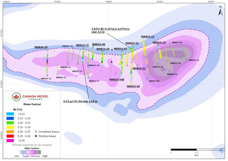
The outline of the ultramafic body at Mann Central is estimated by magnetics to be 4.5 kilometres long and between 0.5 to 1.0 kilometres wide (or 3.1 square kilometres). Drilling at this target was completed during the spring/summer of 2024 and now totals 32 drillholes and 11,853 metres. Mineralization is more consistent near the center of the target over an area of 1.9 kilometres by 600 metres (1.1 square kilometres). This release provides an update for 13 drillholes (Table 3), all of which intersected varying degrees of mineralized peridotite with minor pyroxenite dykes.

Mafic volcanics with abundant sulphide mineralization in the north contact were intersected in eight holes including MAN24-32 which yielded 3.3 metres of 1.03% nickel, 0.31% cobalt, and 0.57 % copper. Assays are still pending for 10 drillholes and the results from nine drillholes were previously released (see press release September 10, 2024).

Table 3 – Mann Central drilling highlights.

Hole ID

From (m)

To (m)

Length (m)*

Ni %

Co %

Pd g/t

Pt g/t

Cr %

Fe %

S %

MAN24-19

3.0

304.0

301.0

0.18

0.012

0.008

0.006

0.42

7.36

0.037

and

384.0

396.8

12.8

0.18

0.010

0.003

0.008

0.33

6.29

0.083

MAN24-22

9.0

552.0

543.0

0.24

0.012

0.005

0.006

0.17

5.90

0.057

Including

195.0

207.0

12.0

0.29

0.013

0.022

0.008

0.14

5.66

0.082

MAN24-26

12.0

55.5

43.0

0.25

0.011

0.003

0.008

0.18

5.85

0.101

and

100.5

399.0

298.5

0.23

0.011

0.004

0.003

0.16

6.22

0.052

MAN24-32

90.0

402.0

312.0

0.21

0.015

0.004

0.004

0.27

6.42

0.121

including

96.0

99.3

3.3

1.03

0.308

0.026

0.013

0.14

19.78

4.840

MAN24-34

75.0

259.0

184.0

0.22

0.011

0.008

0.008

0.31

6.79

0.044

and

297.0

402.0

105.0

0.24

0.011

0.007

0.008

0.22

5.97

0.080

MAN24-35

25.2

144.3

119.1

0.22

0.012

0.003

0.004

0.24

6.74

0.051

and

161.0

387.0

226.0

0.18

0.013

0.005

0.006

0.40

7.39

0.030

MAN24-39

97.5

171.0

73.5

0.19

0.011

0.007

0.007

0.45

7.28

0.049

MAN24-40

103.3

153.0

49.7

0.24

0.012

0.004

0.004

0.26

6.10

0.071

and

141.0

396.0

255.0

0.21

0.012

0.005

0.005

0.41

7.05

0.031

MAN24-43

76.7

182.4

105.7

0.22

0.012

0.005

0.006

0.22

6.37

0.114

and

205.4

402.0

196.6

0.23

0.012

0.003

0.005

0.38

6.56

0.033

MAN24-44

43.0

186.7

143.7

0.21

0.011

0.004

0.004

0.30

6.65

0.029

and

195.0

402.0

207.0

0.19

0.013

0.005

0.007

0.415

7.176

0.030

MAN24-52

11.4

46.7

35.3

0.31

0.037

0.003

0.006

0.169

5.794

0.176

and

73.0

400.0

327.0

0.20

0.013

0.004

0.005

0.390

6.779

0.028

MAN24-56B

45.0

402.0

357.0

0.20

0.013

0.003

0.005

0.411

7.126

0.022

MAN24-60

31.9

241.2

209.3

0.20

0.013

0.007

0.007

0.369

6.920

0.060

and

277.5

310.9

33.4

0.26

0.015

0.003

0.004

0.055

8.981

0.057

*True width undetermined. All lengths are drillhole lengths.

Figure 4 – Mann Central


Click Image To View Full Size

Mann North

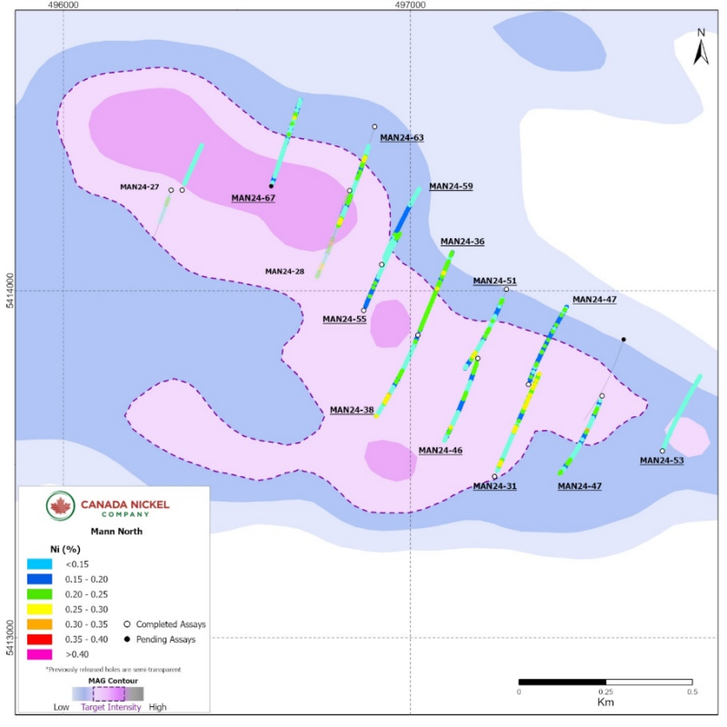
The Mann North target is approximately 1.5 kilometres long by 600 metres wide (0.9 square kilometres) (Figure 4). Drilling was completed during the summer of 2024 and consisted of a preliminary exploratory phase of 16 drillholes totaling 6,315 metres. The majority of these holes intersected long sections of peridotite, with minor dunite (Table 4) with nickel grades in the peridotite consistent with Crawford. The peridotites, however, have anomalous values of platinum (Pt) and palladium (Pd) over significant intervals, as seen on Table 5. Hole MAN24-31, for example, intersected 12.7 metres of 0.58 g/t Pt+Pd and MAN24-50 intersected 16.7 metres of 0.50 g/t Pt+Pd.

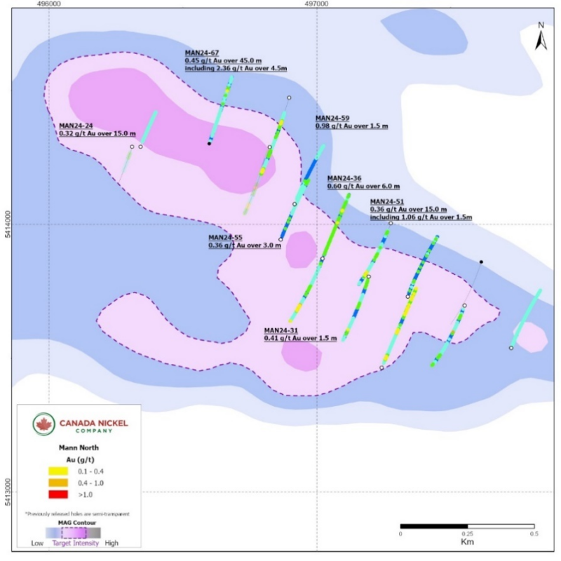
In addition to the anomalous Pt and Pd, the ultramafic units at Mann also have higher values for gold, especially near certain contacts. The intersections can be high grade and narrow such as in MAN23-12 which intersected 4.93 g/t gold over 1.5 metres or can be thicker and lower grade such as in MAN24-67 which intersected 0.45 g/t gold over 45.0 metres. Nine of 15 of the drillholes at Mann North assayed to date include gold intersections of 0.4 g/t gold or higher. Significant intersections are summarized in Table 6.

Assays are pending for three remaining holes.

Table 4 – Mann North drilling highlights

Hole ID

From (m)

To (m)

Length (m)*

Ni %

Co %

Pd g/t

Pt g/t

Cr %

Fe %

S %

MAN24-24

39.0

109.5

70.5

0.15

0.010

0.004

0.003

0.43

6.77

0.061

MAN24-31

28.4

519.0

490.6

0.18

0.012

0.013

0.022

0.38

6.88

0.061

including

57.0

72.0

15.0

0.30

0.014

0.044

0.024

0.28

6.47

0.280

MAN24-36

21.0

408.0

387.0

0.21

0.012

0.012

0.010

0.50

6.93

0.063

MAN24-46

18.8

312.5

293.7

0.17

0.012

0.005

0.007

0.40

7.54

0.028

and

327.9

399.0

71.1

0.17

0.014

0.012

0.008

0.39

8.25

0.057

MAN24-47

18.0

402.0

384

0.18

0.012

0.006

0.008

0.48

7.36

0.035

MAN24-50

21.5

280.6

259.1

0.15

0.012

0.004

0.005

0.45

7.54

0.024

and

313.5

390.0

76.5

0.18

0.013

0.010

0.011

0.41

7.29

0.051

MAN24-51

45.0

171.0

126

0.16

0.013

0.008

0.010

0.44

7.76

0.030

and

196.0

402.0

206

0.16

0.012

0.005

0.005

0.34

7.25

0.032

MAN24-53

15.0

402.0

387

0.11

0.012

0.007

0.010

0.33

8.07

0.032

MAN24-55

17.4

177.8

160.4

0.18

0.013

0.005

0.005

0.53

7.56

0.046

and

352.5

402.0

49.5

0.19

0.012

0.007

0.017

0.36

6.67

0.039

MAN24-59

31.5

402.0

370.5

0.15

0.012

0.010

0.011

0.38

7.19

0.044

MAN24-63

132.5

267.0

134.5

0.20

0.012

0.019

0.016

0.38

7.34

0.072

including

142.5

156.0

13.5

0.34

0.012

0.060

0.031

0.14

7.20

0.020

and

311.2

462.0

150.8

0.18

0.012

0.005

0.006

0.43

7.20

0.024

MAN24-67

15.6

420.0

404.4

0.15

0.012

0.025

0.021

0.36

7.72

0.039

including

327.0

348.0

21.0

0.23

0.013

0.081

0.043

0.55

7.79

0.141

Table 5 – Mann Properties PGM Highlights

Hole ID

From

(m)

To

(m)

Length

(m)

Pt+Pd

(g/t)

Pd

g/t)

Pt

(g/t)

Ni

(%)

Co

(%)

Cr

(%)

Fe

(%)

S

(%)

MAN24-49

201.0

219.0

18.0

0.51

0.30

0.21

0.04

0.007

0.37

4.58

0.021

MAN24-62

309

327

18.0

0.44

0.31

0.13

0.18

0.015

0.49

8.11

0.054

MAN24-35

390.0

402.0

12.0

0.33

0.11

0.22

0.06

0.011

0.48

7.49

0.014

MAN24-60

242.1

265.5

23.4

0.43

0.25

0.18

0.03

0.007

0.36

5.01

0.014

and

345.0

360.0

15.0

0.42

0.26

0.16

0.03

0.007

0.34

5.41

0.015

MAN24-69

238.0

255.0

17.0

0.45

0.26

0.19

0.04

0.007

0.39

4.76

0.013

MAN24-31

118.5

131.2

12.7

0.58

0.22

0.36

0.03

0.007

0.28

4.55

0.012

MAN24-38

125.0

138.0

13.0

0.32

0.21

0.11

0.02

0.007

0.28

6.79

0.024

and

285.0

292.6

7.6

0.47

0.21

0.26

0.05

0.011

0.29

6.21

0.013

and

382.5

396.2

13.7

0.39

0.18

0.21

0.05

0.012

0.36

5.64

0.018

MAN24-46

312.5

327.9

15.4

0.46

0.24

0.22

0.04

0.008

0.37

5.33

0.008

MAN24-50

280.6

297.3

16.7

0.50

0.33

0.17

0.03

0.007

0.38

5.07

0.011

MAN24-51

171.0

186.0

15.0

0.31

0.20

0.12

0.02

0.007

0.27

6.74

0.042

MAN24-55

288.0

337.0

49.0

0.33

0.17

0.17

0.02

0.007

0.25

6.33

0.038

MAN24-63

292.5

303.0

10.5

0.33

0.21

0.12

0.02

0.007

0.27

6.97

0.019

Figure 5 – Mann North


Click Image To View Full Size

Figure 6 – Mann North Gold Highlights


Click Image To View Full Size

Table 6 – Mann Properties Gold Highlights

Hole ID

From

(m)

To

(m)

Length

(m)

Au

(g/t)

MAN24-19

382.5

384.0

1.5

0.40

MAN24-24

52.5

67.5

15.0

0.32

MAN24-31

57.0

58.5

1.5

0.41

MAN24-36

348.0

354.0

6.0

0.60

including

348.0

349.5

1.5

1.58

MAN24-51

289.5

304.5

15.0

0.36

Including

300.0

301.5

1.5

1.06

MAN24-55

396.0

399.0

3.0

0.36

MAN24-59

139.5

141.0

1.5

0.51

and

274.5

276.0

1.5

0.98

MAN24-67

115.5

160.5

45.0

0.45

including

118.5

121.5

3.0

1.15

and

147.0

151.5

4.5

2.36

Reaume

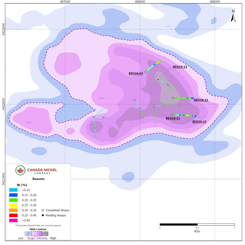
The Reaume property is located 20 kilometres northeast of Crawford, 15 kilometres southwest of Cochrane, and 55 kilometres northeast of Timmins. The property will form part of the ExploreCo subsidiary assets with Noble on an 80%-20% (Canada Nickel-Noble) ownership basis. Prior drill campaigns in 2022 had seasonal access constraints, however, in June 2024, the Company resumed exploration and intersected a mineralized portion of the ultramafic body consisting of moderate to strongly serpentinized peridotite containing spotty, coarse-grained awaruite mineralization in hole REU24-12 (Figure 7). This release contains the results of three drillholes at Reaume with assay results pending on two remaining holes.

Table 7– Reaume drilling highlights.

Hole ID

From (m)

To (m)

Length (m)*

Ni %

Co %

Pd g/t

Pt g/t

Cr %

Fe %

S %

REU24-11

36.0

501.0

465

0.19

0.012

0.004

0.005

0.623

7.403

0.020

REU24-12

40.3

561.0

520.7

0.19

0.013

0.003

0.006

0.588

7.375

0.026

Including

330.0

375.0

45

0.24

0.012

0.004

0.005

0.262

6.818

0.017

REU24-14

18.0

40.5

22.5

0.23

0.015

0.005

0.003

0.403

7.743

0.047

and

86.3

119.0

32.7

0.03

0.007

0.189

0.159

0.313

6.063

0.015

and

147.0

402.0

255

0.18

0.013

0.009

0.013

0.543

7.880

0.037

including

303.0

307.5

4.5

0.44

0.018

0.067

0.047

0.680

8.723

0.130

*True width undetermined. All lengths are drillhole lengths.

Table 8 Reaume PGM Highlights

Hole ID

From

(m)

To

(m)

Length

(m)

Pt+Pd

(g/t)

Pd

g/t)

Pt

(g/t)

Ni

(%)

Co

(%)

Cr

(%)

Fe

(%)

S

(%)

REU24-14

86.3

119.0

32.7

0.35

0.19

0.16

0.025

0.007

0.31

6.06

0.015

including

100.5

105.0

4.5

0.67

0.43

0.24

0.022

0.006

0.33

5.56

0.012

Figure 7 – Reaume


Click Image To View Full Size

Table 9: Drillhole Orientation

Hole ID

Easting (mE)

Northing (mN)

Azimuth (⁰)

Dip (⁰)

Length (m)

REID

REI24-41

457554

5404310

0

-60

706

REI24-43

457350

5404200

70

-60

696

REI24-45

457859

5403898

90

-60

668

REI24-46

456306

5404370

180

-50

702

REI24-47

457765

5404100

90

-60

702

REI24-48

456860

5404060

180

-55

702

REI24-50

457817

5404256

90

-60

600

REI24-52

457350

5404200

180

-60

759

MANN WEST

MAN24-33

496260

5412289

35

-50

396

MAN24-37

496144

5412134

35

-50

402

MAN24-45

495656

5412189

40

-50

402

MAN24-49

495656

5412189

230

-50

402

MAN24-54

495796

5412336

40

-50

402

MAN24-58

495641

5412486

40

-65

351

MAN24 - 62

495296

5412441

50

-50

501

MANN CENTRAL

MAN24-19

496800

5410400

0

-50

397

MAN24-22

498724

5410530

350

-50

552

MAN24-26

498360

5410370

0

-50

399

MAN24-32

498466

5410751

180

-50

402

MAN24-34

498970

5410764

165

-50

402

MAN24-35

497509

5410702

180

-50

402

MAN24-39

498466

5410751

215

-55

171

MAN24-40

497698

5410729

180

-50

396

MAN24-43

498265

5410644

180

-50

402

MAN24-44

497880

5410638

180

-50

402

MAN24-52

498450

5410430

180

-50

400

MAN24-56B

498260

5410430

180

-50

402

MAN24-60

498445

5410230

180

-50

360

MANN NORTH

MAN24-24

496342

5414290

20

-50

237

MAN24-31

497243

5413464

20

-50

519

MAN24-36

497022

5413872

20

-50

408

MAN24-46

497195

5413805

200

-50

402

MAN24-47

497340

5413730

20

-50

402

MAN24-50

497552

5413697

200

-50

402

MAN24-51

497277

5414004

200

-50

402

MAN24-53

497727

5413538

20

-50

402

MAN24-55

496866

5413943

20

-50

402

MAN24-59

496917

5414076

20

-50

402

MAN24-67

496599

5414301

20

-50

420

REAUME

REU24-11

488435

5422086

90

-50

501

REU24-12

488424

5421854

90

-50

561

REU24-14

488077

5422433

45

-50

402

Quality Assurance and Control, Drilling and Assaying

Edwin Escarraga, MSc, P.Geo., a "qualified person" as defined by National Instrument 43-101, is responsible for the on-going drilling and sampling program, including quality assurance (QA) and quality control (QC). The core is collected from the drill in sealed core trays and transported to the core logging facility. The core is marked and sampled at 1.5 metre lengths and cut with a diamond blade saw. One set of samples is transported in secured bags directly from the Canada Nickel core shack to Actlabs Timmins, while a second set of samples is securely shipped to SGS Lakefield for preparation, with analysis performed at SGS Burnaby or SGS Callao (Peru). All are ISO/IEC 17025 accredited labs. Analysis for precious metals (gold, platinum and palladium) are completed by Fire Assay while analysis for nickel, cobalt, sulphur and other elements are performed using a peroxide fusion and ICP-OES analysis. Certified standards and blanks are inserted at a rate of 3 QA/QC samples per 20 core samples making a batch of 60 samples that are submitted for analysis.

Qualified Person and Data Verification

Stephen J. Balch P.Geo. (ON), VP Exploration of Canada Nickel and a "qualified person" as such term is defined by National Instrument 43-101, has verified the data disclosed in this news release, and has otherwise reviewed and approved the technical information in this news release on behalf of Canada Nickel Company Inc .

Wayne Holmstead P.Geo (ON), a "qualified person" as defined by National Instrument 43-101, has reviewed the data disclosed in this news release, and has otherwise reviewed and approved the technical information in this news release on behalf of Noble.

About Noble Mineral Exploration Inc.:

Noble Mineral Exploration Inc. is a Canadian-based junior exploration company which, in addition to its shareholdings in Canada Nickel Company Inc., Homeland Nickel Inc., Go Metals Corp. and Lode Gold Resources Inc . , and its interest in the Holdsworth gold exploration property in the area of Wawa, Ontario, will continue to hold ~25,000 hectares of mineral rights in the Timmins-Cochrane areas of Northern Ontario known as Project 81, as well as an additional 20% interest in ~11,000 hectares in the Timmins area and ~175 hectares of mining claims in Central Newfoundland.  Project 81 hosts diversified drill-ready gold, nickel-cobalt and base metal exploration targets at various stages of exploration.  It will also hold its ~14,600 hectares in the Nagagami Carbonatite Complex and its ~4,600 hectares in the Boulder Project both near Hearst, Ontario, as well as ~3,700 hectares in the Buckingham Graphite Property, ~10,152 hectares in the Havre St Pierre Nickel, Copper, PGM property, and ~482 hectares in the Cere-Villebon Nickel, Copper, PGM property, all of which are in the province of Quebec.  More detailed information is available on the website at:

www.noblemineralexploration.com   .

Noble's common shares trade on the TSX Venture Exchange under the symbol "NOB".

Cautionary Statement:

Neither TSX Venture Exchange nor its Regulation Services Provider (as that term is defined in the policies of the TSX Venture Exchange) accepts responsibility for the adequacy or accuracy of this release. No stock exchange, securities commission or other regulatory authority has approved or disapproved the information contained herein.

The foregoing information may contain forward-looking statements relating to the future performance of Noble Mineral Exploration Inc. Forward-looking statements, specifically those concerning future performance, are subject to certain risks and uncertainties, and actual results may differ materially from the Company's plans and expectations. These plans, expectations, risks and uncertainties are detailed herein and from time to time in the filings made by the Company with the TSX Venture Exchange and securities regulators.  Noble Mineral Exploration Inc. does not assume any obligation to update or revise its forward-looking statements, whether as a result of new information, future events or otherwise.

Contacts:

H. Vance White, President

Phone:        416-214-2250

Fax:        416-367-1954

Email: info@noblemineralexploration.com

Investor Relations: ir@noblemineralexploration.com

Copyright (c) 2024 TheNewswire - All rights reserved.

News Provided by TheNewsWire via QuoteMedia

NOB:CA
Noble Mineral

Noble Mineral Investor Kit

  • Corporate info
  • Insights
  • Growth strategies
  • Upcoming projects

GET YOUR FREE INVESTOR KIT

The Conversation (0)
Noble Mineral Exploration

Noble Mineral


Keep reading...Show less
Noble Minerals More Than Triples the Size of the Cere Villebon Copper, Nickel, Cobalt, Platinum Group Property, Quebec

Noble Minerals More Than Triples the Size of the Cere Villebon Copper, Nickel, Cobalt, Platinum Group Property, Quebec

(TheNewswire)

Noble Mineral Exploration Inc.

Toronto, Ontario TheNewswire - January 27, 2025 Noble Mineral Exploration Inc. ( "Noble" or the "Company" ) (TSX-V:NOB, FRANKFURT: NB7, OTCQB:NLPXF) is pleased to report acquisition of additional claims on the wholly owned Cere Villebon Property located southeast of Val d'Or, Quebec.  The claims were acquired by map staking and the new property area is now approximately 1,573 Hectares.  The new area staked is currently being evaluated for the potential to host similar mineralization to that found in 2023.

News Provided by TheNewsWire via QuoteMedia

Keep reading...Show less
Noble Minerals Acquires a Property with Significant Uranium, Rare Earth, Phosphorus and Silver Mineralization in Northern Quebec

Noble Minerals Acquires a Property with Significant Uranium, Rare Earth, Phosphorus and Silver Mineralization in Northern Quebec

(TheNewswire)

Noble Mineral Exploration Inc.

Highlights

News Provided by TheNewsWire via QuoteMedia

Keep reading...Show less
Noble and Canada Nickel Announce Signing of Definitive Agreement for Creation of ExploreCo

Noble and Canada Nickel Announce Signing of Definitive Agreement for Creation of ExploreCo

(TheNewswire)

Noble Mineral Exploration Inc.

Noble Mineral Exploration Inc. (" Noble " or the " Company ") (TSXV: NOB) (OTCQB: NLPXF) is pleased to announce that it has signed a Definitive Implementation Agreement with  Canada Nickel Company Inc. ("Canada Nickel") whereby Noble and Canada Nickel will spin-out certain mining claims (the "Properties") into a new company to consolidate their interests in large tonnage, low grade nickel projects northeast of Timmins, Ontario

News Provided by TheNewsWire via QuoteMedia

Keep reading...Show less
Noble Minerals Announces Update to Drilling Results from Noble Minerals-Canada Nickel Joint Venture on Mann Twp

Noble Minerals Announces Update to Drilling Results from Noble Minerals-Canada Nickel Joint Venture on Mann Twp

(TheNewswire)

Noble Mineral Exploration Inc.

Highlights

News Provided by TheNewsWire via QuoteMedia

Keep reading...Show less
Noble Completes Phase 1 Drilling on Boulder Project near Hearst, Ontario:

Noble Completes Phase 1 Drilling on Boulder Project near Hearst, Ontario:

(TheNewswire)

Noble Mineral Exploration Inc.

Provides Update on Timmins and Wawa Area, Gold Projects

News Provided by TheNewsWire via QuoteMedia

Keep reading...Show less
Cygnus Metals Limited Clarification Announcement

Cygnus Metals Limited Clarification Announcement

-

Cygnus Metals Limited (ASX: CY5; TSXV: CYG) ("Cygnus" or the "Company") refers to its announcement titled "Cygnus increases highly prospective, under-explored ground position by 50%" released to ASX on 9 January 2025 ("First Announcement") and its announcement titled "Cygnus' first drill hole returns up to 9.1% Cu outside Resource" released to ASX on 23 January 2025 ("Second Announcement").

Clarifications regarding First Announcement

In discussions with the Company subsequent to the release of the First Announcement, the Australian Securities Exchange ("ASX") has requested the below:

  • Clarification regarding the assumptions used in the copper metal equivalents calculations provided by Cygnus on the NI 43-101 compliant Foreign Mineral Resource Estimate for the Chibougamau Project in the First Announcement; and
  • Further information regarding metallurgical test work completed to support the Company's metallurgical recovery assumptions provided in this clarification announcement.

The Company wishes to provide further information on these assumptions and the metallurgical test work previously completed by Doré Copper Mining Corp ("Doré"), but emphasises that the clarification does not affect the Foreign Mineral Resource Estimate or the Copper Equivalent ("CuEq") figures as set out in Appendix A of the First Announcement and as first disclosed by the Company on 15 October 2024.

Note 6 of Appendix A on page 6 of the First Announcement is replaced with the following ("First Clarification"):

"Metal equivalents for the foreign estimate have been calculated at a copper price of US$8,750/t, gold price of US$2,350/oz. Copper equivalent was calculated based on the formula CuEq(%) = Cu(%) + (Au(g/t) x 0.77258). Metallurgical recovery factors have been applied to the copper equivalents calculation, with copper metallurgical recovery assumed at 95% and gold metallurgical recovery assumed at 85% based upon historical production at the Chibougamau Processing Facility and more recent metallurgical test work. It is the Company's view that all elements in the copper equivalent calculations have a reasonable potential to be recovered and sold."

The Company confirms that the Foreign Mineral Resource Estimate and metal equivalents calculation do not contain any other metals, including silver. In fact, the inclusion of silver represents a further opportunity for the Company and will be reviewed in future work.

Other than the First Clarification above, there are no changes to the First Announcement.

In support of the First Clarification, attached to this announcement are the results of metallurgical test work previously completed by Doré.

Clarifications regarding Second Announcement

In discussions with the Company subsequent to the release of the Second Announcement, the ASX has requested that the Company provide further information regarding two of the three electromagnetic ("EM") plates referred to in Figures 1 and 2 of the Second Announcement in accordance with ASX Listing Rules 5.6 and 5.7.

The Company wishes to note that the two additional untested EM plates to the south of the new EM plate referred to in the Second Announcement were identified from geophysics programs conducted by previous owners of the Chibougamau Project and provides the additional information set out in the Appendix to this clarification announcement ("Second Clarification").

A fixed loop EM ("FLEM") survey was conducted in 2007 by Crone Geophysics for Novawest Resources. Results from this survey, which Southern Geoscience Consultants ("SGC") has reprocessed for Cygnus, highlighted a conductor to the south of the Corner Bay deposit. A downhole EM ("DHEM") survey was conducted by Doré in 2021 on drillhole CB-21-93. The survey, which SGC has reprocessed for Cygnus, highlighted a further conductor to the south of the Corner Bay deposit.

Other than the Second Clarification, there are no changes to the Second Announcement.

This announcement has been authorised for release by the Board of Directors of Cygnus.

David Southam
Managing Director
T: +61 8 6118 1627
E: info@cygnusmetals.com
Ernest Mast
President & Managing Director
T: +1 647 921 0501
E: info@cygnusmetals.com
Media:
Paul Armstrong
Read Corporate
+61 8 9388 1474


About Cygnus Metals

Cygnus Metals Limited (ASX: CY5, TSXV: CYG) is a diversified critical minerals exploration and development company with projects in Quebec, Canada and Western Australia. The Company is dedicated to advancing its Chibougamau Copper-Gold Project in Quebec with an aggressive exploration program to drive resource growth and develop a hub-and-spoke operation model with its centralised processing facility. In addition, Cygnus has quality lithium assets with significant exploration upside in the world-class James Bay district in Quebec, and REE and base metal projects in Western Australia. The Cygnus team has a proven track record of turning exploration success into production enterprises and creating shareholder value.

Qualified Persons and Compliance Statements

The scientific and technical information relating to metal equivalents in this news release has been reviewed and approved by Ms Laurence Huss, the Quebec In-Country Manager of Cygnus, a "qualified person" as defined in National Instrument 43-101 – Standards of Disclosure for Mineral Projects. The Company first announced the foreign estimate of mineralisation for the Chibougamau Project on 15 October 2024. The Company confirms that the supporting information included in the announcement of 15 October 2024 continues to apply other than in respect of the Clarification, and (notwithstanding the Clarification) has not materially changed.

Cygnus confirms that (notwithstanding the Clarification) it is not aware of any new information or data that materially affects the information included in the original announcement and that all material assumptions and technical parameters underpinning the estimates in the original announcement continue to apply and have not materially changed. Cygnus confirms that it is not in possession of any new information or data that materially impacts on the reliability of the estimates or Cygnus' ability to verify the foreign estimates as mineral resources in accordance with the JORC Code. The Company confirms that the form and context in which the Competent Persons' findings are presented have not been materially modified from the original market announcement.

The scientific and technical information relating to exploration results in this news release has been reviewed and approved by Mr Louis Beaupre, the Quebec Exploration Manager of Cygnus, a "qualified person" as defined in National Instrument 43-101 – Standards of Disclosure for Mineral Projects. The Exploration Results disclosed in this announcement are based on and fairly represent information and supporting documentation compiled by Mr Beaupre. Mr Beaupre holds options in Cygnus. Mr Beaupre is a member of the Ordre des ingenieurs du Quebec (P Eng), a Registered Overseas Professional Organisation as defined in the ASX Listing Rules, and has sufficient experience which is relevant to the style of mineralisation and type of deposits under consideration and to the activity which has been undertaken to qualify as a Competent Person as defined in the 2012 Edition of the "Australasian Code for Reporting of Exploration Results, Mineral Resources and Ore Reserves". Mr Beaupre consents to the inclusion in this release of the matters based on the information in the form and context in which they appear.

Neither TSX Venture Exchange nor its Regulation Services Provider (as that term is defined in policies of the TSX Venture Exchange) accepts responsibility for the adequacy or accuracy of this release.

Appendix – Second Clarification

Section 1 (Sampling Techniques and Data) and Section 2 (Reporting of Exploration Results) of Appendix C (2012 JORC Table 1) of the Second Announcement are deleted and replaced as follows:

Section 1 Sampling Techniques and Data

Criteria JORC Code explanation Commentary
Sampling techniques


Nature and quality of sampling (eg cut channels, random chips, or specific specialised industry standard measurement tools appropriate to the minerals under investigation, such as down hole gamma sondes, or handheld XRF instruments, etc). These examples should not be taken as limiting the broad meaning of sampling.
  • All current drilling conducted at the Chibougamau Project was completed under the supervision of a registered professional geologist as a Qualified Person (QP) who is responsible and accountable for the planning, execution, and supervision of all exploration activity as well as the implementation of quality assurance programs and reporting.
  • All drilling reported is NQ2 (47.8 mm diameter)
  • DHEM surveys have been completed on surface drillholes
  • Historic FLEM surveys were acquired from surface
  • Historic FLEM stations were planned along survey lines perpendicular to geological strike
Include reference to measures taken to ensure sample representivity and the appropriate calibration of any measurement tools or systems used.
  • All sample collection, core logging, and specific gravity determinations were completed by Cygnus Metals under the supervision of a professionally qualified registered geologist.
  • NQ core was marked for splitting during logging and is sawn using a diamond core saw with a mounted jig to assure the core is cut lengthwise into equal halves.
  • Half of the cut core is placed in clean individual plastic bags with the appropriate sample tag.
  • QA/QC is done in house by Cygnus Metals geologists with oversight from the Senior Geologist. The check samples (blanks and standards – 4% of total samples with another 2% of core duplicates taken on half split core) that were inserted into the sample batches are verified against their certified values and are deemed a pass if they are within 3 standard deviations of the certified value. The duplicates are evaluated against each other to determine mineralization distribution (nugget). If there are large discrepancies in the check samples, then the entire batch is requested to be re-assayed. The samples are then placed in bags for shipment to the offsite laboratory's facility.
  • The remaining half of the core is retained and incorporated into Cygnus's secure, core library located on the property
  • No samples were taken for the electromagnetic survey work.
Aspects of the determination of mineralisation that are Material to the Public Report.

In cases where ‘industry standard' work has been done this would be relatively simple (eg ‘reverse circulation drilling was used to obtain 1 m samples from which 3 kg was pulverised to produce a 30 g charge for fire assay'). In other cases more explanation may be required, such as where there is coarse gold that has inherent sampling problems. Unusual commodities or mineralisation types (eg submarine nodules) may warrant disclosure of detailed information.

  • Industry standard sampling practices were used with sample lengths ranging from 0.3 m to 1.0 m and respected geological contacts. Sample tags were placed at the beginning of each sample interval and the tag numbers were recorded in an MS Excel database.
  • Sampling practice is considered to be appropriate to the geology and style of mineralisation
Drilling techniques Drill type (eg core, reverse circulation, open-hole hammer, rotary air blast, auger, Bangka, sonic, etc) and details (eg core diameter, triple or standard tube, depth of diamond tails, face-sampling bit or other type, whether core is oriented and if so, by what method, etc).
  • Diamond core was drilled using surface diamond rigs with industry recognised contractors Miikan Drilling. Miikan is a joint venture between Chibougamau Diamond Drilling Ltd., the First Nations community of Ouje-Bougoumou and the First Nations community of Mistissini both located in the Eeyou Istchee territory.
  • Drilling was conducted using NQ core size
  • Directional surveys have been taken at 50m intervals
Drill sample recovery Method of recording and assessing core and chip sample recoveries and results assessed.

Measures taken to maximise sample recovery and ensure representative nature of the samples.

Whether a relationship exists between sample recovery and grade and whether sample bias may have occurred due to preferential loss/gain of fine/coarse material.

  • Diamond core recovery was measured for each run and calculated as a percentage of the drilled interval.
  • Overall, the core recoveries are excellent in the Chibougamau area
  • No drilling was undertaken for the electromagnetic survey work.
Logging


Whether core and chip samples have been geologically and geotechnically logged to a level of detail to support appropriate Mineral Resource estimation, mining studies and metallurgical studies.
  • All core was geologically and geotechnically logged. Lithology, veining, alteration and mineralisation are recorded in multiple tables of the drillhole database
  • No logging was undertaken for the electromagnetic survey work.
Whether logging is qualitative or quantitative in nature. Core (or costean, channel, etc) photography.
  • Geological logging of core is qualitative and descriptive in nature.
The total length and percentage of the relevant intersections logged.
  • 100% of the core has been logged
Sub-sampling techniques and sample preparation If core, whether cut or sawn and whether quarter, half or all core taken.

If non-core, whether riffled, tube sampled, rotary split, etc and whether sampled wet or dry.

For all sample types, the nature, quality and appropriateness of the sample preparation technique.

Quality control procedures adopted for all sub-sampling stages to maximise representivity of samples.

Measures taken to ensure that the sampling is representative of the in-situ material collected, including for instance results for field duplicate/second-half sampling.

Whether sample sizes are appropriate to the grain size of the material being sampled.

  • The NQ2 diameter the core was sawn in half following a sample cutting line determined by geologists during logging and submitted for analysis on nominal 1m intervals or defined by geological boundaries determined by the logging geologist
  • Each core sample is assigned a tag with a unique identifying number. Sample lengths are typically one metre but can be depending on zone mineralogy and boundaries.
  • This sampling technique is industry standard and deemed appropriate.
  • No subsampling was undertaken for the electromagnetic survey work.
Quality of assay data and laboratory tests


The nature, quality and appropriateness of the assaying and laboratory procedures used and whether the technique is considered partial or total.
  • Sample (NQ size half core) preparation and fire assay analysis were done at Bureau Veritas Commodities Canada Ltd ("BV") in Timmins, Ontario, and ICP-ES multi-elements analysis was done at BV in Vancouver, B.C.
  • Samples were weighed, dried, crushed to 70% passing 2 mm, split to 250 g, and pulverized to 85% passing 75 µm.
  • Samples are fire assayed for gold (Au) (30 g) and multi-acid digestion ICP-ES finish, for 23 elements (including key elements Ag, Cu, Mo).
  • Samples assaying >10.0 g/t Au are re-analysed with a gravimetric finish using a 30 g charge. Samples assaying >10% Cu are re-analysed with a sodium peroxide fusion with ICP-ES analysis using a 0.25 g charge.
For geophysical tools, spectrometers, handheld XRF instruments, etc, the parameters used in determining the analysis including instrument make and model, reading times, calibrations factors applied and their derivation, etc.
  • CY5 commissioned Southern Geoscience Consultants (SGC) of Perth to supervise and plan the recent DHEM surveys that were acquired by Géophysique TMC
  • SGC were also commissioned to reinterpret some DHEM collected by Géophysique TMC from 2021
  • Survey Details for DHEM
    • Survey Configuration: Downhole TEM (DHTEM)
    • TX Loop Size: 620 x 450m
    • Transmitter: Crone Geophysics Pulse Transmitter
    • Receiver: Crone Geophysics Pulse Receiver
    • Sensor: Crone Geophysics 3 component dB/dt induction coil
    • Component Directions: Axial (A), and cross-hole (U and V)
    • Station Spacing: 10m with 5m infill
    • TX Frequency: 5 Hz
    • Duty cycle: 50%
    • Current: 20 Amps
    • Powerline Frequency: 60 Hz
    • Base frequency: 50 msec
    • Stacks: 256 stacks per reading
  • CY5 also commissioned SGC to reprocess the historic FLEM that was conducted in 2007 under the supervision of Crone Geophysics and Exploration Ltd
    • The equipment used on this project was a Crone Pulse EM Surface system. This includes a 4.8kW transmitter with a 240V voltage regulator powered by an 11 hp motor generator. The Crone Digital Receiver was used to collect the field data. The synchronization between the Transmitter and the Receiver was maintained by crystal clock synchronization for surface work
      • TX Loop Size: 900 x 800m
      • Ramp Time: 1.5ms
      • Current: 15 amps
      • Time Base: 16.66 msec
Nature of quality control procedures adopted (eg standards, blanks, duplicates, external laboratory checks) and whether acceptable levels of accuracy (i.e. lack of bias) and precision have been established.
  • Laboratory QC procedures involve the use of internal certified reference material as assay standards, along with blanks, duplicates and replicates
  • Geophysical data was recorded on a Crone Geophysics Pulse Receiver then emailed to SGC for analysis and verification
Verification of sampling and assaying


The verification of significant intersections by either independent or alternative company personnel.
  • Verification of sampling was made by Cygnus Metals and other professional consultant geologists
  • No sampling was undertaken for the electromagnetic survey work.
The use of twinned holes.
  • No hole is twinned
Documentation of primary data, data entry procedures, data verification, data storage (physical and electronic) protocols.
  • All logging data was completed, core marked up, logging and sampling data was entered directly into the database.
  • The logged data is stored on the site server directly.
Discuss any adjustment to assay data.
  • There was no adjustment to the assay data
Location of data points


Accuracy and quality of surveys used to locate drill holes (collar and down-hole surveys), trenches, mine workings and other locations used in Mineral Resource estimation.
  • The location of the drillholes and the aiming points for the orientation of the drillholes were indicated on the ground using identified stakes. The stakes marking the location of the drillholes were set up and located with a Garmin GPS model "GPSmap 62s" (4m accuracy)
  • Surveys are collected using a Reflex EZ-Shot® single-shot electronic instrument with readings collected at intervals of approximately every 30 m downhole plus a reading at the bottom of the hole
  • Surface geophysical measurement locations were determined using a hand-held GPS. The accuracy of this unit at most sample sites was +/- 3m to 5m
  • The DHEM station positions are estimated using a winch counter that measures to the nearest cm accuracy with gyro survey files to accurately locate the survey stations in space.
  • FLEM stations were planned perpendicular to geological strike, and all were surveyed with hand-held GPS
Specification of the grid system used.
  • The grid system used is UTM NAD83 (Zone 18)
Quality and adequacy of topographic control.
  • A Digital Terrane Model (DTM) has been used to accurately plot the vertical position of the holes
Data spacing and distribution


Data spacing for reporting of Exploration Results.
  • The drill spacing is considered appropriate for this type of exploration
  • DHEM is 10m stations with 5m and 1m infill and FLEM data is 100m station spacing
  • The station spacings are considered to be sufficient for sampling the anomalous response for detailed quantitative modelling
Whether the data spacing and distribution is sufficient to establish the degree of geological and grade continuity appropriate for the Mineral Resource and Ore Reserve estimation procedure(s) and classifications applied.

  • No resource estimation is made
Whether sample compositing has been applied.
  • No sample compositing has been applied
Orientation of data in relation to geological structure

Whether the orientation of sampling achieves unbiased sampling of possible structures and the extent to which this is known, considering the deposit type.
  • Drilling is orientated approximately at right angles to the currently interpreted strike of the known interpreted mineralisation. Reported intersections appear close to true width
  • FLEM stations were planned perpendicular to geological strike
  • DHEM surveys records 3D data and target orientation relative to the survey orientation is not deemed to be important in the modelling
If the relationship between the drilling orientation and the orientation of key mineralised structures is considered to have introduced a sampling bias, this should be assessed and reported if material.

  • No bias is considered to have been introduced by the existing sampling orientation
Sample security The measures taken to ensure sample security.
  • Core was placed in wooden core boxes close to the drill rig by the drilling contractor. The core was collected daily by the drilling contractor and delivered to the secure core logging facility. Access to the core logging facility is limited to Cygnus employees or designates
Audits or reviews The results of any audits or reviews of sampling techniques and data.
  • No audits have been undertaken, therefore information on audits or reviews is not yet available


Section 2 Reporting of Exploration Results

(Criteria listed in the preceding section also apply to this section.)

Criteria JORC Code Explanation Commentary
Mineral tenement and land tenure status

Type, reference name/number, location and ownership including agreements or material issues with third parties such as joint ventures, partnerships, overriding royalties, native title interests, historical sites, wilderness or national park and environmental settings.
  • The data reported within this announcement is from the Chibougamau Project. The Chibougamau project consists of 3 properties which includes:
    • Copper Rand (1 mining license, 19 mining concession and 147 exploration claims)
    • Corner Bay – Devlin (1 mining license, 111 exploration claims)
    • Joe Mann (2 mining concessions, 74 exploration claims)
  • Copper Rand and Corner Bay – Devlin are held 100% by CBAY minerals Inc, a wholly owned subsidiary of Dore Copper.
  • 767ha of the Joe Mann property is held by CBAY with the remaining 1965ha held under option agreement with Resources Jessie.
  • The properties collectively making up the Project are in good standing based on the Ministry of Energy and Natural Resources (Ministère de l'Énergie et des Ressources Naturelles) GESTIM claim management system of the Government of Québec.
The security of the tenure held at the time of reporting along with any known impediments to obtaining a licence to operate in the area.
  • All tenure is in good standing
Exploration done by other parties Acknowledgment and appraisal of exploration by other parties.
  • The Chibougamau Copper and Gold project comprising Corner Bay, Devlin, Cedar Bay and Joe Mann have seen an extensive exploration history dating back to the early 1900s. The PEA (as referred to in the Company's announcement of 15 October 2024) provides a detailed history of the exploration activities undertaken by previous explorers.
  • Corner Bay was first identified as a prospect in 1956
    • 1956 – 1972 eight drilling programs totalling 1,463 m and various geophysical and electromagnetic (EM) surveys
    • 1973 – 1981 Riocanex and Flanagan McAdam: ground geophysical surveys and 43 diamond drill holes
    • 1982 – 1984 Riocanex and Corner Bay Exploration: 38 drill holes and metallurgical test work
    • 1988 – 1991 Corner Bay Exploration: diamond drilling, geophysical surveys and geological characterisation with initial MRE
    • 1992 – 1994 SOQUEM optioned and acquired a 30% interest, and completed diamond drilling
    • 1994 Explorations Cache Inc and Ressources MSV Inc: diamond drilling
    • 2004 – 2006 GéoNova and MSV: 98 diamond drill holes and first Technical Report on the Corner Bay project reporting a MRE
    • 2007 – 2009 Campbell: diamond drilling and bulk sample
    • 2012 - 2019 CBAY / AmAuCu: diamond drilling and MRE
  • Devlin identified in 1972 by airborne survey flown by the MERN
    • 1979 – 1981 diamond drilling, geophysical surveys
    • 1981 development commenced
  • Joe Mann identified in 1950 with the commencement of mining activities occurring in 1956
    • The Joe Mann mine operated underground during three different periods from 1956 to 2007
    • In July 2012, Ressources Jessie acquired the Joe Mann mine property, but conducted only surface exploration work
  • Cedar Bay was discovered prior to 1927 by Chibougamau McKenzie Mines Ltd
    • From initial discovery to 2013 various surface and underground drilling campaigns and geophysical surveys undertaken by various companies
Geology Deposit type, geological setting and style of mineralisation.
  • Corner Bay and Devlin are located at the northeastern extremity of the Abitibi subprovince in the Superior province of the Canadian Shield and are examples of Chibougamau-type copper-gold deposits. The Abitibi subprovince is considered as one of the largest and best-preserved greenstone belts in the world and hosts numerous gold and base metal deposits.
  • The Corner Bay deposit is located on the southern flank of the Doré Lake Complex (DLC). It is hosted by a N 15° trending shear zone more or less continuous with a strong 75° to 85° dip towards the west. The host anorthosite rock is sheared and sericitized over widths of 2 m to 25 m. The deposit is cut by a diabase dyke and is limited to the north by a fault structure and to the south by the LaChib deformation zone.
  • The Corner Bay deposit consists of three main mineralized lodes (subparallel Main Lode 1 and Main Lode 2 above the dyke, and Main Lode below the dyke that make up the bulk of the deposit. The Corner Bay deposit has been traced over a strike length to over 1,100 m to a depth of 1,350 m and remains open at depth.
  • The mineralization is characterized by veins and/or lenses of massive to semi-massive sulphides associated with a brecciated to locally massive quartz-calcite material. The sulphide assemblage is composed of chalcopyrite, pyrite, and pyrrhotite with lesser amounts of molybdenite and sphalerite. Late remobilized quartz-chalcopyrite-pyrite veins occur in a wide halo around the main mineralization zones.
  • Devlin is a flat-lying, copper-rich lodes-hosted deposit in a polygenic igneous breccia that is less than 100 m from the surface. The tabular bodies have been modelled as four nearly horizontal lodes: a more continuous lower zone and three smaller lodes comprising the upper zone. Mineralization is reflected as a fracture zone often composed of two or more sulphide-quartz lodes and stringers. Thickness of the mineralized zones range from 0.5 m to 4.4 m. It has been diluted during modelling to reflect a minimum mining height of 1.8 m.
  • The Joe Mann deposit is characterized by east-west striking shear hosted lodes that extend beyond 1,000 m vertically with mineralization identified over a 3 km strike length. These shear zones form part of the Opawica-Guercheville deformation zone, a major deformation corridor cutting the mafic volcanic rocks of the Obatogamau Formation in the north part of the Caopatina Segment. The gabbro sill hosts the Main Zone and the West Zone at the mine, while the South Zone is found in the rhyolite. These three subvertical E-W (N275°/85°) ductile-brittle shear zones are sub-parallel to stratigraphy and to one another, with up to 140 m to 170 m of separation between them. These shear zones are hosted within a stratigraphic package composed of iron-magnesium (Fe-Mg) carbonate and sericite altered gabbro sills, sheared basalts, and intermediate to felsic tuffs intruded by various felsic intrusions. The Joe Mann gold mineralization is hosted by decimetre scale quartz-carbonate lodes (Dion and Guha 1988). The lodes are mineralized with pyrite, pyrrhotite, and chalcopyrite disposed in lens and lodelets parallel to schistosity, and occasionally visible gold. There are some other minor, mineralized structures, e.g., North and South-South Zones, with limited vertical and horizontal extensions.
Drill hole Information A summary of all information material to the understanding of the exploration results including a tabulation of the following information for all Material drill holes:

  • easting and northing of the drill hole collar
  • elevation or RL (Reduced Level – elevation above sea level in metres) of the drill hole collar
  • dip and azimuth of the hole
  • down hole length and interception depth
  • hole length.
If the exclusion of this information is justified on the basis that the information is not Material and this exclusion does not detract from the understanding of the report, the Competent Person should clearly explain why this is the case.
  • All requisite drillhole information is tabulated elsewhere in this release. Refer Appendix A of the body text.
  • The location of the DHEM and FLEM is set out in "Diagram" below.
Data aggregation methods


In reporting Exploration Results, weighting averaging techniques, maximum and/or minimum grade truncations (eg cutting of high grades) and cut-off grades are usually Material and should be stated.
  • All drill hole intersections are reported above a lower cut-off grade of 0.5% copper.
Where aggregate intercepts incorporate short lengths of high-grade results and longer lengths of low-grade results, the procedure used for such aggregation should be stated and some typical examples of such aggregations should be shown in detail.
  • A maximum of 1m internal waste was allowed
The assumptions used for any reporting of metal equivalent values should be clearly stated.
  • No metal equivalents reported
Relationship between mineralisation widths and intercept lengths These relationships are particularly important in the reporting of Exploration Results.

If the geometry of the mineralisation with respect to the drill hole angle is known, its nature should be reported.

If it is not known and only the down hole lengths are reported, there should be a clear statement to this effect (eg ‘down hole length, true width not known').
  • All intersections reported in the body of this release are down hole.
  • The majority of the drill holes in the database are drilled as close to orthogonal to the plane of the mineralized lodes as possible.
  • Only down hole lengths are reported.
Diagrams Appropriate maps and sections (with scales) and tabulations of intercepts should be included for any significant discovery being reported These should include, but not be limited to a plan view of drill hole collar locations and appropriate sectional views.
  • For Drill Results included elsewhere in this release refer figures in the body text
  • Image 1 below shows DHEM loop on CB-24-100
  • Image 2 below shows DHEM loop on CB-21-93 (red outline illustrates the EM loop and white line the location of drillhole CB-21-93)
  • Image 3 below illustrating loop and planned survey lines from 2007 FLEM (blues lines illustrate the planned survey lines for the anomaly outlined in the announcement)
Balanced reporting Where comprehensive reporting of all Exploration Results is not practicable, representative reporting of both low and high grades and/or widths should be practiced to avoid misleading reporting of Exploration Results.
  • All results greater than 0.5% Cu and 0.5g/t Au have been reported at greater than 1m width
Other substantive exploration data Other exploration data, if meaningful and material, should be reported including (but not limited to): geological observations; geophysical survey results; geochemical survey results; bulk samples – size and method of treatment; metallurgical test results; bulk density, groundwater, geotechnical and rock characteristics; potential deleterious or contaminating substances.
  • Appropriate plans are included in the body of this release.
Further work The nature and scale of planned further work (eg tests for lateral extensions or depth extensions or large-scale step-out drilling).

Diagrams clearly highlighting the areas of possible extensions, including the main geological interpretations and future drilling areas, provided this information is not commercially sensitive.
  • The Company will be conducting drill testing of additional mineralisation as well as step out drilling of existing lodes to further enhance the resources quoted in this release. More information is presented in the body of this report.
  • Diagrams in the main body of this release show areas of possible resource extension on existing lodes. The company continues to identify and assess multiple other target areas within the property boundary for additional resources.


Image 1 below shows DHEM loop on CB-24-100

DHEM Loop CB-24-100

Image 2 below shows DHEM loop on CB-21-93 (red outline illustrates the EM loop and white line the location of drillhole CB-21-93)

DHEM loop on CB-21-93

Image 3 below illustrating loop and planned survey lines from 2007 FLEM (blues lines illustrate the planned survey lines for the anomaly outlined in the announcement)

Planned survey lines


Chibougamau Copper-Gold Project, Canada

Flotation copper recoveries of
up to 98.2% at Corner Bay

Metallurgical test work conducted at the Chibougamau Project indicates a high-quality clean concentrate with low impurities from the Corner Bay flagship asset

News Provided by GlobeNewswire via QuoteMedia

Keep reading...Show less
Heritage Receives Drill Permit  and Secures additional Drill Program Contracts and Drill Mobilization

Heritage Receives Drill Permit and Secures additional Drill Program Contracts and Drill Mobilization

(TheNewswire)

Heritage Mining Ltd.

NOT INTENDED FOR DISTRIBUTION TO UNITED STATES NEWS WIRE SERVICES OR FOR DISSEMINATION IN THE UNITED STATES

News Provided by TheNewsWire via QuoteMedia

Keep reading...Show less
Bold Stakes Claims Near Springpole and Grants Options

Bold Stakes Claims Near Springpole and Grants Options

Bold Ventures Inc. (TSXV: BOL) (the "Company" or "Bold") is pleased to announce that the Company has staked 208 single cell claims covering 4180 hectares. The property, named the Springpole East Gold Project, is located 120 km east-northeast of the town of Red Lake, Ontario, and 9 km east of the Springpole Gold Deposit of First Mining Gold Corp ("First Mining") (Figure 1), which contains a resource of 4.6 Moz Au @ 0.94 gt Au in the Indicated Mineral Resource category and 0.3 Moz Au @ 0.54 gt Au in the Inferred Mineral Resources category (First Mining website).

Additionally, the Canamer or Birch Lake East Occurrence is located approximately 1.3 km west of the Property boundary, where First Mining obtained a result of 15.3 g/t Au from a grab sample in 2022 (First Mining January 17, 2023 news release). The showing is hosted in banded iron formation, a rock type which has been mapped in the northwest part of the Springpole East Property, corresponding to prominent magnetic anomalies (see Figure 2).

News Provided by Newsfile via QuoteMedia

Keep reading...Show less
Nuvau Minerals Inc. Appoints Market Maker

Nuvau Minerals Inc. Appoints Market Maker

Nuvau Minerals Inc. (TSXV: NMC) ("Nuvau" or the "Company") is pleased to announce that it has entered into a market maker agreement dated January 9, 2025 (the "Agreement") to retain Ventum Financial Corp. ("Ventum"), at its principal offices in Vancouver, British Columbia to provide market making services (the "Services") in accordance with Policy 3.4 - Investor Relations, Promotional and Market-Making Activities of TSX Venture Exchange (the "Exchange").

Ventum is a full-service registered investment dealer head-quartered in Vancouver, British Columbia and Toronto, Ontario, with offices across Canada. Ventum will trade the securities of Nuvau on the Exchange for the purposes of maintaining an orderly market. In consideration of the Services provided by Ventum, the Company will pay Ventum a monthly cash fee of $5,000, to be pro-rated for any period that is less than one full month, plus any applicable taxes. It is anticipated that the total costs of the Services to the Company for the Term will be approximately $60,000, plus applicable taxes. Ventum will not receive common shares or options as compensation pursuant to providing the Services. The capital used for market making will be provided by Ventum.

News Provided by Newsfile via QuoteMedia

Keep reading...Show less
Noble Mineral

Noble Mineral Investor Kit

  • Corporate info
  • Insights
  • Growth strategies
  • Upcoming projects

GET YOUR FREE INVESTOR KIT

Latest Press Releases

Related News

×