The Conversation (0)

Myriad Uranium Corp. (CSE: M,OTC:MYRUF) (OTCQB: MYRUF) (FSE: C3Q) ("Myriad" or the "Company") is pleased to announce that it has completed preliminary interpretation of data from its large-scale, high-resolution airborne magnetic and radiometric survey flown over the Copper Mountain Uranium Project in December 2025. See Figure 1 below. The Company has now commenced systematic ground-truthing to validate new anomalies and refine new drill targets.
Myriad's CEO Thomas Lamb commented: "All known historic uranium resources and almost all known targets at the Copper Mountain Uranium Project are located west of the major north-south structural corridor shown in Figure 1. They stand out in the violet signatures just west of the corridor, as you can see. However, in what is entirely new information, the overwhelming majority of radiometric anomaly points generated by our recent district-scale airborne survey occur in untested ground east of that structural corridor. As soon as we saw this result, we moved quickly to secure the eastern ground and last week we initiated systematic ground-truthing. Initial field inspections are returning elevated radiometric counts consistent with the airborne data, and we are encouraged by these early indications. We expect to provide details regarding our expanded land position shortly, followed by results from the ongoing validation program. This process will also provide additional targets for our phase 2 drill program planned to start in Q2."
Helicopter Survey Results
Preliminary interpretation indicates:
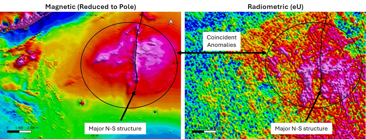
Figure 1: Results of the large scale high-resolution geophysical surveys at Copper Mountain.
Note that positioning information has been withheld for strategic reasons.
To view an enhanced version of this graphic, please visit:
https://images.newsfilecorp.com/files/6301/285877_f1cf3723f46bda91_002full.jpg
The combined magnetic and radiometric dataset supports the interpretation of a large hydrothermal system capable of hosting additional uranium mineralization beyond historically drilled areas. More than 100 anomaly points have been prioritized for field validation, the vast majority of which are located to the east of the north-south structural corridor (Figure 2).
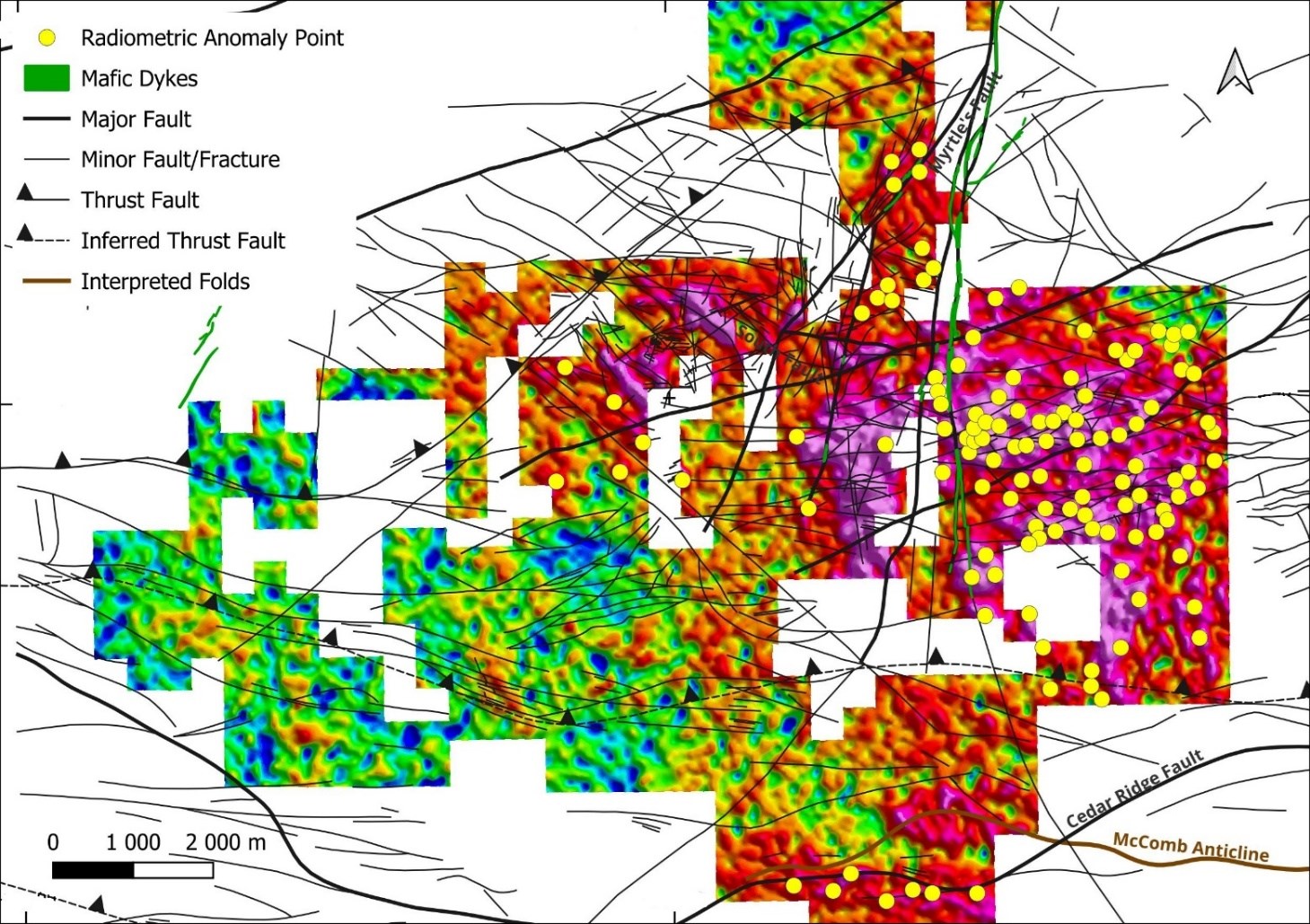
Figure 2: Structural interpretation and radiometric anomaly point selection for ground-truthing relative to property boundaries.
To view an enhanced version of this graphic, please visit:
https://images.newsfilecorp.com/files/6301/285877_f1cf3723f46bda91_003full.jpg
Ground-Truthing Program
In response to these developments, Myriad has now commenced with field work to ground-truth selected radiometric anomaly points. The aim of the field work is to:
Initial results are consistent with airborne anomaly responses (Figure 3). Further updates will follow as work progresses.
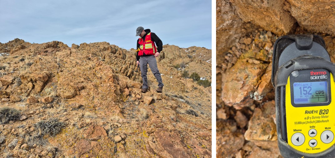
Figure 3: Ground-truthing of radiometric anomaly points commenced last week. This reading is over 100x background.
To view an enhanced version of this graphic, please visit:
https://images.newsfilecorp.com/files/6301/285877_f1cf3723f46bda91_004full.jpg
Geophysical Survey
The survey was completed by Precision Geosurveys, based out of Reno, Nevada, using an Airbus AS350 helicopter. The survey area covered an extent of approximately 191.8 km2, with a total of 2,114 line-kilometres completed at 100 m line spacing and with 1,000 m tie lines at a flying height of 30 m in a north-south orientation.
Magnetic data was collected using a Scintrex CS-3 (or Geometrics equivalent) cesium vapor airborne magnetometer sensor; sensitivity better than 0.01 nT and sampling rate of 20 Hz providing sample spacings of 1-2 meters, in a nose mounted stinger configuration with 3-axis real-time compensation. Two or more base station magnetometers with integrated GPS time synchronization were used for correction of temporal magnetic variations. Radiometric data was collected using a Medusa gamma spectrometer system: 21 litres of proprietary self-calibrating NaI(Tl) gamma radiation detection crystals with 512 channel output at 1 Hz sampling rate. Position control was achieved using a WAAS-enabled GPS navigation system integrated with pilot steering display and data logger. In good weather conditions, flight line accuracy of +/-8 m from desired track was achieved. Elevation control was achieved using an Opti-Logic laser altimeter (or equivalent) and height-above-ground pilot display and recording.
After the survey was completed, several procedures were undertaken by Precision Geosurveys to ensure that the data met a high standard of quality. Magnetic and radiometric data were converted into Geosoft or ASCII file formats using Nuvia Dynamics and Medusa Gamman software. Further processing was carried out using Geosoft Oasis Montaj 2025.1 geophysical processing software along with proprietary processing algorithms. These included position corrections, lag correction, flight height and digital terrain model corrections, magnetic processing, flight compensation, temporal variation correction, heading correction, IGRF removal, levelling and micro-levelling. Outputs for magnetic data included Reduction to Magnetic Pole (RTP), Calculation of Horizontal Gradient (CHG), Calculation of Vertical Gradient (CVG), Analytic Signal (AS). Radiometric processing and outputs involved Aircraft and Cosmic Background Extractions, Radon Finder, Full Spectrum Elevation Airborne Correction, Conversion to Apparent Radioelement Concentrations, Radiometric Ratios and Ternary Radioelement Image Map.
Qualified Person and Data Verification
The scientific or technical information in this news release respecting the Company's Copper Mountain Project has been reviewed and approved by George van der Walt, MSc., Pr.Sci.Nat., FGSSA, Myriad's consulting geologist and a Qualified Person as defined in National Instrument 43-101 - Standards of Disclosure for Mineral Projects. Mr. van der Walt has verified the information disclosed by reviewing all available data on which such information is based. There were no limits on the verification process.
About Myriad Uranium Corp.
Myriad Uranium Corp. holds a 75% interest in the Copper Mountain Uranium Project in Wyoming, USA, with a definitive agreement in place to acquire the remaining 25% interest from Rush Rare Metals Corp. Copper Mountain hosts multiple historic uranium deposits and past-producing mines, including the Arrowhead Mine (approximately 500,000 lbs U₃O₈ produced). The district saw extensive exploration and development by Union Pacific in the late 1970s, including approximately 2,000 boreholes and advanced mine planning prior to uranium market downturn conditions in 1980. Union Pacific is estimated to have invested approximately C$117 million (2024 dollars) in exploration and development at Copper Mountain, generating significant historical resource estimates. The Company also holds a 100% interest in the Red Basin Uranium Project in New Mexico, hosting near-surface mineralization with expansion potential.
A news release detailing a comprehensive assessment of Copper Mountain's uranium endowment by Bendix Engineering for the US Department of Energy published in 1982 can be viewed here.
For further information, please refer to Myriad's disclosure record on SEDAR+ (www.sedarplus.ca), contact Myriad by telephone at +1.604.418.2877, or refer to Myriad's website at www.myriaduranium.com.
Myriad Contacts:
Thomas Lamb
President and CEO
tlamb@myriaduranium.com
Forward-Looking Statements
This news release contains "forward-looking information" that is based on the Company's current expectations, estimates, forecasts and projections. This forward-looking information includes, among other things, the Company's business, plans, outlook and business strategy. The words "may", "would", "could", "should", "will", "likely", "expect," "anticipate," "intend", "estimate", "plan", "forecast", "project" and "believe" or other similar words and phrases are intended to identify forward-looking information. The reader is cautioned that assumptions used in the preparation of any forward-looking information may prove to be incorrect, including with respect to the Company's business plans respecting the exploration and development of the Company's mineral properties, the proposed work program on the Company's mineral properties and the potential and economic viability of the Company's mineral properties. Forward-looking information is subject to known and unknown risks, uncertainties and other factors that may cause the Company's actual results, level of activity, performance or achievements to be materially different from those expressed or implied by such forward-looking information. Such factors include, but are not limited to: changes in economic conditions or financial markets; increases in costs; litigation; legislative, environmental and other judicial, regulatory, political and competitive developments; access to minerals where the surface rights above them have not been settled; and technological or operational difficulties. This list is not exhaustive of the factors that may affect our forward-looking information. These and other factors should be considered carefully, and readers should not place undue reliance on such forward-looking information. The Company does not intend, and expressly disclaims any intention or obligation to, update or revise any forward-looking information whether as a result of new information, future events or otherwise, except as required by applicable law.
The CSE has not reviewed, approved or disapproved the contents of this news release.
To view the source version of this press release, please visit https://www.newsfilecorp.com/release/285877
News Provided by TMX Newsfile via QuoteMedia