The Conversation (0)

Appia Rare Earths & Uranium Corp. (CSE: API,OTC:APAAF) (OTCQB: APAAF) (FSE: A0I0) (MUN: A0I0) (BER: A0I0) (the "Company" or "Appia") is pleased to announce that newly processed SPARTAN Magnetotelluric ("MT") survey data along 3 lines (Figure 1) has been received. The Company views the newly processed MT results, in combination with their previous geophysical datasets, as extremely encouraging. After initial review, they have identified a highly prospective drill target corridor on Line 2 at the Company's 100 percent owned Otherside Uranium Property (the "Property") in Saskatchewan's Athabasca Basin, where targets P-09, P-09A, and P-10 (Figure 1) occur within a major electromagnetic (EM) conductor breakoffset that displays some geophysical similarities to the structural setting of Cameco's McArthur River uranium deposit.
Cameco's McArthur River uranium mine is the world's largest super high-grade uranium mine and remains one of the Athabasca Basin's premier uranium operations.
Line 2 cuts across the central break of the approximately 49-km long Otherside conductor trend. This area has been a key part of Appia's exploration thesis since the Property was originally staked several years ago, as the large conductor offset near the center of the claim block was recognized as a potentially favourable structural setting for Athabasca-style unconformity-type uranium mineralization.
The newly processed MT data has now provided stronger support for the Company's original interpretation. Within the area of the conductor break surveyed by Line 2, and specifically in the area of proposed drill targets P-09, P-09A, and P-10, the data has identified a combination of geophysical features (Figure 2) that Appia considers highly prospective. These include:
Tom Drivas, CEO of Appia, commented:
"The newly processed MT data from Line 2 has identified what we believe is the most compelling drill target area at Otherside. Drill targets P-09, P-09A, and P-10 occur within a major conductor break and display several geophysical features that strengthen our original uranium exploration model for the Property. This exciting development is pointing us toward a focused target area with characteristics reminiscent of Cameco's world-renowned McArthur River super high grade uranium deposit, and we are eager to advance the Property toward drilling as soon as possible."
The above-mentioned combination of geophysical features provides a strong rationale for drill testing. At McArthur River, uranium mineralization is associated with the P2N Thrust Fault and associated P2 North conductor, where unconformity offset, sandstone fracturing, alteration, and structurally controlled mineralization occur near the contact between crystalline basement rocks and the overlying Athabasca sandstone (Figure 3). The Line 2 target area at Appia's Otherside Uranium Property displays a similar combination of key geophysical features, which further supports the Company's view that this area represents a high-priority drill target.
The physical responses of the chimney-like structures at the Property signify highly altered, dense quartz-rich zones indicative of a major hydrothermal fluid pathway. High concentrations of tourmaline (e.g., magnesium-rich dravite with a density of 3.03 to 3.18 g/cm³) combined with pervasive silicification decrease porosity and significantly increase rock density. This signature points toward major hydrothermal fluid movement within/near a fault system(s) with alteration halos of tourmaline, quartz, and illite, a primary vector for unconformity-type uranium deposits, like the McArthur River ingress/egress type (Figure 4).
Other notable anomalies along Line 2 also appear to display interpreted chimney-like geophysical features extending upward from depth toward the surface or near-surface environment. These features may represent potential structural pathways for hydrothermal fluids and could indicate favourable conditions for additional unconformity-type uranium mineralization.
The processed data from Lines 1 and 3 are currently under further development and analysis. However, based on the current interpretation, Line 2 has emerged as the immediate top priority area for follow-up exploration drilling.
Appia is open to strategic partnership opportunities that may assist in advancing the Property through the next phase(s) of exploration.
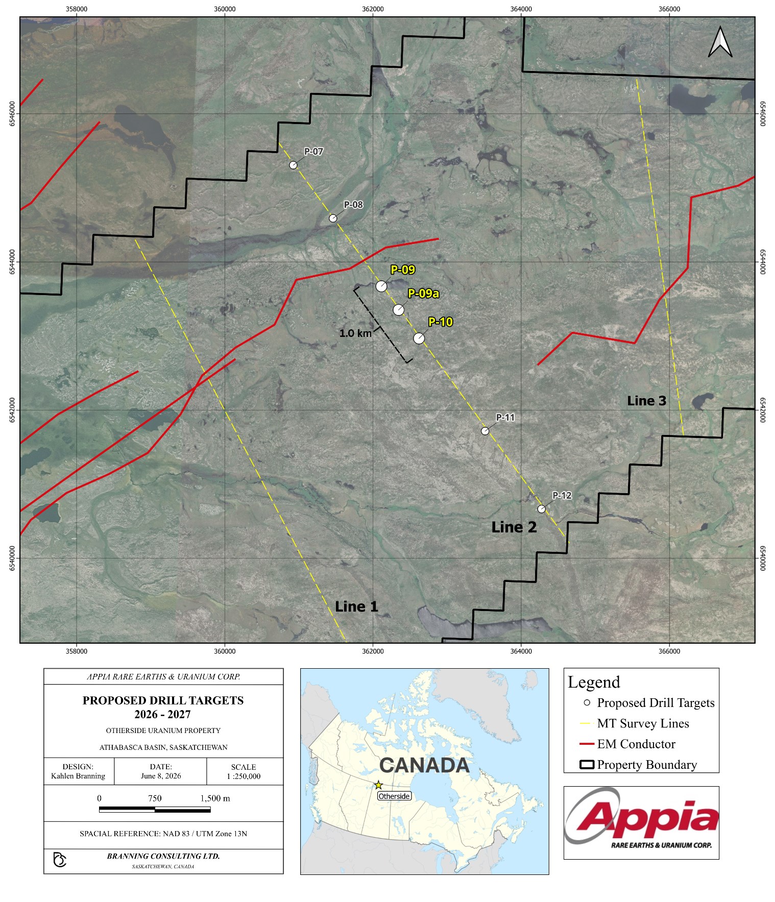
Figure 1 - MT Survey Lines and Drill Targets - Otherside Uranium Property, Saskatchewan. Source: Google Earth Satellite Image - QGIS
To view an enhanced version of this graphic, please visit:
https://images.newsfilecorp.com/files/5416/303213_7fc146fe942eebda_001full.jpg
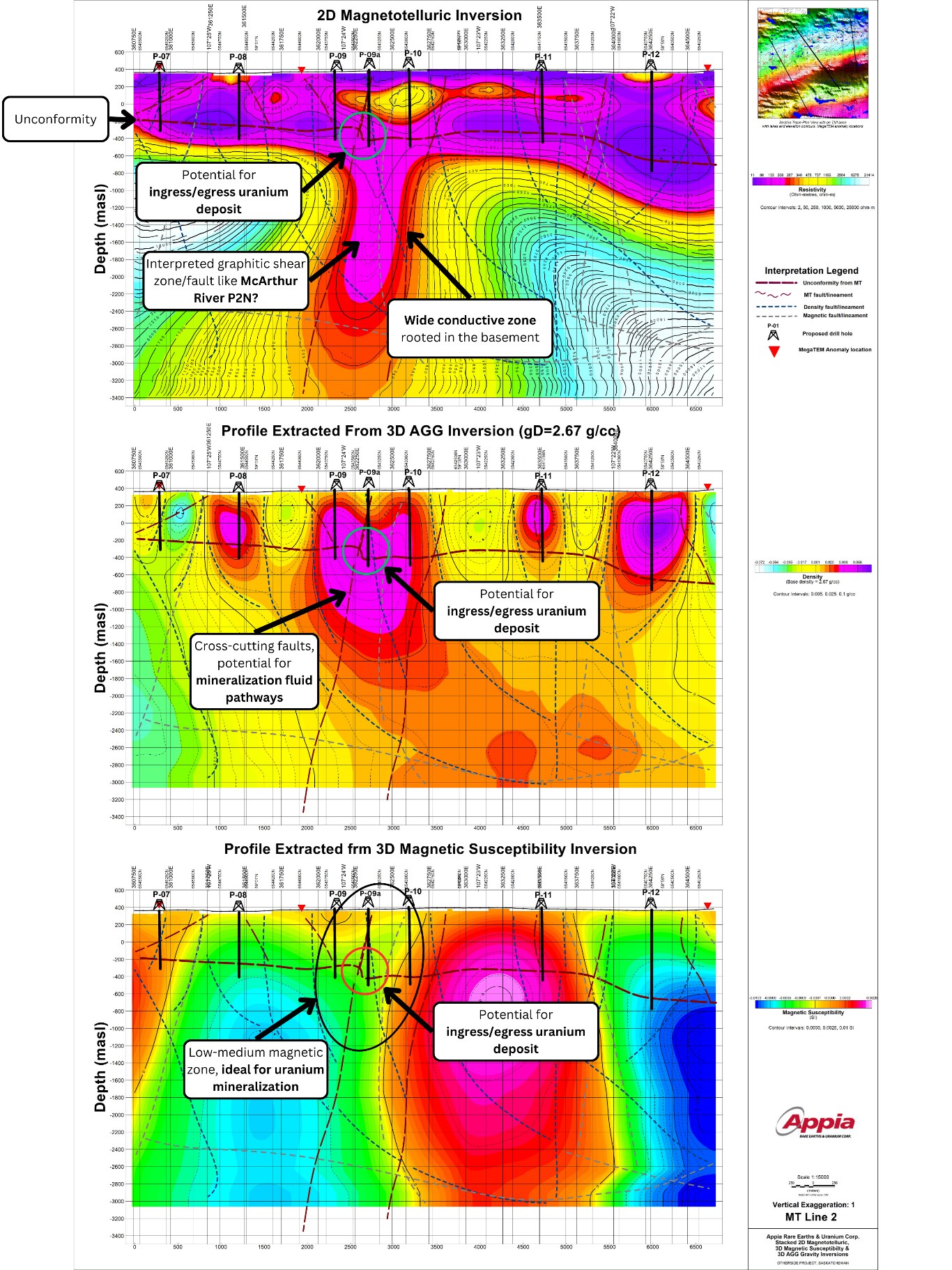
Figure 2 - Line 2 - Magnetotellurics, density, and magnetic survey anomalies showcasing a geological setting that may be indicative of an ingress/egress-type mineralization model similar to McArthur River's prolific uranium deposit.
To view an enhanced version of this graphic, please visit:
https://images.newsfilecorp.com/files/5416/303213_7fc146fe942eebda_002full.jpg
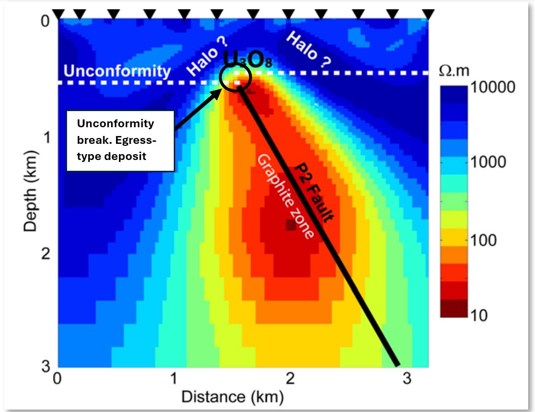
Figure 3 - Resistivity model from the McArthur River AMT dataset (Tuncer et al., 2006). Image modified by Appia on June 24, 2026. Click here for the full report.
To view an enhanced version of this graphic, please visit:
https://images.newsfilecorp.com/files/5416/303213_appia3.jpg
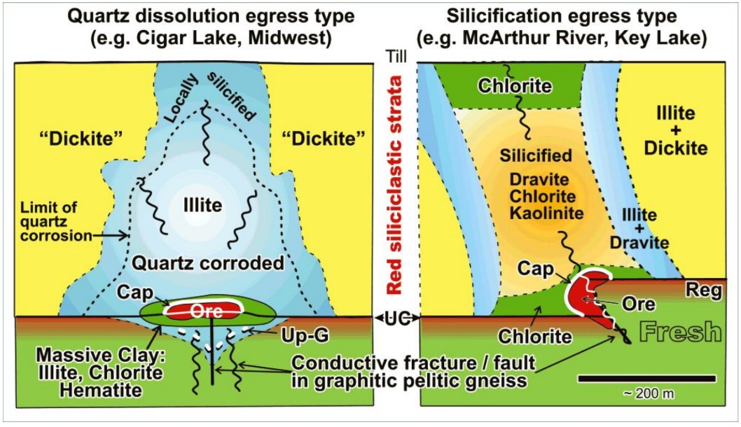
Figure 4 - Typical egress-type deposit models in the Athabasca Basin (Jefferson et al., 2007). Unconformity fault break and conductive pathway coinciding with Otherside geophysical signatures. Click here for the full report.
To view an enhanced version of this graphic, please visit:
https://images.newsfilecorp.com/files/5416/303213_7fc146fe942eebda_007full.jpg
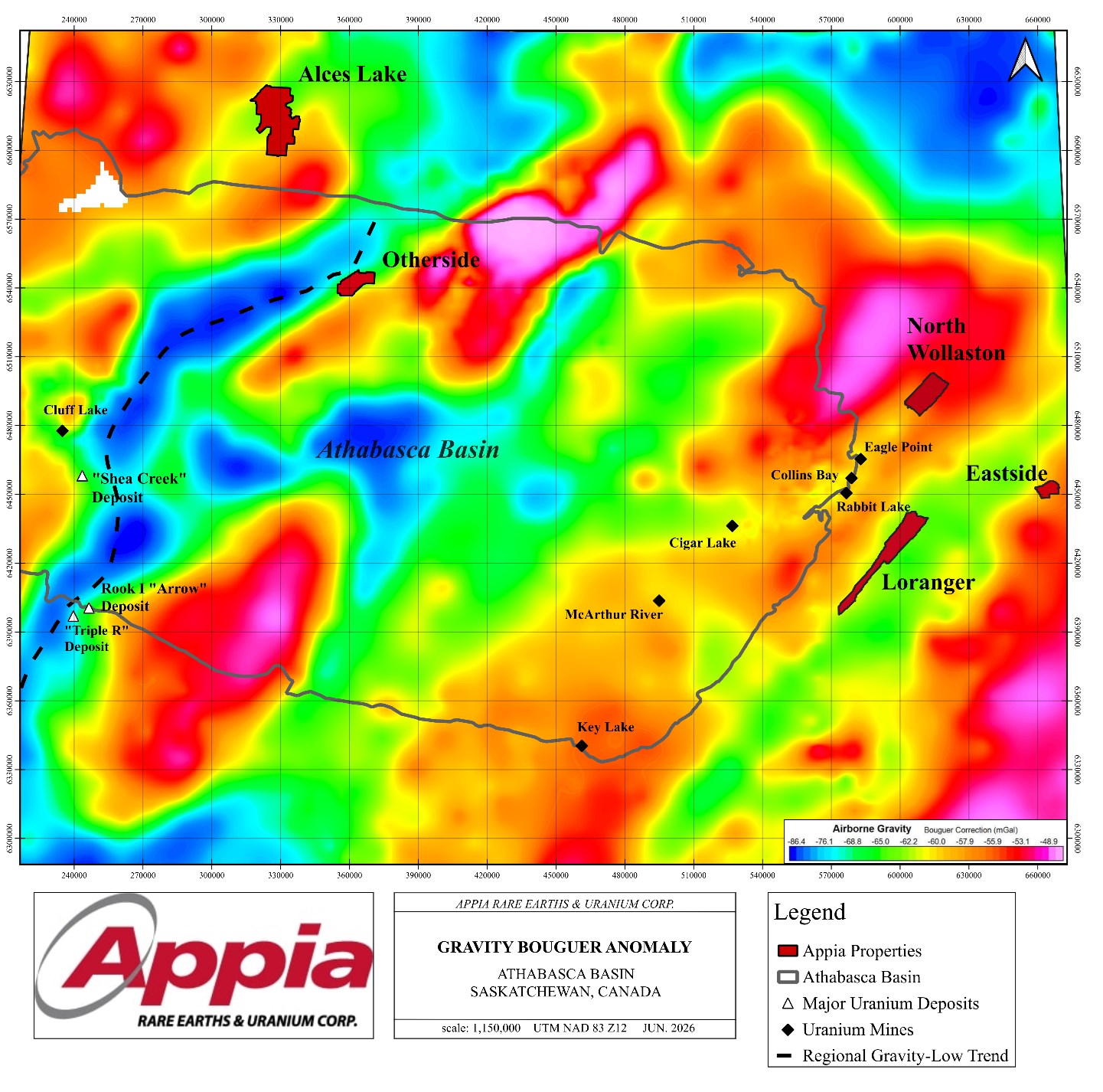
Figure 5 - Regional Athabasca Basin gravity map. Major Athabasca Basin Uranium Deposits Associated with the Same Regional Gravity Low Trend as Appia's Otherside Uranium Property. Saskatchewan GeoAtlas Bouguer Gravity Map.
To view an enhanced version of this graphic, please visit:
https://images.newsfilecorp.com/files/5416/303213_7fc146fe942eebda_008full.jpg
References
Government of Saskatchewan. Saskatchewan Bouguer Gravity Map. Saskatchewan GeoAtlas,
Government of Saskatchewan, accessed 24 June 2026. GeoAtlas,
gisappl.saskatchewan.ca/Html5Ext/index.html?viewer=GeoAtlas.
Google Earth. Otherside Uranium Property, Saskatchewan, Canada. Google, 2024, accessed 24 June 2026.
Jefferson, C. W., D. J. Thomas, S. S. Gandhi, P. Ramaekers, G. Delaney, D. Brisbin, C. Cutts, P. Portella and R. A. Olson, 2007. Unconformity associated uranium deposits, in Jefferson, C.W., and Delaney, G., eds., EXTECH IV: Geology and Uranium EXploration TECHnology of the Proterozoic Athabasca Basin, Saskatchewan and Alberta: Geological Survey of Canada, Bulletin 588 (also Saskatchewan Geological Society, Special Publication 18; Geological Association of Canada, Mineral Deposits Division, Special Publication 4).
Tuncer, V., M. J. Unsworth, W. Siripunvaraporn and J. A. Craven, 2006. Exploration for unconformity type uranium deposits with audio magnetotelluric data: A case study from the McArthur River Mine, Saskatchewan (Canada), Geophysics, 71 (6), B201 - B209.
About the Otherside Project
The Otherside Project is strategically located within the prolific, uranium-bearing Athabasca Basin of Saskatchewan, Canada. This area is renowned for its significant uranium deposits and conditions that have historically led to major high-grade uranium discoveries.
The Otherside Property shares similar geological and geophysical signatures to known high-grade, large-tonnage uranium deposits like McArthur River's world-renowned uranium deposit. Such signatures include long structural corridors hosting multiple conductors with associated magnetic gradients and gravity low areas.
Otherside's property area is 10,441.88 hectares and is 100% owned by Appia.
Qualified Person
The technical content in this news release was reviewed and approved by Dr. Irvine R. Annesley, P.Geo., Senior Exploration Advisor of Appia and a Qualified Person as defined by National Instrument 43-101.
About Appia Rare Earths & Uranium Corp.
Appia is a publicly traded Canadian company in the rare earth element and uranium sectors. The Company holds a 25% interest in Ultra Rare Earth Inc. ("Ultra USA") and Ultra USA indirectly holds a 100% interest in the Ultra Hard Rock and Ultra IAC Projects, which total 42,932.24 ha. in size and are located within the state of Goiás in Brazil (see June 1, 2026 Press Release here).
The Company is also focusing on delineating high-grade critical rare earth elements and gallium on the Alces Lake property and exploring for high-grade uranium in the prolific Athabasca Basin on its Otherside, Loranger, North Wollaston, and Eastside properties. The Company holds the surface rights to exploration for 94,982.39 hectares (234,706.59 acres) in Saskatchewan. The Company also has a 100% interest in 13,008 hectares (32,143 acres), with rare earth elements and uranium deposits over five mineralized zones in the Elliot Lake Camp, Ontario.
Appia has 194.9 million common shares outstanding, 206.6 million shares fully diluted.
Cautionary note regarding forward-looking statements: This News Release contains forward-looking statements which are typically preceded by, followed by or including the words "believes", "expects", "anticipates", "estimates", "intends", "plans" or similar expressions. Forward-looking statements are not a guarantee of future performance as they involve risks, uncertainties and assumptions. We do not intend and do not assume any obligation to update these forward-looking statements and shareholders are cautioned not to put undue reliance on such statements.
Neither the Canadian Securities Exchange nor its Market Regulator (as that term is defined in the policies of the CSE) accepts responsibility for the adequacy or accuracy of this release.
For more information, visit www.appiareu.com
As part of our ongoing effort to keep investors, interested parties and stakeholders updated, we have several communication portals. If you have any questions online (X, Facebook, LinkedIn) please feel free to send direct messages.
Contact:
| Tom Drivas CEO and Director (416) 876-3957 tdrivas@appiareu.com | Jason Bagg VP Corporate Development (647) 874-5278 jbagg@appiareu.com |
To view the source version of this press release, please visit https://www.newsfilecorp.com/release/303213
News Provided by TMX Newsfile via QuoteMedia