The Conversation (0)

Salazar Resources Limited (TSXV: SRL,OTC:SRLZF) (OTCQB: SRLZF) (FSE: CCG) ("Salazar" or the "Company") is pleased to report results from its recent rock and soil sampling program and detailed geological mapping at its 100%-owned Monja Project in Ecuador. These results build upon the Company's previously reported (press release from April 8, 2026) identification of a high-priority copper-gold porphyry target and further demonstrate the scale and continuity of mineralization at surface.
Highlights
CEO Commentary
Freddy Salazar, President and CEO, commented: "These results continue to support our interpretation of Monja as a well-developed copper-gold porphyry system. The consistency of copper values across surface samples, combined with encouraging gold grades and strong veining observed in mapping, provides us with increased confidence in the scale of the system."
Rock Sampling Results
Following the results reported on April 8, 2026, Salazar has collected a total of 99 rock samples across the Monja Project target area, consisting primarily of rock chip samples with two channel samples. Results show that 64 samples (64%) returned copper values greater than 300 ppm, including 20 samples (20%) exceeding 1,000 ppm Cu. Table 1.
Mineralization is hosted within granodiorite and quartz-feldspar porphyry and occurs as hydrothermal breccias (breccia pipes) and stockwork veining. Observed sulphide mineralization includes chalcopyrite, pyrite, and bornite and is accompanied by silica, mostly in veins type B and D. Alteration is characterized by propylitic assemblages that transition into phyllic and argillic zones, marked by chlorite-rich intervals grading into silica- and sericite-dominated alteration. Localized occurrences of K-feldspar, magnetite, and green sericite are also present.
The distribution of alteration styles is consistent with a vertically and laterally zoned porphyry system and may represent either a high-level exposure or a structurally complex, telescoped system¹. Further work is required to refine the interpretation.
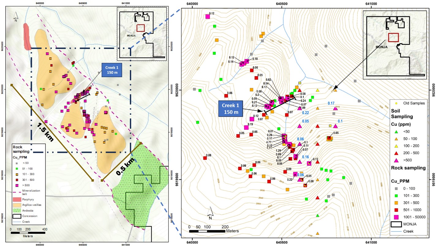
Map 1. Lithology Map, Sample locations, and Copper results in rock and soil samples
To view an enhanced version of this graphic, please visit:
https://images.newsfilecorp.com/files/4631/303350_e49231e19404c9a6_002full.jpg
Table 1. Rock Samples with values > 1,000 ppm Cu
| SAMPLE | TYPE | WIDTH | Au (ppm) | Ag (ppm) | Cu (ppm) | Mo (ppm) |
| 51744 | Chips | 3 | 0.608 | 10.4 | 12910 | 9 |
| 51748 | Chips | 5 | 0.644 | 1.5 | 6250 | 4 |
| 54238 | Chips | 4 | 0.04 | 1.4 | 1741 | 109 |
| 200073 | Chips | 4 | 0.081 | 0.9 | 2354 | 28 |
| 200079 | Chips | 4 | 0.613 | 2.7 | 10940 | 10 |
| 200098 | Chips | 3 | 0.028 | 0.6 | 1058 | 31 |
| 200101 | Chips | 3.5 | 0.989 | 10.3 | 17070 | 162 |
| 200113 | Chips | 3 | 0.054 | 1.2 | 1222 | 3 |
| 200237 | Chips | 2.5 | 0.024 | 0.9 | 1529 | 11 |
| 700154 | Channel | 3 | 0.252 | 1.2 | 5363 | 4 |
| 700155 | Channel | 3 | 0.143 | 0.5 | 1719 | 4 |
| 700156 | Chips | 3 | 0.064 | 0.4 | 1751 | 34 |
| 700157 | Chips | 3 | 0.05 | 0.2 | 1233 | 13 |
| 700162 | Chips | 3 | 0.061 | 0.4 | 1959 | 130 |
| 700166 | Chips | 3.5 | 0.04 | 0.5 | 1317 | 18 |
| 700167 | Chips | 3 | 0.043 | 0.9 | 2094 | 112 |
| 700222 | Chips | 4 | 0.061 | 1.3 | 2227 | 44 |
| 700228 | Chips | 4 | 0.012 | 0.4 | 1245 | 47 |
| 700229 | Chips | 2.5 | 0.012 | 0.6 | 1888 | 47 |
| 700246 | Chips | 3 | 0.053 | 0.4 | 1441 | 3 |
Note: The rock chip samples described in this release are selective in nature and are taken to identify the presence of mineralization.
Soil Sampling
A total of 23 soil samples were collected along three north-south oriented lines on a 100 m by 100 m grid pattern. Sampling targeted a soil-covered topographic high located east of a previously reported high-grade copper occurrence, including a sample grading 4.7% Cu (press release from April 8, 2026).
Samples were collected from soil B at depths ranging from 0.5 to 2.5 meters using an auger. Sixteen samples (70%) returned copper values exceeding 100 ppm. Table 2.
These results are considered encouraging and suggest the presence of copper mineralization over an area of approximately 180,000 m². Follow-up work will include additional infill soil sampling to better define this target.
Table 2. Soil Samples with values > 100ppm Cu
| SAMPLE | DEPTH (m) | Au (ppm) | Mo(ppm) | Cu(ppm) |
| 53501 | 1.2 | 0.026 | 9 | 244 |
| 53502 | 0.6 | 0.035 | 4 | 2242 |
| 53503 | 1.5 | 0.033 | 12 | 543 |
| 53504 | 1 | 0.005 | 2 | 572 |
| 53505 | 0.8 | 0.016 | 5 | 1599 |
| 53506 | 0.9 | 0.102 | 133 | 573 |
| 53507 | 1.9 | 0.013 | 2 | 197 |
| 53509 | 1.95 | 0.020 | 6 | 217 |
| 53511 | 1 | 0.007 | 2 | 218 |
| 53512 | 0.5 | 0.054 | 16 | 398 |
| 53514 | 1.1 | 0.018 | 7 | 255 |
| 53518 | 2.5 | 0.033 | 2 | 403 |
| 53519 | 1.8 | 0.020 | 2 | 246 |
| 53521 | 2.3 | 0.010 | 2 | 116 |
| 53524 | 0.85 | 0.018 | 16 | 1720 |
| 53525 | 1.2 | 0.028 | 3 | 996 |
Detailed Geological Mapping -Creek 1
Detailed mapping along a southwest-to-northeast trending creek ("Creek 1"), measuring approximately 150 m, has provided continuous exposure of the mineralized system.
Mapping identified well-developed stockwork veining, with densities averaging approximately 10 veins per meter. The dominant structural orientation is northwest-southeast.
Most observed veins are quartz-rich and contain pyrite, chalcopyrite, and bornite, Type B. Some veins exhibit sericite alteration halos, proposing an overprinting of phyllic alteration with Type D veins². Image1.
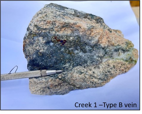
Image 1. Creek 1 - Type B vein with quartz, chalcopyrite, bornite and pyrite.
To view an enhanced version of this graphic, please visit:
https://images.newsfilecorp.com/files/4631/303350_e49231e19404c9a6_003full.jpg
These observations enhance the Company's understanding of the structural controls and mineralization style within the system. A detailed geologic map of Creek 1 is available on Salazar's website: https://salazarresources.com/projects/100-salazar-owned/monja/.
Interpretation and Next Steps
This recent geochemical and mapping campaign focused on the central area of the previously reported 2km by 1km porphyry core (press release from April 8, 2026). This recent work confirms copper and gold mineralization in the focused 1.5 by 0.5 km area km.
The boundaries of the mineralization are not defined yet; thus, the Company plans to continue surface geochemical work and mapping in the remaining parts of the porphyry core while further planning future geophysical surveys to refine possible drill targets.
Monja Project
The 100%-owned Monja Project is located in Loja Province, Ecuador, and covers 9,088 ha across two mineral concessions. For a location map, please refer to the Company's website.
About Salazar Resources Limited
Salazar Resources Limited (TSXV: SRL,OTC:SRLZF) (OTCQB: SRLZF) (FSE: CCG) is a Canadian junior exploration company focused on the discovery and development of mineral deposits in Ecuador. The Company's strategy combines in-house geological expertise with a disciplined, systematic approach to project generation and advancement. For further information, please contact Nick DeMare, Director, at ndemare@chasemgt.com or at 604-685-9316. Please also visit our website at https://salazarresources.com.
Reference
¹Lowell, J.D., and Guilbert, J.M., 1970. Lateral and vertical alteration-mineralization zoning in porphyry ore deposits. Economic Geology, 65(4), 373-408. https://doi.org/10.2113/gsecongeo.65.4.373.
²Candela, P. A., & Piccoli, P. M. (2005). Magmatic processes in the development of porphyry-type ore systems. In J. W. Hedenquist, J. F. H. Thompson, R. J. Goldfarb, & J. P. Richards (eds.), Economic Geology: One Hundredth Anniversary Volume (pp. 25-37). Society of Economic Geologists.
QA/QC Program
Rock samples were submitted to Bureau Veritas Ecuador, an independent accredited laboratory, for analysis and were prepared in Quito and sent to be analyzed in Lima using 44-multielement analysis by aqua regia digestion and Optical Emission Spectroscopy (ICP-OES) while Ag, Cu,Pb, Zn, As, Ni, Co determination was done by Aqua Regia Digestion and Atomic Absorption Spectroscopy(AAS). Gold analysis was completed by lead collection fire assay fusion with AAS finish (<10 g/t Au) and the overlimits were completed by fire assay fusion with gravimetric finish. Soil samples were prepared in Burea Veritas, Quito, an independent accredited laboratory, by drying and pulverizing to 95% 150 mesh then sent to Bureau Veritas, Callao to be analyzed using 44 elements aqua regia digestion with ICP-AES finish. Gold analysis for soil samples was done using Lead Collection Fire -Assay with AAS finish. The Company implements a quality assurance/quality control (QA/QC) program that includes chain of custody and the insertion of standards, blanks, and duplicates.
Qualified Person
Mr. Kieran Downes, the Company's Qualified Person ("QP") as defined by National Instrument 43-101 - Standards of Disclosure for Mineral Projects, has reviewed and approved the technical content of this news release. In accordance with TSX Rules and Policies, Part 1, Section 1.5, the Company further clarifies that Mr. Downes is independent of the Company (as defined under NI 43-101).

To view the source version of this press release, please visit https://www.newsfilecorp.com/release/303350
News Provided by TMX Newsfile via QuoteMedia