The Conversation (0)

Saga Metals Corp. (TSXV: SAGA,OTC:SAGMF) (OTCQB: SAGMF) (FSE: 20H) ("SAGA" or the "Company"), a North American exploration company focused on critical mineral discoveries, is pleased to report initial results from a helicopter-borne Full Tensor Magnetic Gradiometry ("FTMG") survey completed by Dias Airborne Limited ("Dias") using Dias's QMAGT system over the central oxide-layering corridor of the 100%-owned Radar Titanium-Vanadium-Iron Project near Cartwright, Labrador.
The QMAGT survey was completed April 27-28, 2026 and provides the Company's highest-resolution magnetic dataset to date over the central oxide layers of the Dykes River Intrusive Complex. The data are interpreted to image internal magnetic layering, the Trapper North antiformal geometry, and a continuous magnetic trend along the southern limb from the drill-tested Trapper South area toward the untested Falcon Zone.
Michael Garagan, Chief Geological Officer & Director, commented: "The QMAGT survey materially improves our understanding of the geometry and continuity of the magnetic oxide-layering at Radar. Most importantly, it provides a clearer basis for prioritizing the remaining MRE drilling at in the Trapper Zone as well as follow-up drilling in Hawkeye and Falcon Zones. The main magnetic anomaly stands out at a size that now compares directly, at scale, with the world's largest titanium-vanadium deposits using only its surface expression. When you factor in the substantial true thickness of high-grade oxide mineralization we're intersecting in our drill program, the project's potential becomes even more compelling. While drilling is required to confirm the source, grade, and thickness of the new anomalies, the survey gives us a stronger structural and geophysical framework for the next phase of exploration."
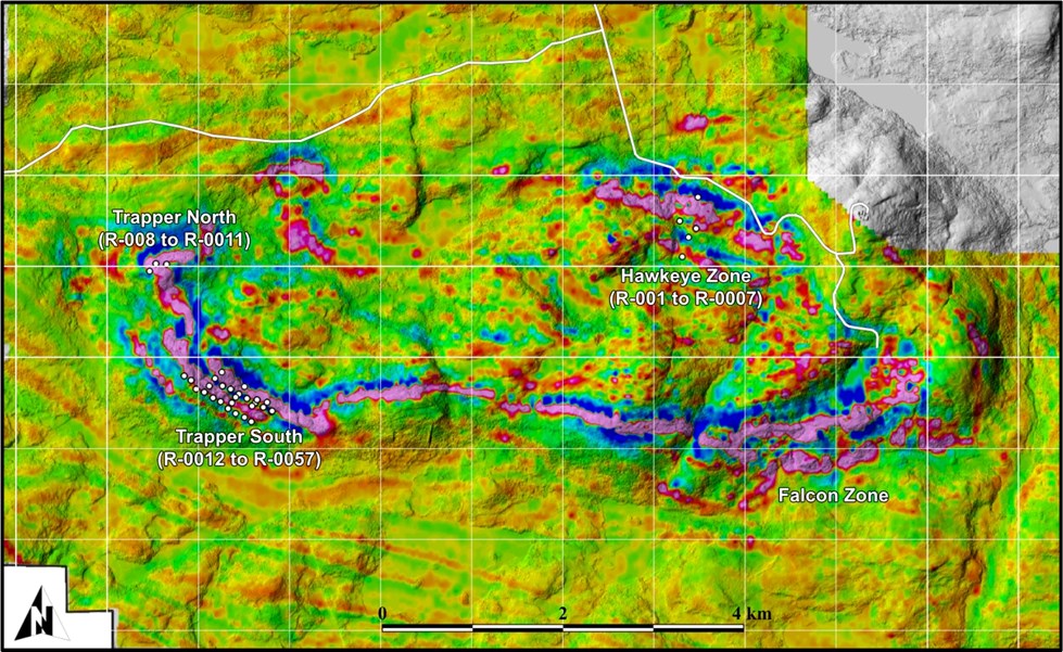
Figure 1: Dias QMAGT vertical gradient (Bzz) image of the central Dykes River Intrusive Complex. SAGA diamond drill hole collars (white circles) are labeled by zone: Hawkeye (R-0001 to R-0007), Trapper North (R-0008 to R-0011), and Trapper South (R-0012 to R-0057, including the ongoing 2026 Mineral Resource Estimate drill program). The vertical gradient resolves the layered VTM architecture as multiple sub-parallel high-amplitude (pink) bands, imaging the open, north-plunging Trapper North antiform within the survey footprint. It independently resolves the Hawkeye Lower Cumulate Layer as parallel sub-bands within its own structural domain north of the antiform.
To view an enhanced version of this graphic, please visit:
https://images.newsfilecorp.com/files/12336/298285_a0312093e4696a51_001full.jpg
Dias QMAGT Survey Highlights:
157 north-south flight lines at 75 m line spacing, covering the central oxide-layering corridor of the Property, acquired April 27-28, 2026.
Full tensor delivery: corrected total field (TF), six gradient components (Bxx, Bxy, Bxz, Byy, Byz, Bzz), tensor invariants I₁ and I₂, and derived attributes (Total Amplitude, Normalized Source Strength, Normalized Amplitude of Signal, Total Horizontal Gradient, and Total Horizontal Curvature).
The full-tensor magnetic-gradient data were processed into terrain-corrected grids referenced to a North-East-Down (NED) coordinate frame, enabling consistent interpretation of the horizontal and vertical magnetic-gradient components.
Interpreted magnetic continuity from Trapper South toward the Falcon Zone is imaged. The Trapper South oxide system, which has been drill tested as part of the 2026 MRE drilling program, occurs along the same southern-limb magnetic trend as the untested Falcon Zone. Follow-up drilling is planned to validate the magnetic trend represents the same, continuous VTM mineralization, as well as determine grade, thickness, and geometry.
Trapper North antiform imaged directly. A closed-loop Bzz response with the southern hinge and northeastern limb clearly defined. The full antiform is contained within the QMAGT survey footprint.
Hawkeye Lower Cumulate Layer independently resolved. Hawkeye sits east of the Trapper zone within its own structural domain on the opposite side of the entire cumulate oxide formation. The 300-400 m thick Lower Cumulate Layer modelled from 2024 ground magnetics and tested by drillholes R-0001 to R-0007 is now imaged in QMAGT as multiple sub-parallel high-amplitude bands, supporting the same layered architecture observed at Trapper.
Falcon Zone - priority follow-up target. A coherent, high-amplitude Bzz / Normalized Source Strength response occurs approximately 5 km east of the current Trapper South drilling. The target is the largest zone on the property and has not yet been drill-tested. Its prospectivity is based on the new QMAGT response, limited selected-sample information, and historic geophysical compilations. The geophysical response is comparable in amplitude and tensor character to responses observed over drill-tested parts of Trapper South; however, this comparison is geophysical only and does not imply similar grade, thickness, tonnage, or economic potential.
Geological Significance - The Dykes River Layered Intrusion in Full Tensor Detail:
The Radar Property entirely encloses the Mesoproterozoic Dykes River Intrusive Complex, a layered mafic intrusion mapped at approximately 160 km² that hosts orthomagmatic VTM mineralization across a 20+ km arcuate strike extent. Prior magnetic coverage of the central corridor consisted of regional NRCAN/NLGS aeromagnetic data - which defined the broad arcuate anomaly but did not resolve its internal architecture and high-resolution ground magnetics covering only small portions of the Hawkeye Zone, Trapper Zone, and North Target. Ground readings at Trapper in July 2025 reached 115,498 nT, approaching the GSM-19 magnetometer's 120,000 nT detection ceiling, prompting a manual reset of the instrument at its maximum detection.
The Dias QMAGT survey resolves, for the first time at the deposit scale, the internal layering of the intrusion. The corrected total field is intensely magnetized across the Trapper and Hawkeye cores; the vertical gradient (Bzz), Normalized Source Strength, and tensor invariants separate those fused total-field highs into the oxide horizons predicted by the drilling.
Scale Context - The Radar Property in Comparison with the Panzhihua Deposit:
The QMAGT-imaged magnetic footprint of the central Radar oxide-layering corridor represents only a portion of the 24,175-hectare Radar Property, which entirely encloses the approximately 160 km² Dykes River Intrusive Complex. The Property's land position is shown at the same map scale as the digitized ore outline of one of the world's most significant titanium-vanadium-iron deposits in Figure 2, providing visual context for the relative scale of the geological system that hosts the Radar mineralization.
The Panzhihua deposit in Sichuan Province, China, hosts approximately 1,333 million tonnes of vanadiferous titanomagnetite ore at the main Panzhihua intrusion (Zhou et al., 2005), within a broader Panxi mining district whose vanadium-titanomagnetite reserves were estimated by the China Ministry of Land and Resources at approximately 23.7 billion tonnes in 2013. Panzhihua is the world's leading producer of vanadium, contributing over 40% of global V₂O₅ supply.
Modelling of the VTM contents at the Trapper and Hawkeye Zones returned a targeted VTM concentrate very similar to Panzhihua VTM concentrates. Despite an abundance of world resources for Ti ores, the industry continues to prospect for better quality concentrates, principally because of processing costs and waste disposal problems associated with the high iron and trace-element contents of ilmenite and titanomagnetite. The simple, coarse-grained VTM mineralization at Saga Metals' Radar Project has the potential for a clean VTM concentrate with high recovery.
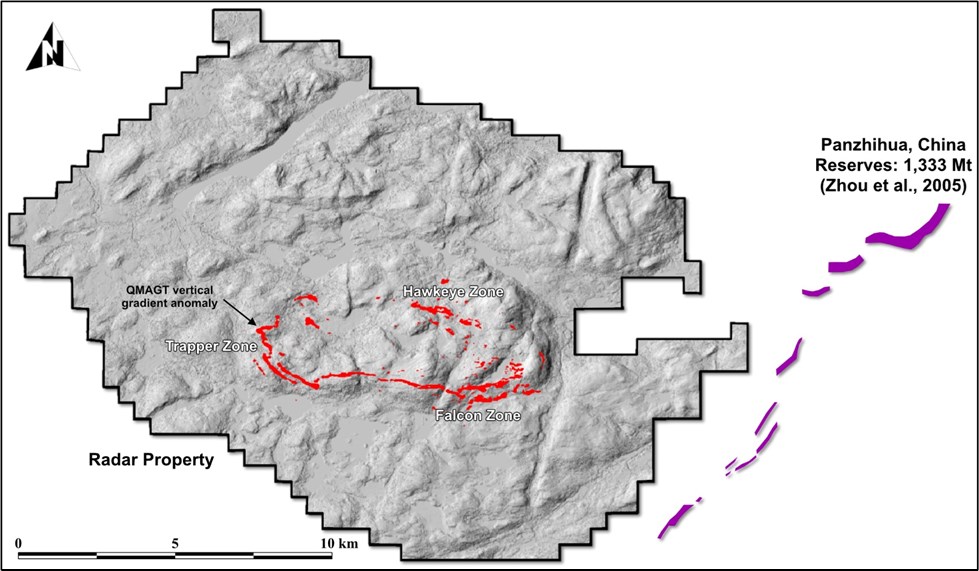
Figure 2: The Radar Property (outlined) with the Dias QMAGT vertical gradient (Bzz) anomaly footprint shown in red (high-amplitude pixels only), shown at the same map scale as the digitized ore outlines of the Panzhihua deposit (Sichuan, China). The QMAGT-imaged central oxide-layering corridor - encompassing the Trapper Zone, Hawkeye Zone, and the new Falcon Zone - is shown for direct visual comparison with the world's most significant titanium-vanadium-iron producers.
To view an enhanced version of this graphic, please visit:
https://images.newsfilecorp.com/files/12336/298285_a0312093e4696a51_002full.jpg
The producing deposit shown in Figure 2 is provided solely for geological and scale-context purposes. The presence of similar regional-scale magnetic or intrusive features at Radar does not imply that the Radar Property hosts similar grades, tonnages, mineral resources, mineral reserves, metallurgy, recoveries, or economics. The Radar Property has no current mineral resource estimate. The maiden mineral resource estimate currently in progress is limited to the Trapper area and remains subject to completion, QP review, and public disclosure in accordance with NI 43-101.
About the Dias QMAGT Survey:
Dias's QMAGT is a helicopter-borne Full Tensor Magnetic Gradiometer based on superconducting quantum interference device ("SQUID") sensors developed by Supracon AG of Jena, Germany. Conventional aeromagnetic surveys measure a single scalar quantity - the strength of the Earth's magnetic field at the sensor. FTMG measures, simultaneously, the complete three-dimensional geometry of how that field changes with position: six independent gradient components recorded at every fiducial. This directional information allows the geophysical interpretation to separate closely spaced magnetic source bodies, sharpen the imaging of their lateral edges, and estimate their depth more reliably than is possible with total-field instruments - capabilities that are particularly valuable when the targets are layered, steeply dipping magnetic bodies such as the VTM-bearing horizons at Radar.
The QMAGT sensor is towed beneath the helicopter to isolate it from rotor motion noise and to deliver high-quality data in rugged terrain. The survey at Radar comprised 157 lines at 75 m line spacing acquired April 27-28, 2026; total line-kilometres, nominal terrain clearance, and final processing parameters will be reported in the Dias final interpretation report, which is currently in preparation.
Radar Critical Minerals Project Overview:
The Radar Property comprises 690 mineral claims across 9 mineral licenses totalling approximately 24,175 hectares in southeastern Labrador, located approximately 10 km south of Cartwright. The Property entirely encloses the Dykes River Intrusive Complex (~160 km² on surface) and is accessible year-round via paved Route 510, a Cartwright logging road and a SAGA-constructed access trail. Infrastructure advantages include the deep-water port at Cartwright, the Cartwright Airport (YRF), and proximity to regional hydroelectric power from Muskrat Falls and Churchill Falls.
To date, SAGA has completed 57 diamond drill holes (R-0001 through R-0057) across the Hawkeye, Trapper North, and Trapper South zones, with 100% of holes intersecting VTM mineralization. Best results to date include:
| DDH | FROM | TO | Length | True Thickness | Fe2O3 | TiO2 | V205 |
| ID | m | m | m | m | % | % | % |
| R-0009 | 94.0 | 181.2 | 87.2 | 84.4 | 50.67 | 10.15 | 0.339 |
| R-0008 | 170.0 | 237.6 | 68.3 | 66.2 | 46.15 | 9.21 | 0.311 |
| R-0010 | 1.5 | 137.0 | 135.5 | 121.7 | 50.03 | 7.87 | 0.352 |
| R-0017 | 73.0 | 140.6 | 67.6 | 54.9 | 55.13 | 7.37 | 0.448 |
| R-0033 | 97.0 | 153.0 | 56.0 | 43.1 | 48.03 | 7.25 | 0.304 |
| R-0016 | 44.0 | 94.6 | 50.6 | 47.1 | 52.05 | 7.21 | 0.375 |
| R-0021 | 96.0 | 127.4 | 31.4 | 16.5 | 53.18 | 7.08 | 0.414 |
| R-0024 | 142.0 | 186.0 | 44.0 | 28.4 | 54.20 | 7.07 | 0.443 |
| R-0034 | 106.1 | 170.0 | 63.9 | 62.8 | 48.61 | 7.01 | 0.344 |
| R-0015 | 73.3 | 174.0 | 100.7 | 88.9 | 38.56 | 6.80 | 0.229 |
Table 1: Top 10 intercepts from the 2025 & 2026 drilling programs at the Trapper Zone
The Trapper Zone has been traced over more than 3 km of continuous magnetic anomaly, with semi-massive to massive oxide intercepts ranging from 46 to 154.77 m per hole. VTM mineralization at Radar is comparable to that of global Fe-Ti-V systems such as Panzhihua (China) and Bushveld (South Africa). Subject to further exploration, resource definition, and metallurgical testing, the Project may represent a potential future strategic source of titanium, vanadium, and iron to North American markets.
Upcoming 2026 Work Program & Exploration Priorities - Radar Project:
The Company's 2026 work program is designed to advance the Radar Project toward a maiden NI 43-101 Mineral Resource Estimate at Trapper and to systematically test the new targets revealed by the Dias QMAGT survey. The program will deliver the geological, structural, geophysical, metallurgical, density, and QA/QC data required to support resource definition. Priorities include:
Complete the Trapper MRE diamond drill program, validate true widths and oxide continuity, and finalize the geological and structural database for resource estimation.
3D magnetic inversion modelling of the Dias QMAGT dataset, constrained by the 2025-2026 drill database, to model the depth extent, geometry, and connectivity of the layered VTM horizons.
Metallurgical test work, including Davis Tube recovery, Satmagan correlation, and preliminary smelting tests on representative samples from each zone, to support process design and the upcoming MRE.
Continued diamond drilling at the Falcon Zone to test the new QMAGT-defined anomaly for VTM mineralization.
Qualified Person
Paul J. McGuigan, P. Geo., is an Independent Qualified Person as defined under National Instrument 43-101 and has reviewed and approved the technical information disclosed in this news release.
About Saga Metals Corp.
Saga Metals Corp. is a North American mining company focused on the exploration and discovery of a diversified suite of critical minerals that support the North American transition to supply security. The Radar Ti-V-Fe Project comprises 24,175 hectares and entirely encloses the Dykes River intrusive complex, mapped at 160 km² on the surface near Cartwright, Labrador. Exploration to date, including 13,809 m of drilling, has confirmed a large, mineralized layered mafic intrusion hosting vanadiferous titanomagnetite (VTM) and ilmenite mineralization with strong grades of titanium and vanadium.
The Company has signed a definitive agreement to acquire 100% of the Wolverine Heavy Rare Earth Element Project in Labrador, a near-surface REE system hosted within a peralkaline caldera complex that shares strong geological similarities with the Tanbreez and Strange Lake deposits. The project features consistent mineralization, with zones spanning 26 km2, including drill assays up to 2.03% TREO with approximately 28% HREO content, and sample assays up to 21.6% TREO.
The Double Mer Uranium Project covers 25,600 hectares and features uranium radiometrics that highlight an 18 km east-west trend, with a confirmed 14 km section producing samples as high as 0.428% U3O8. (2024 Double Mer Technical Report).
Additionally, SAGA owns the Legacy Lithium Project in Quebec's Eeyou Istchee James Bay region. This project spans 65,849 hectares and shares significant geological continuity with other major players in the area, including Rio Tinto, Li-FT Power, SOQUEM, and Loyal Metals.
With a portfolio spanning key commodities critical to the clean energy future, SAGA is strategically positioned to play an essential role in securing critical minerals.
References - Comparable Deposits:
China Ministry of Land and Resources (2013). Mineral Resources Reserves Statistics, Panzhihua-Xichang region, Sichuan Province.
Zhou, M.-F., Robinson, P.T., Lesher, C.M., Keays, R.R., Zhang, C.-J., and Malpas, J. (2005). Geochemistry, petrogenesis and metallogenesis of the Panzhihua gabbroic layered intrusion and associated Fe-Ti-V oxide deposits, Sichuan Province, SW China. Journal of Petrology, 46, 2253-2280.
On Behalf of the Board of Directors
Mike Stier, Chief Executive Officer
For more information, contact:
Rob Guzman, Investor Relations
Saga Metals Corp.
Tel: +1 (844) 724-2638
Email: rob@sagametals.com
www.sagametals.com
Neither the TSX Venture Exchange nor its Regulation Service Provider (as that term is defined in the policies of the TSX Venture Exchange) accepts responsibility for the adequacy or accuracy of this release.
Cautionary Disclaimer
This news release contains forward-looking statements within the meaning of applicable securities laws that are not historical facts. Forward-looking statements are often identified by terms such as "will", "may", "should", "anticipates", "expects", "believes", and similar expressions or the negative of these words or other comparable terminology. All statements other than statements of historical fact, included in this release are forward-looking statements that involve risks and uncertainties. In particular, this news release contains forward-looking information pertaining to the Company's Radar Project. There can be no assurance that such statements will prove to be accurate, and actual results and future events could differ materially from those anticipated in such statements. Important factors that could cause actual results to differ materially from the Company's expectations include, but are not limited to, changes in the state of equity and debt markets, fluctuations in commodity prices, delays in obtaining required regulatory or governmental approvals, environmental risks, limitations on insurance coverage, inherent risks and uncertainties involved in the mineral exploration and development industry, particularly given the early-stage nature of the Company's assets, and the risks detailed in the Company's continuous disclosure filings with securities regulations from time to time, available under its SEDAR+ profile at www.sedarplus.ca. The reader is cautioned that assumptions used in the preparation of any forward-looking information may prove to be incorrect. Events or circumstances may cause actual results to differ materially from those predicted, as a result of numerous known and unknown risks, uncertainties, and other factors, many of which are beyond the control of the Company. The reader is cautioned not to place undue reliance on any forward-looking information. Such information, although considered reasonable by management at the time of preparation, may prove to be incorrect and actual results may differ materially from those anticipated. This cautionary statement expressly qualifies forward-looking statements contained in this news release. The forward-looking statements contained in this news release are made as of the date of this news release, and the Company will update or revise publicly any of the included forward-looking statements only as expressly required by applicable law.

To view the source version of this press release, please visit https://www.newsfilecorp.com/release/298285
News Provided by TMX Newsfile via QuoteMedia