The Conversation (0)

MTB Metals Corp. (TSXV: MTB) (OTCQB: MBYMF) (FSE: M9U) ("MTB" or the "Company") announces that drilling on the Telegraph porphyry project is anticipated to start around August 19. Currently pads are being built and the drills are being mobilized. The first phase of drilling will be testing three areas along 2.5 kilometres of the identified Dok trend.
The geological setting of the Telegraph property is similar to four world-class porphyry copper-gold deposits in the same region, all of which are being advanced by major mining companies. MTB consolidated a 310 square kilometer land package in 2021 and is now exploring this area for the first time on a consolidated basis.
Two holes drilled in 2014 confirmed the presence of a porphyry copper-gold system at Dok, but the holes are interpreted to be peripheral to the heart of the system. For the last 2 years the MTB geological team has been compiling the historic data and systematically exploring the various identified targets with geological alteration and structural mapping, prospecting, shortwave infrared spectroscopy (SWIR), rock sampling, spectral analysis and soil geochemistry. A Volterra 3D Induced Polarization (3DIP) ground survey was also conducted in 2022 over the Red Creek area within the Dok Trend. By evaluating the SWIR data, trace element geochemistry and identified alteration, the geological team is building a porphyry model for the area. Multiple porphyry targets have been identified within the broad zone of alteration identified in the area, including the Dok trend and Strata Mountain. This initial drill program will involve 2,000 to 3,000 meters of drilling from 3 drill pads, with the details of the program evolving based on observations as the drilling progresses.
2023 Field Program and Target Selection
For the 2023 field season, exploration has been focussed primarily on the Dok trend in preparation for drilling.
Field work has consisted of further geological alteration and structural mapping, spectral analysis, shortwave infrared spectroscopy (SWIR), assay rock sampling, and soil geochemistry. A portable X-Ray Fluorescence Spectrometer (pXRF) is on site which allows the team to instantaneously analyze the soil and rock samples without having to wait for assay results from the lab. Over 650 soil samples have been collected of which assay results have been received for the first 275 samples. The assay results for copper from the lab are consistently about 30% higher than the pXRF results, providing added confidence in the identified pXRF soil anomalies.
Numerous copper and gold in soil anomalies occur within Dok trend including a 1.2 km x 1 km anomaly, which includes 175 soil samples. The average concentration of copper in soils within this anomaly is 376 ppm, with a high of 3,860 ppm Cu and a low of 51 ppm. Values of up to 0.36 ppm gold also occur within this area.
Analysis of trace element geochemistry has demonstrated diagnostic zonation of metals comparable with current porphyry models. Additionally, SWIR data has identified alteration patterns, including white mica with high white mica crystallinity, a proxy for hotter temperatures and subsequently the centre of a porphyry hydrothermal system.
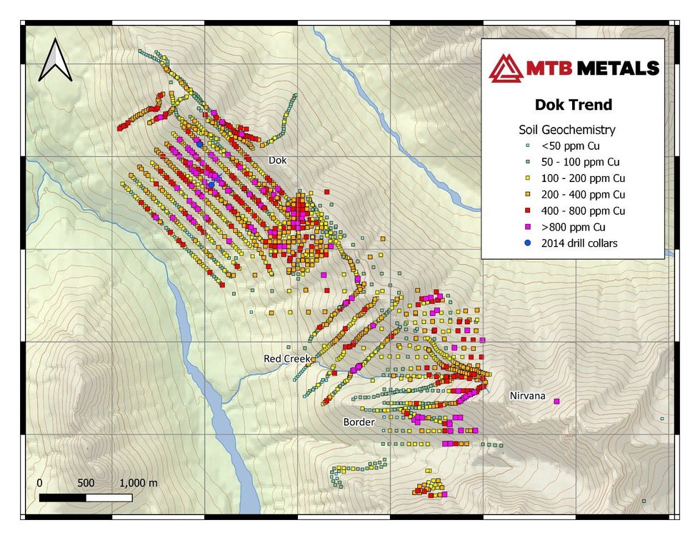
Figure 1- Current and Historic Soil Geochemistry for Copper on the Dok Trend
Currently, three styles of copper and gold mineralization have been identified. They include the following,
Targets along the Dok trend have been ranked based on their IP and 3DIP chargeability responses from the 2012 and 2022 ground surveys, the magnetic response from the 2012 airborne mag survey, soil geochemistry results, pXRF results, SWIR results and field observations from ground truthing of identified anomalies.
Lucia Theny, Vice President Exploration, stated: "The overlapping of multiple geological, geophysical and geochemical indicators is providing good confidence in our target selection and the team is excited to be able to test their hypothesis with the drill."
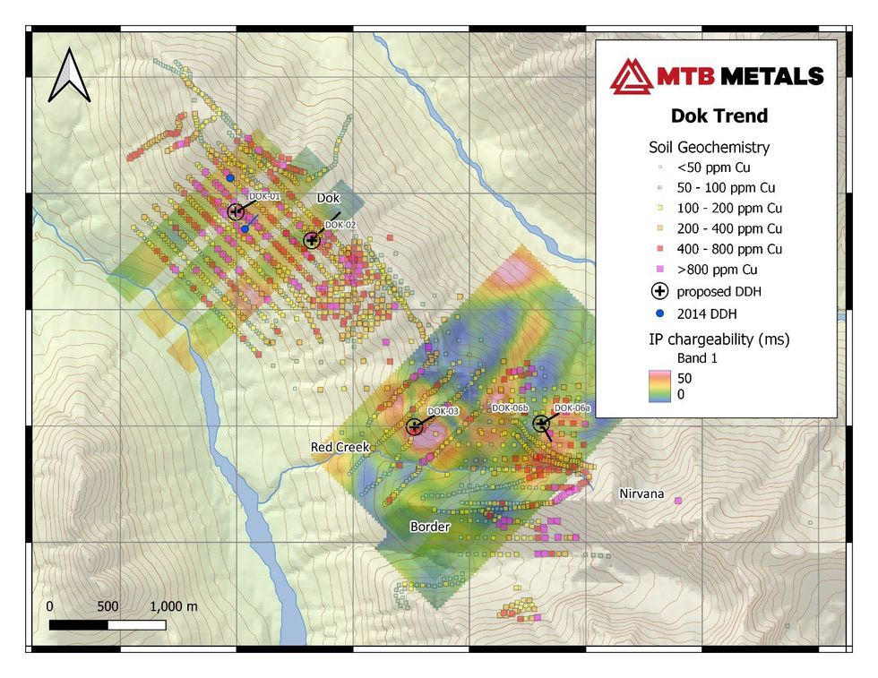
Figure 2 - Proposed Drill Holes for the Dok Trend on top of Copper Soil Geochemistry and Induced Polarization Chargeability
Lawrence Roulston, CEO, noted: "The geological team over the past two months carried out mapping, sampling and spectral analysis which confirmed the earlier information and filled in some gaps. These results provided a firm basis for selection of the initial drill targets. The team has worked methodically to advance the understanding of this huge geological system. This initial drill program will involve 2,000 to 3,000 meters of drilling from 3 drill pads, with the details of the program evolving based on observations as the drilling progresses. Use of the pXRF on the drill core will support the geological team's observations."
About MTB
MTB has six active projects spanning 670 square kilometres (67,587 hectares) in the prolific Golden Triangle of northern British Columbia. With the focus on the Telegraph project, discussions are now underway leading to joint ventures and/or spinouts of other projects.
On behalf of the Board of Directors:
Lawrence Roulston
President & CEO
For further information, contact:
Caroline Klukowski
info@mountainboyminerals.ca
NEITHER TSX VENTURE EXCHANGE NOR ITS REGULATION SERVICES PROVIDER (AS THAT TERM IS DEFINED IN THE POLICIES OF THE TSX VENTURE EXCHANGE) ACCEPTS RESPONSIBILITY FOR THE ADEQUACY OR ACCURACY OF THIS RELEASE.
This news release may contain certain "forward looking statements". Forward-looking statements involve known and unknown risks, uncertainties, assumptions and other factors that may cause the actual results, performance or achievements of the Company to be materially different from any future results, performance or achievements expressed or implied by the forward-looking statements. Any forward-looking statement speaks only as of the date of this news release and, except as may be required by applicable securities laws, the Company disclaims any intent or obligation to update any forward-looking statement, whether as a result of new information, future events or results or otherwise.