The Conversation (0)
Zeb Nickel Corp. (ZBNI:TSX-V) (OTC:ZBNIF) ("Zeb" or the "Company")
Zeb Nickel Corp ("ZEB" or the "Company") is pleased to report positive results from the independent interpretation of its high-power SpectremPlus™ airborne electromagnetic ("AEM") survey over the Zeb Nickel Project, Limpopo, South Africa. The AEM dataset has been integrated with the project's gravity and magnetic models to refine the geological framework and rank conductive anomalies along the ultramafic intrusive trend.
Highlights
- Coherent conductive responses identified: The interpretation delineates multiple discrete, laterally persistent conductors after screening for cultural and stratigraphic effects, with several features coincident with magnetic trends and intrusive margins which is consistent with the Company's chonolith/feeder-style nickel sulphide model.
- 3-D integration strengthens the geological case: Combining AEM, gravity and magnetics supports a focused corridor where sulphide accumulation is considered most plausible within or adjacent to the ultramafic package.
- De-risking pathway defined: The Company is advancing a follow-up programme that will include ground-based electromagnetic methods, downhole EM and complementary techniques to refine geometry, depth and conductance prior to selecting locations for initial drill-testing.
The interpretation of the recently completed Spectrem survey by Geofocus (Pty) Ltd outlines several clear, late-time conductive zones that cluster along the edges of the ultramafic body, interpreted to be a chonolith, and in close proximity to the magnetic and gravity shells. This spatial pattern is exactly what our chonolith/feeder model anticipates: nickel-copper-PGE sulphides commonly accumulate in ‘trap' sites along basal contacts and feeder embayments, often slightly offset from the densest and most magnetic core of the intrusion. By integrating the EM with magnetics and gravity in 3-D, we've narrowed targeting to a well-defined corridor where intrusion-related sulphide mineralisation is geologically plausible, while filtering out many responses more likely to reflect stratigraphy or surface effects. These results do not confirm mineralisation, but the alignment of independent datasets materially strengthens the technical case and provides a strong foundation for focused follow-up geophysics to refine geometry and prioritise drill-ready targets. The main conductor picks are presented in Figure 1 below.
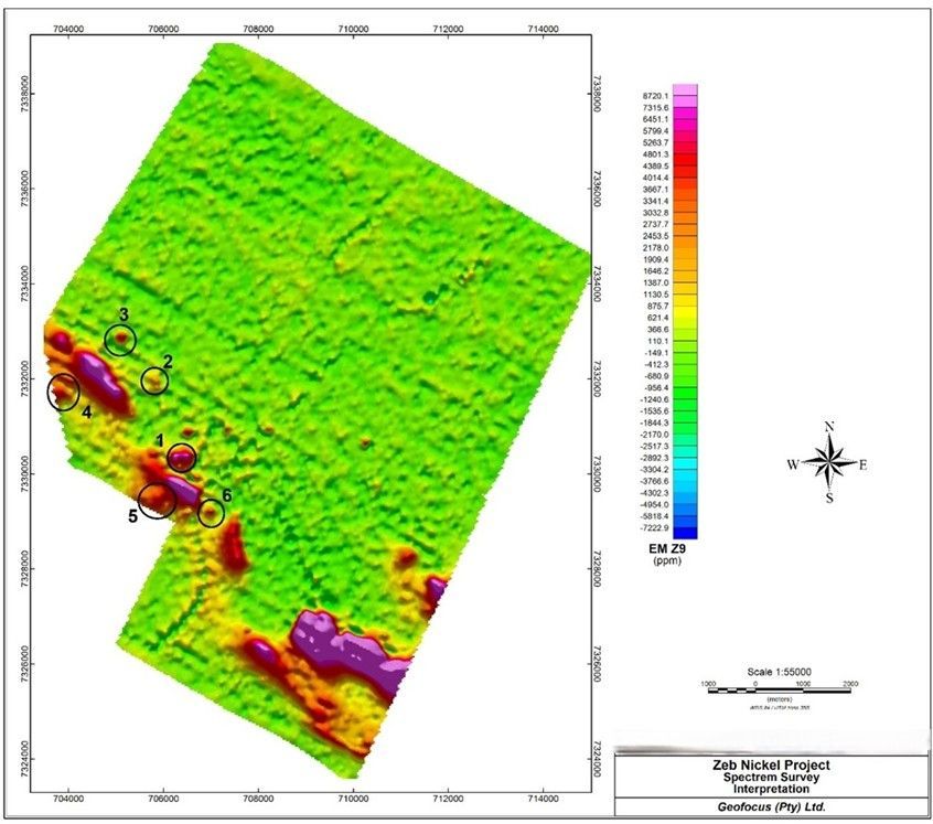
Figure 1: Late-time AEM response with conductor picks
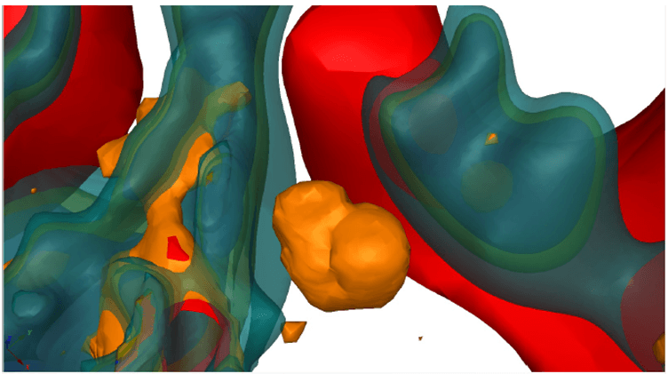
Figure 2: 3D view (looking north from above) The orange "cloud" shows a conductive zone detected by the EM survey. The red and blue outlines are earlier models of denser and more magnetic rock. The anomaly sits beside the Uitloop intrusion and close to those outlines, which fits how massive sulphides often occur: they tend to "pool" along the base or edges of an intrusion or in feeder embayments, slightly offset from the hardest, most magnetic core. This geometry is consistent with that setting, although it does not confirm mineralisation.
Next Steps
To increase precision ahead of any drill selection, the Company will conduct a ground-based geophysical survey over selected targets. The work may include a combination of moving-loop and/or fixed-loop EM and limited complementary methods where appropriate.
Ground-based surveys provide orientation-controlled, higher signal-to-noise measurements that enable constrained plate modelling of conductive bodies. This improves confidence in position, dip and strike, and helps discriminate compact, highly conducting sulphide targets from look-alikes such as banded iron formation, graphitic horizons, conductive weathering fronts or cultural coupling. In practical terms, follow-up geophysics reduces false positives, sharpens drill vectors and lowers the probability of unnecessary metres, thereby improving capital efficiency and technical outcomes.
The completion of the AEM survey combined with the ground based geophysical work is a key step for the Company in identifying the semi massive-massive sulphide discovery. The Company are working closely with the Mining department in country regarding the awarding of the Mining Rights and hope to be in a position to update shareholders soon. Upon successful awarding of the Mining Rights, the Company intends on embarking on an extensive drill programme to further prove up the deposit.
The Company is finalising the scope and sequencing of the follow-up programme and the Company will provide a further update once the programme selection, scheduling and access arrangements are complete.
Richard Montjoie, VP Exploration , commented:
" We're encouraged that the Spectrem results further support our intrusion-hosted chonolith/feeder model at Zeb. The conductive zones cluster along intrusive margins and align with magnetic and gravity shells, which is consistent with where our model anticipates potential sulphide traps. Our next step is to apply targeted ground geophysics to refine geometry and conductance, reduce false positives, and position any initial drill holes with greater confidence."
Highlights
- Survey completed safely and on budget.
- ~736 line‑kilometres flown at 150 m traverse spacing using Spectrem's converted DC‑3 turboprop platform equipped with the proprietary SpectremPlus™ system, capable of imaging conductive bodies to depths in excess of 700 m.
- Final, fully processed datasets, 3‑D inversion models and an integrated geophysical interpretation are expected in the near term.
- Deliverables will be integrated with existing gravity‑magnetic data to refine and prioritise drill targets focused on potential high‑grade nickel‑sulphide mineralisation.
Next Steps
The Spectrem Air team has begun final processing, following which the Company's geophysical consultant will complete a full interpretation and integration with the recently acquired gravity and magnetic datasets. Geofocus has been tasked with the integration of the geological, gravity, magnetic, and EM datasets into a unified 3D geophysical block model. Management anticipates releasing the results, together with an updated technical program and drill‑target inventory, shortly after receipt of the final deliverables, which are expected near the end of Q3 2025.
Richard Montjoie, VP of Exploration , commented:
" Completion of this state‑of‑the‑art AEM survey marks another key milestone for the Zeb Project. The high‑resolution data will underpin our next phase of exploration as we advance toward testing high‑grade nickel sulphide targets, which, if successful, will significantly move the needle on the Project."
Qualified Person Statement
All technical data, as disclosed in this press release, has been reviewed and approved by Richard Montjoie. Mr. Montjoie is the VP Exploration and director of the Company and is not, therefore, independent of the Company. Mr. Montjoie is a registered member of the South African Council for Natural Scientific Professions (SACNASP) membership number 400131/09. Mr. Montjoie holds a M.Sc. Honors in Economic Geology from the University of Witwatersrand, South Africa, and is fellow of the Geological Society of South Africa (GSSA). Mr. Montjoie Is a qualified person as defined under the terms of National Instrument 43-101.
About the Company and Project
Zeb Nickel Corp is focused on exploring for and developing world-class mineral deposits, with a focus on metals that are critical in the production of rechargeable batteries, such as nickel, graphite, lithium, cobalt, manganese, copper and aluminum. The Company is currently focused on developing its flagship Zeb Nickel Project, located in Limpopo, South Africa. The Zeb Nickel Project is a developing Class 1 nickel sulfide project strategically located in the Bushveld Complex in South Africa.
On behalf of the Board of Directors
James Nieuwenhuys
Chief Executive Officer and Director,
Zeb Nickel Corp.
Email: info@zebnickel.com
Tel: 1 416 628 3100
Company Website: www.zebnickel.com
Cautionary Note Regarding Forward-Looking Statements
This press release contains "forward-looking information" and "forward-looking statements" (collectively, "forward-looking statements") within the meaning of applicable Canadian securities legislation. All statements in this release, other than statements of historical fact, are forward-looking statements, including but not limited to: interpretations of geophysical data, the potential extension and connectivity of ultramafic bodies, the existence and extent of a feeder or plumbing system, the significance of magnetic and gravity anomalies, statements regarding the potential for massive Ni-Cu-PGE sulphide mineralisation, the planned re-processing and interpretation of geophysical data, the intention to delineate drill targets in Zone 2 and Zone 3, the objective of declaring a higher-grade maiden NI 43-101 compliant mineral resource, and the broader development strategy of the Zeb Project.
Forward-looking statements are based on a number of assumptions believed by management to be reasonable at the time such statements are made, including but not limited to: the accuracy of the Company's interpretation of geophysical and geological data, the availability of financing on reasonable terms, the ability to obtain necessary regulatory approvals in a timely manner, the results of planned exploration activities, and assumptions regarding market conditions and commodity prices.
Forward-looking statements are subject to known and unknown risks, uncertainties and other factors that may cause actual results, performance or achievements to differ materially from those expressed or implied by such statements. These risks and uncertainties include, but are not limited to: fluctuations in commodity prices, the outcome of current and future exploration and drilling programs, capital and operating costs varying significantly from estimates, the ability to secure financing and maintain access to capital markets, delays or inability to obtain necessary permits, approvals or licences, political and regulatory risks, environmental risks, and other risks related to mineral exploration and development.
There can be no assurance that such statements will prove to be accurate, and actual results and future events may differ materially from those anticipated. Readers are cautioned not to place undue reliance on forward-looking statements. All forward-looking statements contained in this press release are made as of the date hereof, and the Company undertakes no obligation to update publicly or revise any forward-looking statements, whether as a result of new information, future events or otherwise, except as required by applicable securities laws.
Photos accompanying this announcement are available at
https://www.globenewswire.com/NewsRoom/AttachmentNg/8bb3dc63-c66f-4ee5-ae00-778d191eff6a
https://www.globenewswire.com/NewsRoom/AttachmentNg/0762c9bf-4062-4644-9879-551d32305c68