The Conversation (0)

Saga Metals Corp. ("SAGA" or the "Company") (TSXV: SAGA,OTC:SAGMF) (OTCQB: SAGMF) (FSE: 20H), a North American exploration company focused on critical mineral discoveries, is pleased to announce the engagement of Dias Airborne Limited ("Dias") to conduct an airborne geophysical survey at the 100%-owned Radar Titanium-Vanadium-Iron Project near Cartwright, Labrador, Canada.
The state-of-the-art airborne geophysical survey will consist of 157 lines, averaging 7 km in length and spaced at 75m, covering the entire strike of the oxide layering connecting the Trapper and Hawkeye zones. Dias is expected to commence mobilization next week and execute the airborne survey towards the end of the month.
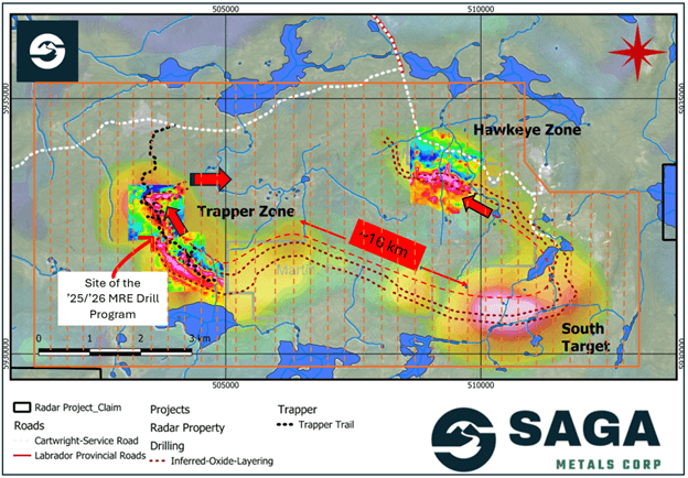
Figure 1: An approximate outline of the planned airborne geophysical coverage is highlighted in orange over Radar Project's prospective oxide layering zone. SAGA has demonstrated the reliability of the regional airborne magnetic surveys after validating with ground magnetic surveys and drilling in the 2024 -2026 field programs.
About Dias and the QMAGT Full Tensor Magnetic Gradiometry
Dias is a world leader in innovative geophysical technologies for mineral exploration, leading ground and airborne geophysical surveys.
The QMAGT system is a helicopter-borne magnetic survey system that measures the magnetic field in a robust and detailed manner. The SQUID (superconducting quantum interference device) sensor measures the complete gradient tensor (second-order) of the earth's magnetic field (otherwise known as full tensor magnetic gradiometry – FTMG). This FTMG measurement provides directional information about the magnetic field, which is not available from total field sensors, which have been the industry standard for many years.
The SQUID sensors are developed by Supracon AG of Jena, Germany. Operating within a liquid helium bath, the sensors measure the magnetic field with unrivaled sensitivity. The sensor system is the result of over 20 years of development and testing and has flown many successful exploration campaigns. The QMAGT system is the full commercialization of this established system.
The QMAGT system is deployed in a custom-built airfoil beneath a helicopter. This ‘bird' effectively reduces motion noise, allowing for the recovery of high-quality data. As a lightweight system, QMAGT can be deployed in most operating environments.
The benefits of the QMAGT system are enhanced resolution and detectability as well as improved geological modelling.
Michael Garagan, CGO & Director of Saga Metals, commented:
"Partnering with Dias Airborne to deploy their advanced QMAGT technology across the full strike of the oxide layering is a major milestone for the Radar Project. This survey will provide unprecedented resolution to verify the full extent of the magnetic anomalies across the entire system linking Hawkeye and Trapper. The resulting high-quality data will be critical for accurately modelling our geology and supporting the upcoming mineral resource estimate at Trapper while highlighting significant blue-sky potential well beyond the current drilling area."
2026 Trapper South Drilling Summary Reported to Date
| Drill Hole | Azimuth / Dip | Total Depth (m) | From (metres) | To (metres) | Semi-Massive Oxide (m) | Rhythmic Layering (m) | Total Downhole Oxide (m) | True Oxide Thickness (m) |
| R-0016 | 38° / -45° | 206 | 44 | 102 | 45.84 | 12.16 | 58 | 53.93 |
| R-0017 | 38° / -70° | 161 | 50.56 | 140.64 | 87.08 | 3 | 90.08 | 87.77 |
| R-0018 | 38° / -45° | 188 | 44.7 | 156.37 | 65.04 | 46.63 | 111.67 | 70.08 |
| R-0019 | 38° / -45° | 182 | 66.55 | 133 | 37.96 | 28.49 | 66.45 | 63.42 |
| R-0020 | 38° / -45° | 206 | 50.8 | 138 | 28.5 | 58.7 | 87.2 | 71.98 |
| R-0021 | 38° / -70° | 152 | 81.28 | 127.38 | 33.53 | 12.57 | 46.1 | 24.26 |
| R-0022 | 38° / -45° | 149 | 22.51 | 118.69 | 31.58 | 59.68 | 91.26 | 85.28 |
| R-0023 | 38° / -45° | 272 | 100.48 | 239.32 | 30.61 | 76.44 | 107.05 | 67.19 |
| R-0024 | 38° / -45° | 254 | 108.87 | 219.76 | 46.76 | 62.11 | 108.87 | 70.24 |
| R-0025 | 38° / -60° | 275 | 122.96 | 253.6 | 6.92 | 118.08 | 125 | 89.60 |
| R-0026 | 38° / -60° | 302 | 108.75 | 273.65 | 16.24 | 138.55 | 154.79 | 91.55 |
| R-0027 | 38° / -45° | 217 | 79.83 | 175.33 | 34.24 | 59.86 | 94.1 | |
| R-0028 | 38° / -60° | 227 | 105.07 | 215.93 | 22.46 | 87.1 | 109.56 | |
| R-0029 | 38° / -45° | 214 | 65.2 | 183.97 | 13.38 | 105.39 | 118.77 | |
| R-0030 | 38° / -60° | 211 | 83.05 | 189.18 | 25.41 | 79.55 | 104.96 | |
| R-0031 | 38° / -45° | 215 | 63.35 | 171.6 | 2.36 | 105.89 | 108.25 | |
| R-0032 | 38° / -60° | 263 | 53.82 | 214.74 | 18.49 | 135.95 | 154.44 | |
| R-0033 | 38° / -45° | 251 | 67.73 | 203.46 | 23.66 | 112.43 | 136.09 | |
| R-0034 | 38° / -60° | 233 | 48.68 | 214.14 | 66.11 | 93.54 | 159.65 | |
| R-0035 | 38° / -45° | 97 | 8.53 | 66.34 | 0 | 34.95 | 34.95 | |
| R-0036 | 38° / -70° | 212 | 47.41 | 128 | 68 | 8.57 | 76.57 | |
| R-0037 | 38° / -45° | 206 | 42.64 | 146 | 50.79 | 52.57 | 103.36 | |
| R-0038 | 38° / -70° | 182 | Logging in-progress | |||||
| R-0039 | 218° / -45° | 251 | Logging in-progress | |||||
| R-0040 | 38° / -70° | 170 | Logging in-progress | |||||
| R-0041 | 38° / -45° | 100 | Logging in-progress | |||||
| R-0042 | 38° / -70° | 161 | Logging in-progress | |||||
| R-0043 | 38° / -45° | 119 | Logging in-progress | |||||
| R-0044 | 218° / -45° | 176 | Logging in-progress | |||||
| R-0045 | 218° / -45° | 242 | Logging in-progress | |||||
| R-0046 | Drilling in-progress | |||||||
| Total (m) | 6,094 | |||||||
Table 1: Summary of drill holes R-0016 to R-0045, highlighting the oxide intercepts. Logging of R-0038 to R-0045 is in progress. See Figures 2-4 below, which depict the oxide mineralization in cross sections S5, S4 and S8. True thickness represents the perpendicular width of the mineralized zone, while the total downhole oxide represents the length of the mineralization intercepted downhole.
| Total Meters Drilled | Total Samples | |
| Trapper Zone 2025 | 2050 | 1313 |
| Trapper South 2026 | 6094 | 2823 |
| Trapper Total | 8144 | 4136 |
Table 2: Summary of total meters drilled in Q4 2025 and 2026 to date, including total core samples cut and prepared.
Key Project Highlights
| DDH | FROM | TO | Length | Fe2O3 | TiO2 | V205 |
| ID | m | m | m | % | % | % |
| R-0009 | 94 | 181.2 | 87.20 | 50.67 | 10.15 | 0.339 |
| R-0008 | 170 | 237.6 | 68.26 | 46.15 | 9.21 | 0.311 |
| R-0010 | 1.5 | 137 | 135.50 | 50.03 | 7.87 | 0.352 |
| R-0016 | 44 | 94.6 | 50.60 | 52.05 | 7.21 | 0.375 |
| R-0021 | 96 | 127.4 | 31.40 | 53.18 | 7.08 | 0.414 |
| R-0015 | 73.3 | 174 | 100.70 | 38.56 | 6.80 | 0.229 |
| R-0017 | 50.6 | 140.6 | 90.01 | 51.86 | 6.76 | 0.417 |
| R-0022 | 62 | 92.6 | 30.6 | 49.40 | 6.61 | 0.373 |
| R-0019 | 66.6 | 112.3 | 45.7 | 49.51 | 6.56 | 0.374 |
| R-0011 | 58.1 | 153.3 | 95.15 | 39.49 | 6.49 | 0.222 |
Table 3: Top 10 intercepts from the 2025 & 2026 drilling programs at the Trapper Zone
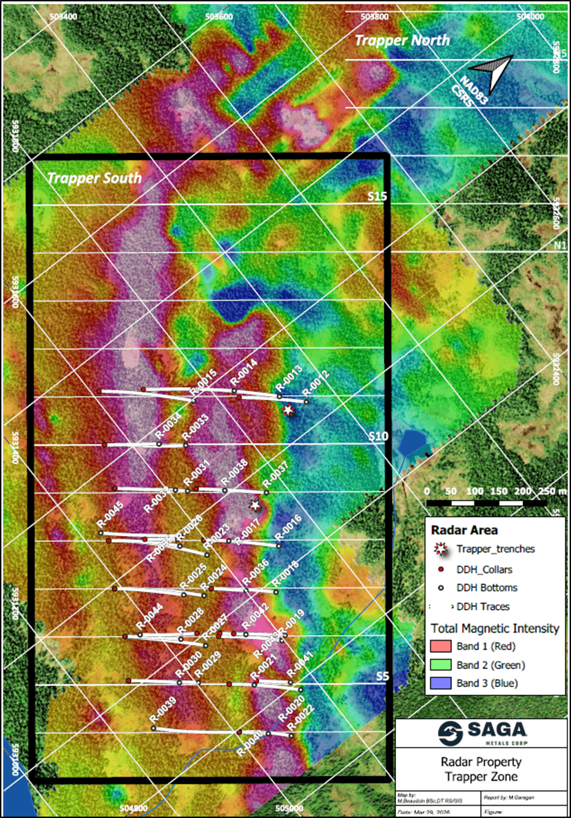
Figure 2: Trapper South map outlining location of the initial 2026 focus for the remainder of the MRE drill program to be completed in 2026, including cross-sections S11, S10, S9, S8, S7, S6, S5, and S4, showing the TMI of the 2025 Trapper Zone ground magnetic survey.
About the Radar Critical Mineral Property in Labrador
The Radar Property spans 24,175 hectares and hosts the entire Dykes River intrusive complex (about 160 km²), a unique position among Western explorers. Geological mapping, geophysics, and trenching have already confirmed oxide layering across more than 20 km of strike length, with mineralization open for expansion.
Vanadiferous titanomagnetite ("VTM") mineralization at Radar is comparable to global Fe–Ti–V systems such as Panzhihua (China), Bushveld (South Africa), and Tellnes (Norway), positioning the Project as a potential strategic future supplier of titanium, vanadium, and iron to North American markets.
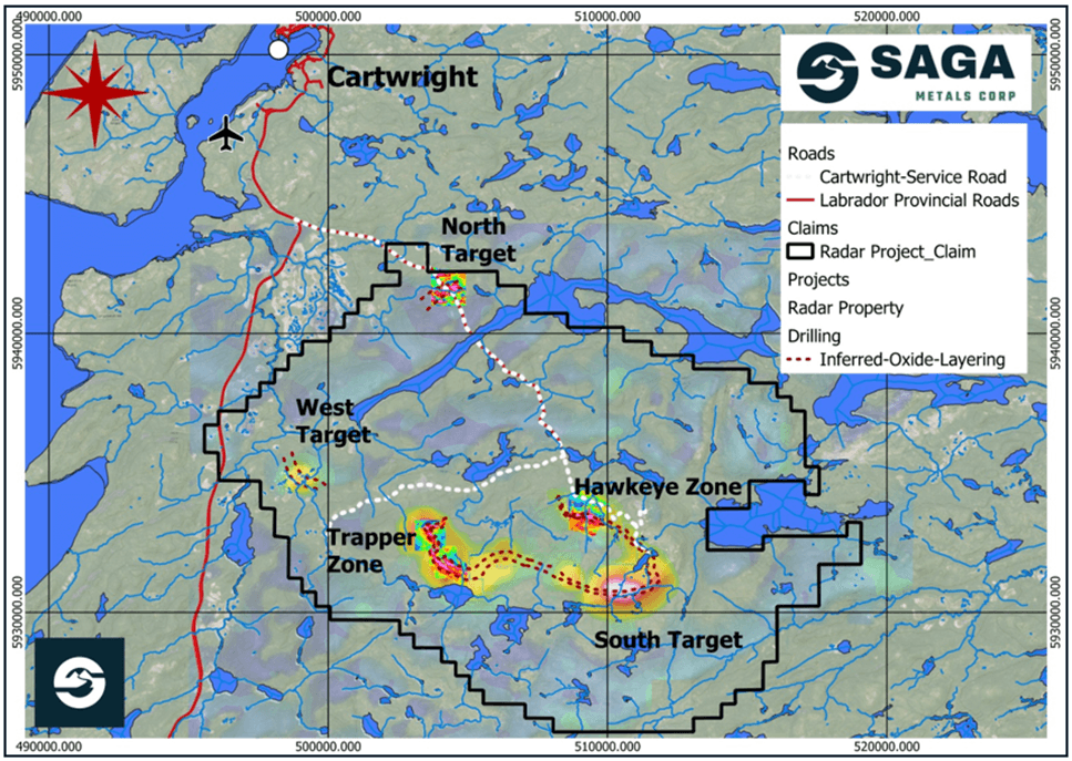
Figure 3: Radar Property map, depicting magnetic anomalies, oxide layering and the site of the 2025 drill programs. The Property is well serviced by road access and is conveniently located near the town of Cartwright, Labrador. A compilation of historical aeromagnetic anomalies is overlaid with ground-based geophysical data, as shown.
Qualified Person
Paul J. McGuigan, P. Geo., is an Independent Qualified Person as defined under National Instrument 43-101 and has reviewed and approved the technical information disclosed in this news release.
About Saga Metals Corp.
Saga Metals Corp. is a North American mining company focused on the exploration and discovery of a diversified suite of critical minerals that support the North American transition to supply security. The Radar Ti-V-Fe Project comprises 24,175 hectares and entirely encloses the Dykes River intrusive complex, mapped at 160 km² on the surface near Cartwright, Labrador. Exploration to date, including 10,353 m of drilling, has confirmed a large, mineralized layered mafic intrusion hosting vanadiferous titanomagnetite (VTM) and ilmenite mineralization with strong grades of titanium and vanadium.
The Double Mer Uranium Project, also in Labrador, covers 25,600 hectares and features uranium radiometrics that highlight an 18km east-west trend, with a confirmed 14km section producing samples as high as 0.428% U3O8. Uranium uranophane was identified in several areas of highest radiometric response (2024 Double Mer Technical Report).
Additionally, SAGA owns the Legacy Lithium Project in Quebec's Eeyou Istchee James Bay region. This project spans 65,849 hectares and shares significant geological continuity with other major players in the area, including Rio Tinto, Li-FT Power, SOQUEM, and Loyal Metals.
With a portfolio spanning key commodities critical to the clean energy future, SAGA is strategically positioned to play an essential role in securing critical minerals.
On Behalf of the Board of Directors
Mike Stier, Chief Executive Officer
For more information, contact:
Rob Guzman, Investor Relations
Saga Metals Corp.
Tel: +1 (844) 724-2638
Email: rob@sagametals.com
www.sagametals.com
Neither the TSX Venture Exchange nor its Regulation Service Provider (as that term is defined in the policies of the TSX Venture Exchange) accepts responsibility for the adequacy or accuracy of this release.
Cautionary Disclaimer
This news release contains forward-looking statements within the meaning of applicable securities laws that are not historical facts. Forward-looking statements are often identified by terms such as "will", "may", "should", "anticipates", "expects", "believes", and similar expressions or the negative of these words or other comparable terminology. All statements other than statements of historical fact, included in this release are forward-looking statements that involve risks and uncertainties. In particular, this news release contains forward-looking information pertaining to the Company's Radar Project. There can be no assurance that such statements will prove to be accurate, and actual results and future events could differ materially from those anticipated in such statements. Important factors that could cause actual results to differ materially from the Company's expectations include, but are not limited to, changes in the state of equity and debt markets, fluctuations in commodity prices, delays in obtaining required regulatory or governmental approvals, environmental risks, limitations on insurance coverage, inherent risks and uncertainties involved in the mineral exploration and development industry, particularly given the early-stage nature of the Company's assets, and the risks detailed in the Company's continuous disclosure filings with securities regulations from time to time, available under its SEDAR+ profile at www.sedarplus.ca. The reader is cautioned that assumptions used in the preparation of any forward-looking information may prove to be incorrect. Events or circumstances may cause actual results to differ materially from those predicted, as a result of numerous known and unknown risks, uncertainties, and other factors, many of which are beyond the control of the Company. The reader is cautioned not to place undue reliance on any forward-looking information. Such information, although considered reasonable by management at the time of preparation, may prove to be incorrect and actual results may differ materially from those anticipated. This cautionary statement expressly qualifies forward-looking statements contained in this news release. The forward-looking statements contained in this news release are made as of the date of this news release, and the Company will update or revise publicly any of the included forward-looking statements only as expressly required by applicable law.
Infographics accompanying this announcement are available at
https://www.globenewswire.com/NewsRoom/AttachmentNg/e6036dfe-40d1-450d-88ef-ca7eaeb6d506
https://www.globenewswire.com/NewsRoom/AttachmentNg/2ba4c238-b2cc-4a13-ac18-639bbc6974a0
https://www.globenewswire.com/NewsRoom/AttachmentNg/a82b3918-21a7-4642-a6e2-0a78d445a77a
![]()
News Provided by GlobeNewswire via QuoteMedia