The Conversation (0)

(TheNewswire)
 | |||||||||
Vancouver, British Columbia TheNewswire - December 7, 2022 - Leocor Gold Inc. (the " Company " or " Leocor ") (CSE: LECR, OTCQB: LECRF; Frankfurt: LGO) is pleased to announce it has received Rotary Air Blast ("RAB") drill results on the Company's Baie Verte project located near Anaconda Mining's Pine Cove Mine and Rambler Metal's Ming Mine in northwestern Newfoundland.
The Phase 1 program tested at least six different target areas for gold and/or copper mineralization with 18 RAB drill holes and was designed to follow up on previously announced soil and GT Probe results (1) ; evaluating the targets for potential follow up diamond drilling as warranted. Results from 12 of the holes on the gold targets are discussed in this news release, and the results from the additional six holes on the Copper Creek Trend will released in due course.
Highlights from the gold targets include:
Sharpie Ridge Target: 2.32 grams-per-tonne ("g/t") gold ("Au") over 10.67m; including 10.2 g/t Au over 1.52m. New target that is open along strike and at depth.
Braz NE Target: 3.18 g/t Au over 4.57m from surface. New target that is open along strike and at depth.
Dorset Main Target: 1.41 g/t over 7.62m. Confirming geometry of the mineralized zone.
"We're very pleased with the new discoveries on the consolidated Baie Verte package," said CEO, Alex Klenman. "The technical team has done great work to advance the project and our understanding of the mineralized zones. These new targets represent even more upside, and it appears the ground has more to give. We're anxious to see the upcoming Copper Creek results, then we'll move towards diamond drilling," continued Mr. Klenman.
2022 RAB Drill Program
The 2022 RAB Drilling program consisted of 1023m of drilling over 18 holes and tested 6 target areas across the Baie Verte property including the Dorset, Gunshot, Gunshot Extension, Sharpie Ridge, Braz NE, and Copper Creek target areas. The program followed up on previously announced gold and copper soil and GT Probe results over a 7km trend across the property (1) and is designed to evaluate the targets for potential diamond drilling. Results for 12 of the 18 holes, focused on the gold target areas, are included in this release. Additional result from the Copper Creek Trend will be released in due course.
The RAB drilling was be completed by GroundTruth Exploration Inc. using their "GT RAB Drill," a Heli-Portable, wireless remote-controlled, rubber tracked platform with a hydraulic tilting mast assembly and rotary drill head. The GT RAB Drill is environmentally friendly with low-ground pressure and minimal surface disturbance. Individual drill holes can be up to 100m in depth and are paired with onsite XRF analysis and optical televiewer surveys, allowing rapid evaluation of the target areas.
Individual results for the drilling ranged from below detection to 10.2g/t Au and are summarized in Table 1 below. A drill collar table and associated map for the results included in this release are included in Table 2 and Figure 1 below. All intervals are reported as drilled and there is not currently enough information to determine true thickness at this time. It should also be noted that none of the holes reached the originally planned 100m target depth do to challenging ground conditions.
(1) See the Companies new release dated May 19, 2022. Available at leocorgold.com and SEDAR.
Table 1: RAB Drill Results from gold targets on the Baie Verte Project
| Hole ID | Target | From (m) | To (m) | Interval (m) | Au g/t) |
| DORRAB22-001 | DOR Main | 28.96 | 36.58 | 7.62 | 1.41 |
| DORRAB22-002 | DOR Main | 28.96 | 35.05 | 6.10 | 1.14 |
| DORRAB22-003 | DOR/Gunshot Extension | 27.43 | 30.48 | 3.05 | 0.57 |
| DORRAB22-004 | DOR/Gunshot Extension | No Significant Results | |||
| DORRAB22-005 | DOR/Gunshot Extension | 1.52 | 19.81 | 18.29 | 0.21 |
| DORRAB22-006 | Sharpie Ridge | No Significant Results | |||
| DORRAB22-007 | Sharpie Ridge | 15.24 | 25.91 | 10.67 | 2.32 |
| Incl. | 15.24 | 16.76 | 1.52 | 10.2 | |
| DORRAB22-008 | Sharpie Ridge | No Significant Results | |||
| DORRAB22-009 | Sharpie Ridge | No Significant Results | |||
| DORRAB22-010 | BRAZ NE | 0.00 | 4.57 | 4.57 | 3.18 |
| DORRAB22-011 | Gunshot | 18.29 | 19.81 | 1.52 | 0.64 |
| DORRAB22-012 | Gunshot | No Significant Results | |||
Table 2: RAB Drill Collars from gold targets on the Baie Verte Project
| Hole ID | Target Area | Easting | Northing | Elevation (m) | Azimuth | Dip | Depth (m) |
| DORRAB22-001 | DOR Main | 555375.1 | 5527046 | 103 | 135 | 55 | 42.67 |
| DORRAB22-002 | DOR Main | 555383.5 | 5527058 | 101 | 135 | 55 | 39.62 |
| DORRAB22-003 | Gunshot Extension | 554554.6 | 5526404 | 176 | 135 | 60 | 56.39 |
| DORRAB22-004 | Gunshot Extension | 554641.2 | 5526466 | 159 | 135 | 60 | 71.63 |
| DORRAB22-005 | Gunshot Extension | 554648.6 | 5526588 | 158 | 135 | 60 | 53.34 |
| DORRAB22-006 | Sharpie Ridge | 553510.7 | 5526370 | 206 | 295 | 60 | 79.25 |
| DORRAB22-007 | Sharpie Ridge | 553491.8 | 5526318 | 204 | 295 | 60 | 53.34 |
| DORRAB22-008 | Sharpie Ridge | 553508.4 | 5526240 | 197 | 295 | 60 | 70.1 |
| DORRAB22-009 | Sharpie Ridge | 553513.2 | 5526237 | 197 | 115 | 60 | 44.2 |
| DORRAB22-010 | BRAZ NE | 555081.6 | 5527013 | 134 | 135 | 60 | 48.77 |
| DORRAB22-011 | Gunshot | 555063.7 | 5527091 | 135 | 135 | 60 | 51.82 |
| DORRAB22-012 | Gunshot | 555058 | 5527093 | 140 | 315 | 60 | 48.77 |
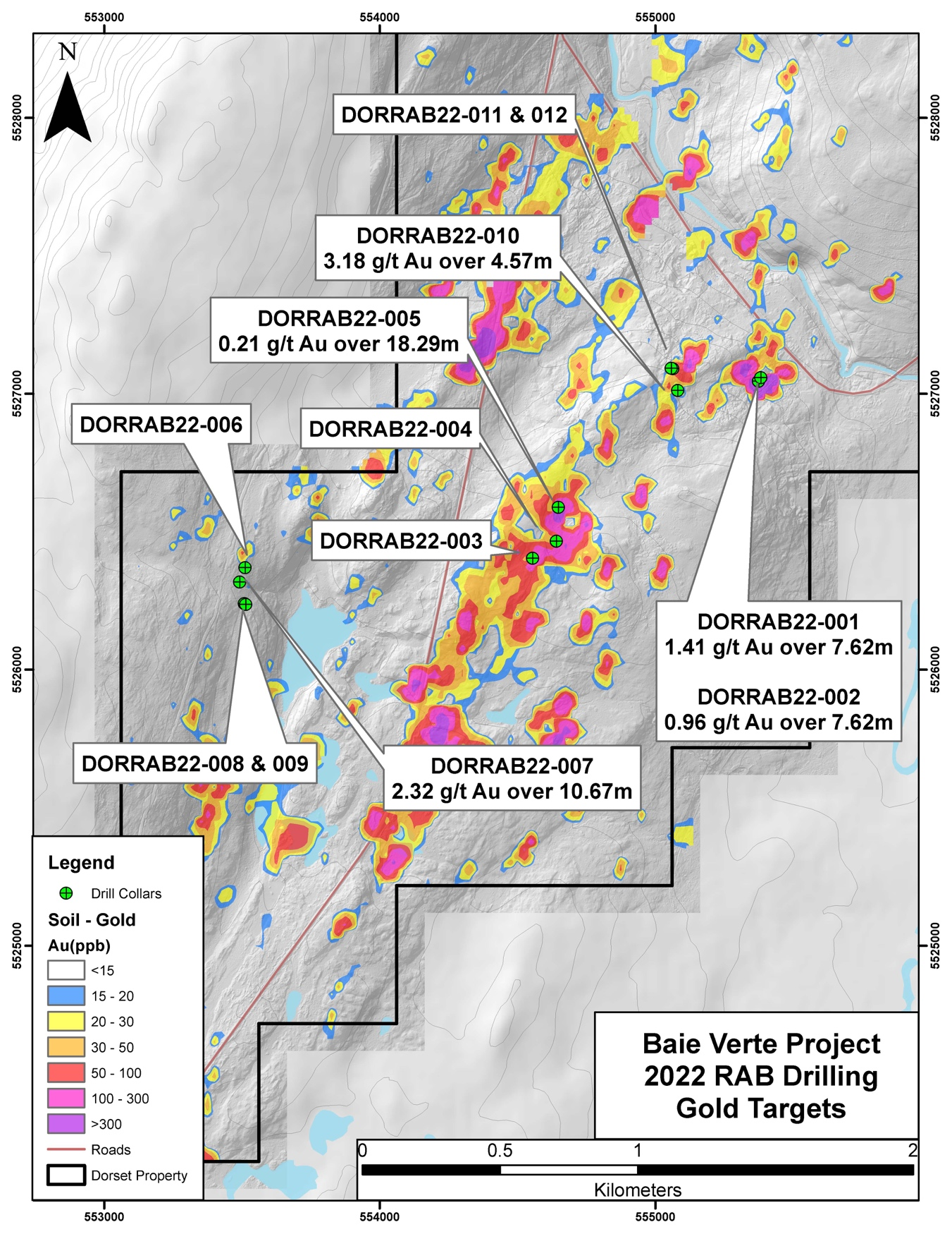
Click Image To View Full Size
Figure 1: Fall 2022 drill locations, Dorset claims, Baie Verte Project, NW Newfoundland
Sharpie Ridge
Four holes (006 – 009) were drilled on the Sharpie Ridge target. The drilling was assessing alteration and mineralization along a NE trending fault-controlled contact of fuchsite altered ultramafic and metavolcanic rocks. The holes were drilled over a 130m strike length and were centered on an outcrop of strongly silicified outcrop with assays up to 1.31 g/t Au. Hole -007 was drilled adjacent to the mineralized outcrop and intersected strongly silicified and quartz veined metavolcanic and ultramafic returning 2.32 g/t Au over 10.32m from 15.24m depth; including 10.2 g/t Au over 1.52m. Holes (006 & 008/009) were collared 55 and 80m north and south of -007; respectively. These holes failed to interest the mineralized structure due to hole placement/dip, and only returned anomalous results. The drill results on Sharpie Ridge are significant because it is a new discovery and is at the NE end of a 1.8km gold in soil anomaly associated with the same faulted contact. Follow up drilling will continue to assess the strike and dip extent of mineralization on the target.
Dorset
Two holes (-002 & -002) were drilled on the Dorset target evaluating the historic Dorset prospect which hosts rock samples up to 57.2 g/t Au from NE striking, steeply west dipping quartz veins and breccia zones sericite-ankerite alteration and pyrite, arsenopyrite, and, locally, visible gold mineralization. The holes were drilled approximately 15m apart and were designed to evaluate the geometry and dip of the mineralization. Both holes interested intersected mineralization at 28.96m depth and returned 1.41 g/t over 7.62m (-001) and 1.14 g/t Au over 6.10m (-002); respectively. The holes confirmed the geometry of the mineralized zone and will guide follow up drilling efforts to assess the strike and dip extent of the zone and evaluate it for higher grade, plunging shoots, of gold mineralization.
DOR/Gunshot Extension
Three holes (-003 to -005) were drilled on the DOR/Gunshot Extension target, located approximately 950m SW of Dorset. The target consists of 1.6km, NE trending, gold in south anomaly with anomalous GT Probe results (up to 1.19 g/t Au). RAB drilling was conducted on the NE end of the trend with the three holes placed approximately 100m apart. Holes -003 and -005 returned zones of anomalous Au mineralization (>0.1 g/t Au) with highlights of 0.57 g/t Au over 3.05m from 27.43m depth from hole -003 and 0.21 g/t Au over 18.29m from 1.52m depth in hole -005.
Gunshot
Two holes (-011 & -012) were drilled on the Gunshot target located approximately 345m west of the Dorset target. The drilling was targeting NE striking gold in soil and GT Probe anomalies (up to 1.97 g/t Au). The holes were, effectively, drilled from the same location (with 5m) at azimuths of 135 and 315; respectively. Only hole -011 encountered anomalous mineralization with the best intercept returning 0.64 g/t Au over 1.52m from 18.29m depth.
Braz NE
One hole was drilled on the Braz NE target, located 80m south of Gunshot. The drilling was targeting a 5m wide outcrop of sheared metavolcanic rocks with sheeted quartz veins and sericite alteration. The hole returned 3.18 g/t Au over 4.57m from surface and will be a target for follow up drilling on the property.
Assay Methodology and QA/QC
All RAB samples were prepared and analyzed by Bureau Veritas Laboratories. Samples were submitted to their Timmins, ON laboratory for preparation with pulps sent to their Vancouver, BC laboratory for assay. The samples were were crushed to 70% passing -2 mm and then splitting off and pulverizing a 250-gram split to 85% passing -75 microns (PRP70-250). A 0.5 gram cut of the pulp was analyzed by AQ201, an aqua regia digestion followed by ICP-MS analysis for 36 elements. Gold was analyzed for by FA430 using a 30-gram charge for a standard fire assay with an AA finish. If Au results were >10 g/t a second 30-gram charge was used for a standard fire assay with a gravimetric finish.
The reported work will be completed using industry standard procedures, including a quality assurance/quality control ("QA/QC") program consisting of the insertion of certified standard, blanks, and duplicates into the sample stream.
Click Image To View Full Size
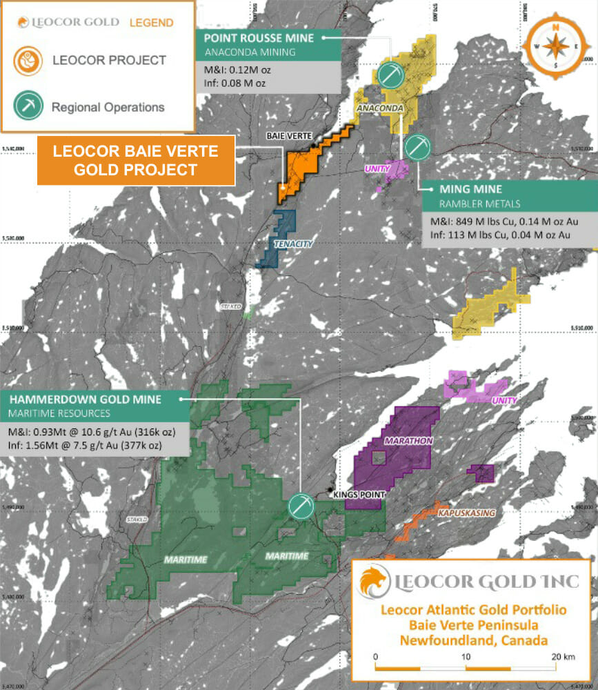
Figure 3 – Regional Setting of the Baie Verte Project
About Leocor's Baie Verte Project
The Baie Verte Peninsula represents one of the more productive and historical gold and base metal mining districts in Canada. The former Terra Nova base metal mine – one of several copper mines of the region, which operated during the late 1880's to early 1900's – lies 200 meters west of Leocor's Copper Creek claims. Former gold mining operations in the area include the Goldenville mine (of 1903-1906), located 8 km NE of the property, and the more recent Nugget Pond mine (1997-2000) of the eastern Baie Verte Peninsula area. Currently producing mines in the area include the Rambler base metal-gold mine (1961-present), located 14 km ESE of Baie Verte, and the Pine Cove and Stogertite mines (collectively, 2011-present) located 1.6 km and 5.4 km NE of the current property.
The Baie Verte project combines the Dorset, Dorset Extension, Five Mile Brook and Copper Creek projects consisting of fourteen mineral licenses, totalling 80 claims, and covering 1995 hectares (19.95 square km).
The Dorset Gold Project is a 275-ha gold exploration project, located south of the Pine Cove Gold Mine, and features multiple zones of high-grade gold mineralization. The Main Dorset Zone includes three historic showings, referred to as Dorset 1, 2 and 3 Showings. Grab samples from Dorset 1 returned 407.9, 349.2, 147.1, 143.9, 138.2, 108.0, 106.7, 72.4 and 30.0 g/t Au. Grab samples from Dorset 2 returned 167.0, 96.12, 84.3, 49.7, 23.8,4.33 and 1.33 g/t Au (MacDougall and Walker, 1988) and a "combined assay of 56.0 g/t Au over 2.5m" (MacDougall 1989) . Historic drilling includes DDH 87-1, which intersected 9.5 g/t Au over 1.3m (MacDougall and Walker, 1988).
Historic select sampling at the Braz Zone returned values of 314 g/t Au, 40 g/t Au, 31.4 g/t Au, 21.2 g/t Au, 19.2 g/t Au and 14.8 g/t Au. Historic channel sampling across the vein returned 9.5 g/t Au over 0.4m, 5.7 g/t Au over 0.5m and 1.2 g/t Au over 0.65m. Weighted averages of historic rock sampling encompassing vein and mineralized wall rock returned values of 5.8 g/t Au over 1.9m, 3.1 g/t Au over 2m and 2.5 g/t Au over 1.5m (MacDougall, 1990).
Other zones include The Albatross, where historic rock sampling of mineralized zones returned values up to 30.3 g/t Au. Assay results from three 1987 diamond drill holes include 1.0 g/t Au over 7.3m, 1.81 g/t over 4.3m and 1.02 g/t over 2.2m and the Gunshot Zone, where veins containing visible gold and pyrite returned grab samples that assayed up to 162 g/t Au and channel samples that assayed up to 18 g/t Au over 0.4m (MacDougall, 1989)
In the Phoenix Zone, "assays from initial grab samples returned 5.8 and 5.5 g/t within the gabbro. Quartz veins have returned 1.4, 0.6 and 0.5 g/t Au. Similar mineralization located 500m north east returned 3.3 g/t." (MacDougall, 1987). Diamond drilling hole intersected of 1.07 g/t Au over 5.45m (MacDougall, 1989).
Copper Creek (1,025-ha) hosts a number of gold prospects and copper occurrences associated with extensive alteration/shear zones developed within a thrust-faulted sequence of quartz-Fe-carbonate-fuchsite-altered gabbros, ultramafics and mafic volcanics, of the Advocate (ophiolite) Complex, and intermediate to silicic volcaniclastics & tuffs and microgabbroic dykes/sills, of the Flatwater Pond (cover sequence) Group. Historical results at Copper Creek – Biarritz zone include "values ranging from 1.3 to 16 g/t Au from grab samples and a combined assay of 3.9 g/t Au over 4.0m from detailed chip sampling." Additionally, "300m SW along strike exposed a 5-10m shear zone with similar alteration returned which returned sporadic values up to 9,2 g/t Au from grab samples" Noranda drilled several diamond holes in the area including A-88-7 which returned 0.66 g/t Au over 1.5 m and A-88-9 which returned 3.11 g/t Au over 0.5 m. (MacDougall, 1989).
Five Mile Brook (350-ha) has been subject to minimal exploration in the past but shows potentially important geological continuity to the Company's Dorset Gold Project, which lies directly contiguous to the northern boundary.
* Historic rock samples and grab samples mentioned in this release are selective by nature and are unlikely to represent average grades of the property
* The reported drill intercept is an intersected length and is not a true width
The data reported here is historic in nature and has not yet been verified by a Qualified Person. Leocor has relied on the information supplied in the Noranda assessment reports (quoted above) and from information found in MODS (Mineral Occurrence Data System) published by the Newfoundland Department of Natural Resources.
National Instrument 43-101 Disclosure
Jodie Gibson, P.Geo., consultant, and a Qualified Person as defined by National Instrument 43-101, has reviewed, and approved the scientific technical content of this release.
About Leocor Gold Inc.
Leocor Gold Inc. is a British Columbia-based resource company involved in the acquisition and exploration of precious metal projects, with a current focus in Atlantic Canada. Leocor, through outright ownership and earn-in agreements, currently controls several gold-copper projects in prime exploration ground located within the prolific Baie Verte Mining District. Leocor's Bae Verte portfolio includes the Dorset, Dorset Extension, Copper Creek and Five Mile Brook projects, creating a contiguous nearly 2,000 hectare exploration corridor. The Company also controls the 6,847-ha grassroots Startrek project near Gander, as well as three district scale land packages in North Central Newfoundland, known as Robert's Arm, Hodge's Hill, and Leamington, (collectively "Western Exploits") representing over 144,000 hectares (1,440 square kilometers) of prospective exploration
Contact Information
Leocor Gold Inc.
Alex Klenman, Chief Executive Officer
Email : aklenman@leocorgold.com
Telephone : (604) 970-4330
Neither the Canadian Securities Exchange nor its Regulation Services Provider (as that term is defined in the policies of the Canadian Securities Exchange) accepts responsibility for the adequacy or accuracy of this release .
Cautionary Statements Regarding Forward-Looking Information
This press release contains forward-looking information within the meaning of Canadian securities laws. Such information includes, without limitation, information regarding the terms and conditions of the Option. Although Leocor believes that such information is reasonable, it can give no assurance that such expectations will prove to be correct.
Forward looking information is typically identified by words such as: "believe", "expect", "anticipate", "intend", "estimate", "postulate" and similar expressions, or are those, which, by their nature, refer to future events. Leocor cautions investors that any forward-looking information provided by Leocor is not a guarantee of future results or performance, and that actual results may differ materially from those in forward looking information as a result of various factors, including, but not limited to: the agreement of the parties to proceed with the proposed transaction on the terms set out in the Option Agreements or at all; Leocor's ability to exercise the Options; the state of the financial markets for Leocor's securities; the state of the natural resources sector in the event the Option, or any of them, are completed; recent market volatility; circumstances related to COVID-19; Leocor's ability to raise the necessary capital or to be fully able to implement its business strategies; and other risks and factors that Leocor is unaware of at this time. The reader is referred to Leocor's initial public offering prospectus for a more complete discussion of applicable risk factors and their potential effects, copies of which may be accessed through Leocor's issuer page on SEDAR at www.sedar.com.
The forward-looking statements contained in this press release are made as of the date of this press release. Leocor disclaims any intention or obligation to update or revise any forward-looking statements, whether as a result of new information, future events or otherwise, except as required by law.
Copyright (c) 2022 TheNewswire - All rights reserved.
News Provided by TheNewsWire via QuoteMedia